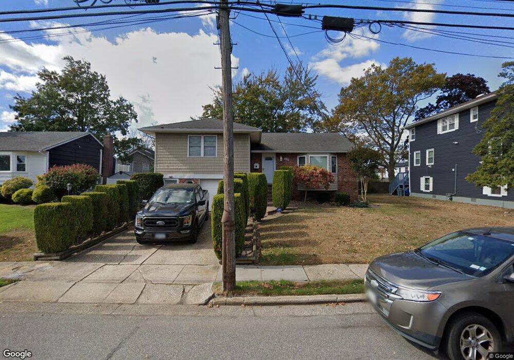
156 Nassau Ave Freeport, NY 11520
Estimated Value: $687,000 - $735,292
4
Beds
3
Baths
1,578
Sq Ft
$451/Sq Ft
Est. Value
About This Home
This home is located at 156 Nassau Ave, Freeport, NY 11520 and is currently estimated at $711,146, approximately $450 per square foot. 156 Nassau Ave is a home located in Nassau County with nearby schools including Columbus Avenue School, Caroline G. Atkinson Intermediate School, and John W Dodd Middle School.
Ownership History
Date
Name
Owned For
Owner Type
Purchase Details
Closed on
Sep 29, 1999
Sold by
Strickland Cyrus R and Strickland Barbara F
Bought by
Strickland Barbara Cannetti
Current Estimated Value
Home Financials for this Owner
Home Financials are based on the most recent Mortgage that was taken out on this home.
Original Mortgage
$3,144
Outstanding Balance
$914
Interest Rate
7.8%
Mortgage Type
Purchase Money Mortgage
Estimated Equity
$710,232
Create a Home Valuation Report for This Property
The Home Valuation Report is an in-depth analysis detailing your home's value as well as a comparison with similar homes in the area
Home Values in the Area
Average Home Value in this Area
Purchase History
| Date | Buyer | Sale Price | Title Company |
|---|---|---|---|
| Strickland Barbara Cannetti | $35,000 | Fidelity National Title Ins |
Source: Public Records
Mortgage History
| Date | Status | Borrower | Loan Amount |
|---|---|---|---|
| Open | Strickland Barbara Cannetti | $3,144 |
Source: Public Records
Tax History
| Year | Tax Paid | Tax Assessment Tax Assessment Total Assessment is a certain percentage of the fair market value that is determined by local assessors to be the total taxable value of land and additions on the property. | Land | Improvement |
|---|---|---|---|---|
| 2025 | $6,564 | $434 | $172 | $262 |
| 2024 | $820 | $428 | $169 | $259 |
Source: Public Records
Map
Nearby Homes
- 310 Miller Ave
- 322 Miller Ave
- 494 S Ocean Ave Unit 1M
- 494 S Ocean Ave Unit 1H
- 494 S Ocean Ave Unit 3A
- 267 Roosevelt Ave
- 265 Roosevelt Ave
- 119 S Bay Ave
- 208 Sportsmans Ave
- 173 Cedar St
- 177 Sportsmans Ave
- 160 Saint Marks Ave
- 470 Miller Ave
- 335 Arthur St
- 254 Arthur St
- 226 Westside Ave Unit B
- 16 Layton St
- 22 Wilshire Ct
- 120 Sportsmans Ave
- 39 Layton St
- 162 Nassau Ave
- 150 Nassau Ave
- 501 S Long Beach Ave
- 499 S Long Beach Ave
- 507 S Long Beach Ave
- 155 Nassau Ave
- 159 Nassau Ave
- 136 Nassau Ave
- 168 Nassau Ave
- 493 S Long Beach Ave
- 137 Nassau Ave
- 137 Nassau Ave
- 511 S Long Beach Ave
- 165 Nassau Ave
- 132 Nassau Ave
- 143 Nassau Ave
- 477 S Long Beach Ave
- 174 Nassau Ave
- 112 Front St
Your Personal Tour Guide
Ask me questions while you tour the home.