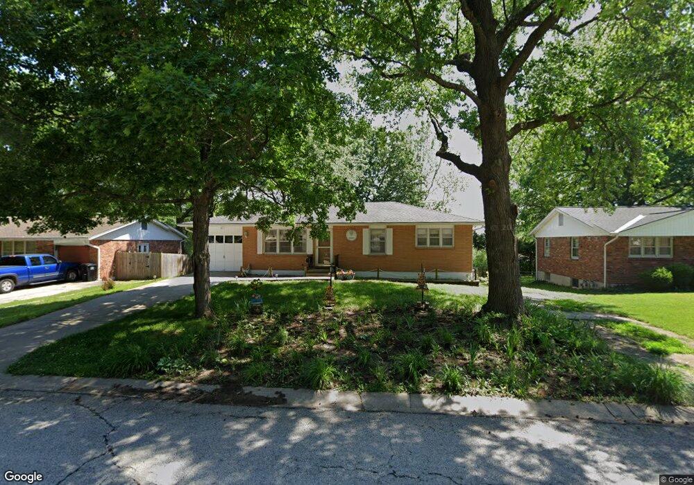
15601 E 43rd St S Independence, MO 64055
Southern NeighborhoodEstimated Value: $196,920 - $214,000
3
Beds
1
Bath
1,040
Sq Ft
$198/Sq Ft
Est. Value
About This Home
This home is located at 15601 E 43rd St S, Independence, MO 64055 and is currently estimated at $206,230, approximately $198 per square foot. 15601 E 43rd St S is a home located in Jackson County with nearby schools including William Southern Elementary School, Bridger Middle School, and Pioneer Ridge Middle School.
Ownership History
Date
Name
Owned For
Owner Type
Purchase Details
Closed on
Jul 31, 2017
Sold by
Batschelet Gloria J
Bought by
Batcshelet Gloria J and Gloria J Batschelet Trust
Current Estimated Value
Purchase Details
Closed on
Sep 13, 2005
Sold by
Pozek Lou
Bought by
Batschelet Gloria J
Home Financials for this Owner
Home Financials are based on the most recent Mortgage that was taken out on this home.
Original Mortgage
$105,169
Interest Rate
5.8%
Mortgage Type
FHA
Create a Home Valuation Report for This Property
The Home Valuation Report is an in-depth analysis detailing your home's value as well as a comparison with similar homes in the area
Home Values in the Area
Average Home Value in this Area
Purchase History
| Date | Buyer | Sale Price | Title Company |
|---|---|---|---|
| Batcshelet Gloria J | -- | None Available | |
| Batschelet Gloria J | -- | -- |
Source: Public Records
Mortgage History
| Date | Status | Borrower | Loan Amount |
|---|---|---|---|
| Previous Owner | Batschelet Gloria J | $105,169 |
Source: Public Records
Tax History
| Year | Tax Paid | Tax Assessment Tax Assessment Total Assessment is a certain percentage of the fair market value that is determined by local assessors to be the total taxable value of land and additions on the property. | Land | Improvement |
|---|---|---|---|---|
| 2025 | $1,507 | $22,117 | $4,760 | $17,357 |
| 2024 | $1,473 | $21,753 | $4,718 | $17,035 |
| 2023 | $1,473 | $21,753 | $4,718 | $17,035 |
| 2022 | $1,628 | $22,040 | $4,817 | $17,223 |
| 2021 | $1,627 | $22,040 | $4,817 | $17,223 |
| 2020 | $1,564 | $20,576 | $4,817 | $15,759 |
| 2019 | $1,539 | $20,576 | $4,817 | $15,759 |
| 2018 | $1,513 | $19,315 | $3,201 | $16,114 |
| 2017 | $1,513 | $19,315 | $3,201 | $16,114 |
| 2016 | $1,490 | $18,831 | $3,718 | $15,113 |
| 2014 | $1,415 | $18,283 | $3,610 | $14,673 |
Source: Public Records
Map
Nearby Homes
- 15501 E 43rd Terrace S
- 15504 E 44th Terrace S
- 15412 E 42nd Place
- 4543 S Saville Ct
- 4223 E 42nd Street Ct
- 4705 S Brentwood Ave
- 4707 S Brentwood Ave
- 14722 E 43rd St S
- 4709 S Brentwood Ave
- 4711 S Brentwood Ave
- 4712 S Brentwood Ave
- 4714 S Brentwood Ave
- 15010 Highway 40 W
- 4515 S Phelps Rd
- 4317 S Megan Ct Unit 19
- 4731 Haden Ct
- 14700 U S 40
- 4517 S Fremont Rd
- 15531 E 48th St
- 15521 E 48th St
- 15513 E 43rd St S
- 15605 E 43rd St S
- 15600 E 43rd St S
- 15509 E 43rd St S
- 15604 E 43rd St S
- 15512 E 43rd St S
- 15600 E 43rd Terrace S
- 15608 E 43rd St S
- 15508 E 43rd St S
- 15505 E 43rd St S
- 15613 E 43rd St S
- 15602 E 43rd Terrace S
- 15615 E 43rd St S
- 15604 E 43rd Terrace S
- 15612 E 43rd St S
- 15504 E 43rd St S
- 15504 E 43rd Terrace S
- 15608 E 43rd Terrace S
- 15501 E 43rd St S
- 15502 E 43rd Terrace S
Your Personal Tour Guide
Ask me questions while you tour the home.