Estimated payment $1,490/month
Highlights
- Popular Property
- Wood Flooring
- 1 Car Detached Garage
- Colonial Architecture
- No HOA
- 3-minute walk to Shelly Park
About This Home
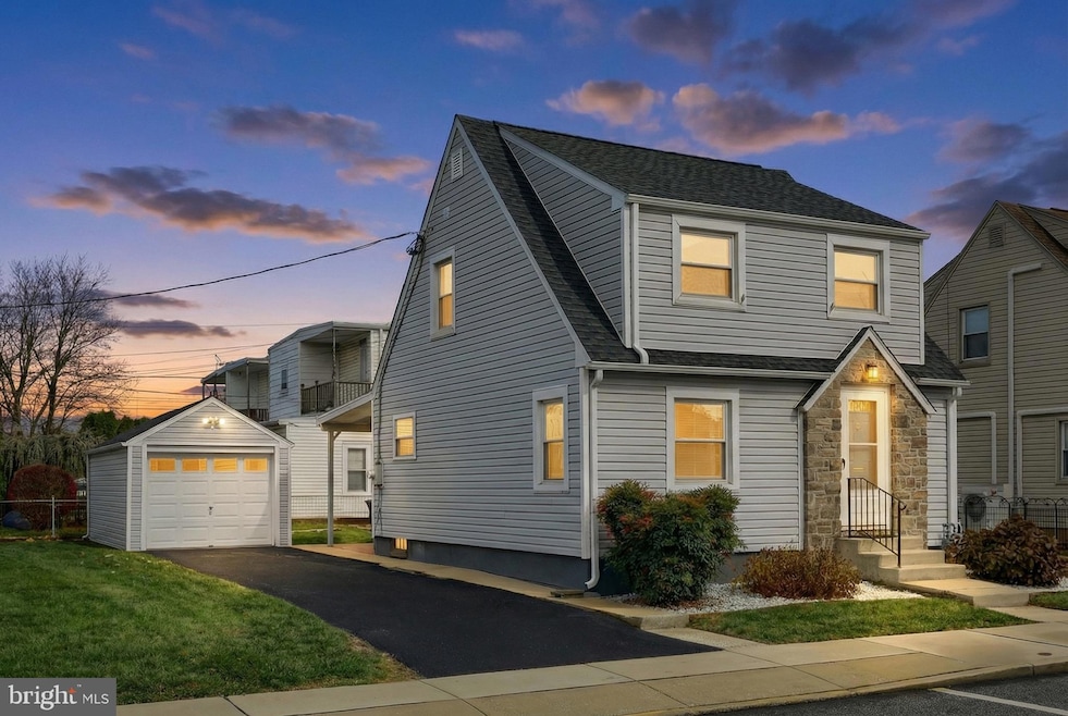
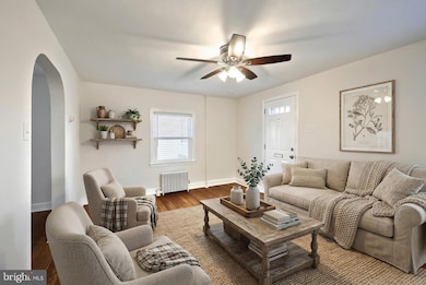
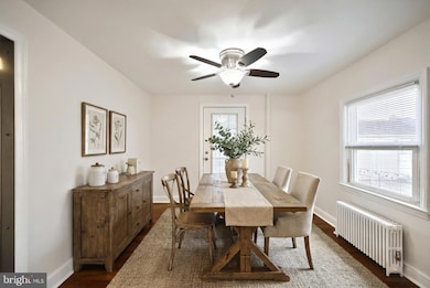
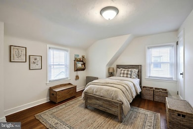
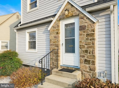
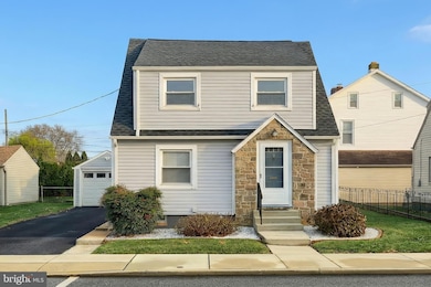
**Virtually Staged** Welcome home to a place that feels just right from the moment you step inside. This charming two-bedroom, one-bath colonial in the heart of West York offers over 900 square feet of thoughtfully cared-for space, perfect for anyone looking to start fresh, downsize, or step into their very first home. The main level features an inviting open layout where sunlight flows easily from room to room, highlighting the freshly painted walls and beautifully refinished hardwood floors. Both bedrooms offer cozy, comfortable retreats, and the updated bathroom blends modern convenience with timeless charm. Whether you’re hosting friends, enjoying a quiet evening in, or beginning new traditions, this warm and inviting home makes everything feel effortless.
Step out back to a spacious porch designed for slow mornings, cozy dinners, and peaceful moments outdoors. Beyond it sits a small yet surprisingly spacious-feeling backyard, easy to maintain, but with enough room to garden, grill, or simply unwind. A detached garage adds everyday convenience, and all included appliances make settling in refreshingly simple. With central heating, ceiling fans, and a brand-new roof installed in 2024, comfort and peace of mind come built in.
Downstairs, an unfinished basement offers excellent storage now with potential for future finishing, an ideal opportunity for a hobby room, home gym, or added living space whenever you’re ready.
Set in one of West York’s friendliest, most down-to-earth neighborhoods, this home places you in a community known for its affordability and genuine small-town warmth. Here, neighbors wave, local businesses feel familiar, and everything you need, parks, dining, grocery stores, and daily conveniences, is just minutes away. With easy access to major routes and a short commute to York City, you’ll enjoy the perfect balance of peaceful living and everyday practicality.
For first-time buyers or anyone seeking a cozy, manageable home with room to grow, this property offers the kind of beginning people hope for, comfortable, charming, and full of possibility. With its blend of character, modern updates, and a welcoming community, this home isn’t just a place to live, it’s a place to truly belong.
Listing Agent
(717) 668-4694 nathanbarsh.realestate@gmail.com EXP Realty, LLC License #RS359935 Listed on: 11/21/2025

Open House Schedule
-
Saturday, November 29, 202511:00 am to 1:00 pm11/29/2025 11:00:00 AM +00:0011/29/2025 1:00:00 PM +00:00Add to Calendar
Home Details
Home Type
- Single Family
Est. Annual Taxes
- $3,623
Year Built
- Built in 1940 | Remodeled in 2024
Lot Details
- 2,479 Sq Ft Lot
- Property is in excellent condition
Parking
- 1 Car Detached Garage
- Front Facing Garage
Home Design
- Colonial Architecture
- Permanent Foundation
- Vinyl Siding
Interior Spaces
- Property has 2 Levels
- Ceiling Fan
- Wood Flooring
- Stove
- Unfinished Basement
Bedrooms and Bathrooms
- 2 Main Level Bedrooms
- 1 Full Bathroom
Laundry
- Dryer
- Washer
Accessible Home Design
- More Than Two Accessible Exits
Schools
- West York Area High School
Utilities
- Window Unit Cooling System
- Central Heating
- Hot Water Heating System
- Natural Gas Water Heater
Community Details
- No Home Owners Association
- West York Boro Subdivision
Listing and Financial Details
- Tax Lot 0011
- Assessor Parcel Number 88-000-14-0011-B0-00000
Map
Home Values in the Area
Average Home Value in this Area
Tax History
| Year | Tax Paid | Tax Assessment Tax Assessment Total Assessment is a certain percentage of the fair market value that is determined by local assessors to be the total taxable value of land and additions on the property. | Land | Improvement |
|---|---|---|---|---|
| 2025 | $3,660 | $73,240 | $20,890 | $52,350 |
| 2024 | $3,360 | $73,240 | $20,890 | $52,350 |
| 2023 | $3,268 | $73,240 | $20,890 | $52,350 |
| 2022 | $3,085 | $73,240 | $20,890 | $52,350 |
| 2021 | $3,012 | $73,240 | $20,890 | $52,350 |
| 2020 | $3,012 | $73,240 | $20,890 | $52,350 |
| 2019 | $2,895 | $73,240 | $20,890 | $52,350 |
| 2018 | $2,821 | $73,240 | $20,890 | $52,350 |
| 2017 | $2,748 | $73,240 | $20,890 | $52,350 |
| 2016 | $0 | $73,240 | $20,890 | $52,350 |
| 2015 | -- | $73,240 | $20,890 | $52,350 |
| 2014 | -- | $73,240 | $20,890 | $52,350 |
Property History
| Date | Event | Price | List to Sale | Price per Sq Ft |
|---|---|---|---|---|
| 11/21/2025 11/21/25 | Price Changed | $225,000 | +12.5% | $234 / Sq Ft |
| 11/21/2025 11/21/25 | For Sale | $200,000 | -- | $208 / Sq Ft |
Purchase History
| Date | Type | Sale Price | Title Company |
|---|---|---|---|
| Executors Deed | $120,000 | None Listed On Document | |
| Deed | $52,000 | -- | |
| Quit Claim Deed | -- | -- |
Mortgage History
| Date | Status | Loan Amount | Loan Type |
|---|---|---|---|
| Open | $90,000 | New Conventional |
Source: Bright MLS
MLS Number: PAYK2094052
APN: 88-000-14-0011.B0-00000
Disclaimer: Certain information contained herein is derived from information provided by parties other than Homes.com. All information provided is deemed reliable, but is not guaranteed to be accurate and should be independently verified.
![]() The data relating to real estate for sale on this website appears in part through the BRIGHT Internet Data Exchange program, a voluntary cooperative exchange of property listing data between licensed real estate brokerage firms, and is provided by BRIGHT through a licensing agreement.
The data relating to real estate for sale on this website appears in part through the BRIGHT Internet Data Exchange program, a voluntary cooperative exchange of property listing data between licensed real estate brokerage firms, and is provided by BRIGHT through a licensing agreement.
Listing information is from various brokers who participate in the Bright MLS IDX program and not all listings may be visible on the site.
The property information being provided on or through the website is for the personal, non-commercial use of consumers and such information may not be used for any purpose other than to identify prospective properties consumers may be interested in purchasing.
Some properties which appear for sale on the website may no longer be available because they are for instance, under contract, sold or are no longer being offered for sale.
Property information displayed is deemed reliable but is not guaranteed.
Copyright 2025 Bright MLS, Inc.
- 114 N Seward St
- 109 N Seward St
- 1609 Stanton St
- 1562 Filbert St
- 1635 Stanton St
- 1622 W Philadelphia St
- 19 N Seward St
- 26 N Highland Ave
- 1745 Filbert Rear St Unit REAR
- 1420 W Market St
- 39 S Sumner St
- 1802 Filbert St
- 46 N Clinton St
- 1635 Monroe St
- 504 N Highland Ave
- 1825 W Philadelphia St
- 1601 Bannister St
- 1431 W King St
- 1437 W King St
- 1925 W Philadelphia St
- 1422 W Market St
- 1336 W Philadelphia St Unit 1ST FLOOR
- 50 S Highland Ave
- 1 Heiges Ave Unit GARAGE 4
- 1134 W King St Unit 2
- 933 Linden Ave Unit 1
- 700 Linden Ave
- 719 W Philadelphia St Unit 1
- 702 W Philadelphia St Unit 2
- 1038 Roosevelt Ave
- 76 Lark Cir
- 1 Lark Cir
- 433 Linden Ave Unit 1
- 130 Hull Dr
- 424 Linden Ave Unit 1ST FLOOR FRONT
- 442 W Market St Unit 1
- 1269 Elderslie Ln
- 1060 Crest Way
- 875 Fahs St
- 419 N Newberry St Unit 1ST FLOOR