
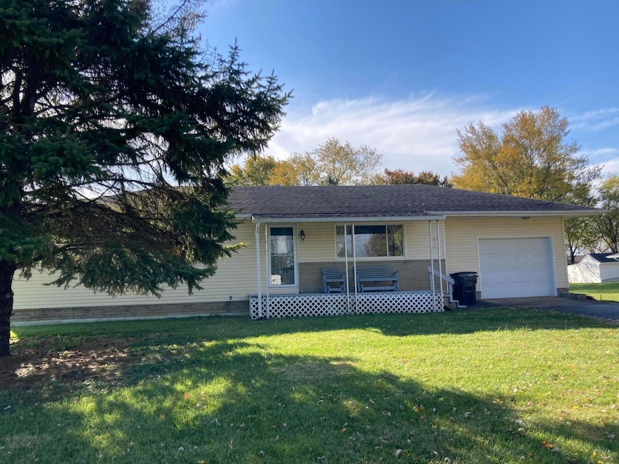


1565 State Route 665 London, OH 43140
Estimated payment $1,745/month
Total Views
631
3
Beds
1
Bath
1,246
Sq Ft
$241
Price per Sq Ft
Highlights
- 1.01 Acre Lot
- Wood Flooring
- Screened Porch
- Ranch Style House
- No HOA
- 1 Car Attached Garage
About This Home
Enjoy being close to town but in a country setting in this 3 bedroom ranch home on a full basement. Gas furnace and water heater, C/A 4 years old, enclosed porch, 1 car attached garage, and 10X16 shed on an acre! Fantastic built-in in hallway and a laundry chute!
Home Details
Home Type
- Single Family
Est. Annual Taxes
- $1,973
Year Built
- Built in 1961
Lot Details
- 1.01 Acre Lot
Parking
- 1 Car Attached Garage
- Garage Door Opener
Home Design
- Ranch Style House
- Block Foundation
- Vinyl Siding
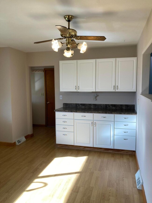
Interior Spaces
- 1,246 Sq Ft Home
- Screened Porch
- Basement Fills Entire Space Under The House
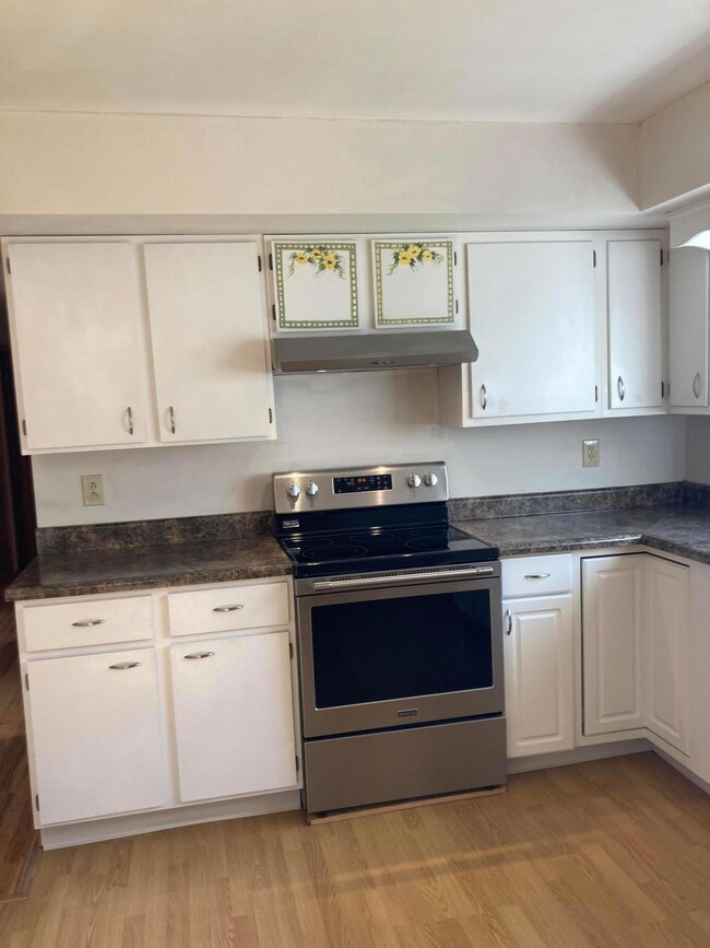
Kitchen
- Electric Range
- Dishwasher
Flooring
- Wood
- Laminate
Bedrooms and Bathrooms
- 3 Main Level Bedrooms
- 1 Full Bathroom
Laundry
- Laundry on lower level
- Electric Dryer Hookup
Outdoor Features
- Shed
- Storage Shed
Utilities
- Forced Air Heating and Cooling System
- Heating System Uses Gas
- Well
- Gas Water Heater
- Private Sewer
Community Details
- No Home Owners Association
Listing and Financial Details
- Assessor Parcel Number 29-00502.000
Map
Create a Home Valuation Report for This Property
The Home Valuation Report is an in-depth analysis detailing your home's value as well as a comparison with similar homes in the area
Home Values in the Area
Average Home Value in this Area
Tax History
| Year | Tax Paid | Tax Assessment Tax Assessment Total Assessment is a certain percentage of the fair market value that is determined by local assessors to be the total taxable value of land and additions on the property. | Land | Improvement |
|---|---|---|---|---|
| 2024 | $1,973 | $58,170 | $13,910 | $44,260 |
| 2023 | $1,973 | $58,170 | $13,910 | $44,260 |
| 2022 | $1,926 | $48,370 | $11,560 | $36,810 |
| 2021 | $1,505 | $48,370 | $11,560 | $36,810 |
| 2020 | $1,507 | $48,370 | $11,560 | $36,810 |
| 2019 | $1,280 | $43,440 | $13,370 | $30,070 |
| 2018 | $1,280 | $43,440 | $13,370 | $30,070 |
| 2017 | $1,256 | $43,440 | $13,370 | $30,070 |
| 2016 | $975 | $38,630 | $13,370 | $25,260 |
| 2015 | $967 | $38,630 | $13,370 | $25,260 |
| 2014 | $967 | $38,630 | $13,370 | $25,260 |
| 2013 | -- | $40,670 | $11,390 | $29,280 |
Source: Public Records
Property History
| Date | Event | Price | List to Sale | Price per Sq Ft |
|---|---|---|---|---|
| 11/05/2025 11/05/25 | For Sale | $299,900 | -- | $241 / Sq Ft |
Source: Columbus and Central Ohio Regional MLS
Purchase History
| Date | Type | Sale Price | Title Company |
|---|---|---|---|
| Warranty Deed | $103,700 | Landsel Title | |
| Interfamily Deed Transfer | -- | Landsel Title | |
| Warranty Deed | $60,000 | Midland Title | |
| Warranty Deed | -- | None Available |
Source: Public Records
Mortgage History
| Date | Status | Loan Amount | Loan Type |
|---|---|---|---|
| Open | $123,000 | New Conventional |
Source: Public Records
About the Listing Agent
Lisa's Other Listings
Source: Columbus and Central Ohio Regional MLS
MLS Number: 225041979
APN: 29-00502.000
Disclaimer: Certain information contained herein is derived from information provided by parties other than Homes.com. All information provided is deemed reliable, but is not guaranteed to be accurate and should be independently verified.
![]() IDX information is provided exclusively for personal, non-commercial use, and may not be used for any purpose other than to identify prospective properties consumers may be interested in purchasing.
IDX information is provided exclusively for personal, non-commercial use, and may not be used for any purpose other than to identify prospective properties consumers may be interested in purchasing.
Information is deemed reliable but not guaranteed.
Nearby Homes
- 307 Nixon Way
- 103 Andrew Ct E
- 37 Birchwood Dr
- 321 Bishop Dr
- 473 Samantha Cir Unit 53
- 15 Stewart Ave
- 438 Samantha Cir Unit 3
- 35 E Lincoln Ave
- 154 E High St
- 144 E High St
- 18 W Center St
- 1061 Edinburgh Cove
- 44 E 4th St Unit 46
- 121 W Center St
- 1028 Amherst Blvd
- 0 Keny Blvd Unit 225008830
- 661 Ohio 38
- 161 Western Ave
- 186 W Center St
- 40 S Cherry St
- 302 Muirwood Dr
- 1004 Lindsey Loop
- 1073-1090 Claudia Dr
- 1154 Stratford Way
- 809 Dozer Dr
- 98 N Franklin St
- 156 S Chester St Unit 156 S. Chester St.
- 429 Red Elderberry Dr
- 13587 S Charleston Pike
- 1021 Okatie Dr
- 6334 Oak Trail Dr
- 70 N London St Unit 70 N London st
- 950 Brushfield Dr
- 6160 Hall Rd
- 915 Galloway Rd
- 280 Alton Darby Creek Rd
- 750 Nicklaus Blvd
- 1719 Ringfield Dr
- 270 Cloverhill Dr
- 1056 Leclerc Place