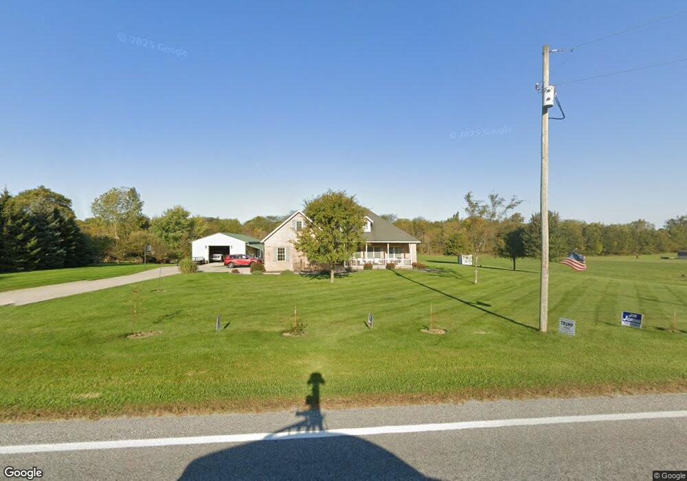
15653 State Route 67 Wapakoneta, OH 45895
Estimated Value: $488,000 - $580,000
3
Beds
3
Baths
1,803
Sq Ft
$303/Sq Ft
Est. Value
About This Home
This home is located at 15653 State Route 67, Wapakoneta, OH 45895 and is currently estimated at $545,452, approximately $302 per square foot. 15653 State Route 67 is a home located in Auglaize County with nearby schools including Wapakoneta Elementary School, Wapakoneta High School, and Wapakoneta Middle School.
Ownership History
Date
Name
Owned For
Owner Type
Purchase Details
Closed on
Aug 7, 2012
Sold by
Holyzapple Keith B and Holtzapple Jerrilee A
Bought by
Douglas Justin L and Cox Cassandra L
Current Estimated Value
Home Financials for this Owner
Home Financials are based on the most recent Mortgage that was taken out on this home.
Original Mortgage
$250,381
Outstanding Balance
$174,103
Interest Rate
3.75%
Mortgage Type
FHA
Estimated Equity
$371,349
Purchase Details
Closed on
Jan 26, 2004
Sold by
Hut Edward J
Bought by
Holtzapple Keith B
Purchase Details
Closed on
Nov 15, 2002
Bought by
Hut Edward J
Create a Home Valuation Report for This Property
The Home Valuation Report is an in-depth analysis detailing your home's value as well as a comparison with similar homes in the area
Home Values in the Area
Average Home Value in this Area
Purchase History
| Date | Buyer | Sale Price | Title Company |
|---|---|---|---|
| Douglas Justin L | $255,000 | Lorain County Title Company | |
| Holtzapple Keith B | $37,000 | -- | |
| Hut Edward J | $23,100 | -- |
Source: Public Records
Mortgage History
| Date | Status | Borrower | Loan Amount |
|---|---|---|---|
| Open | Douglas Justin L | $250,381 |
Source: Public Records
Tax History Compared to Growth
Tax History
| Year | Tax Paid | Tax Assessment Tax Assessment Total Assessment is a certain percentage of the fair market value that is determined by local assessors to be the total taxable value of land and additions on the property. | Land | Improvement |
|---|---|---|---|---|
| 2024 | $7,373 | $148,210 | $21,010 | $127,200 |
| 2023 | $4,924 | $148,210 | $21,010 | $127,200 |
| 2022 | $3,926 | $108,930 | $17,510 | $91,420 |
| 2021 | $3,906 | $108,930 | $17,510 | $91,420 |
| 2020 | $3,915 | $108,927 | $17,507 | $91,420 |
| 2019 | $3,333 | $89,285 | $14,350 | $74,935 |
| 2018 | $3,344 | $89,285 | $14,350 | $74,935 |
| 2017 | $3,325 | $89,285 | $14,350 | $74,935 |
| 2016 | $3,036 | $81,946 | $13,668 | $68,278 |
| 2015 | $3,034 | $81,946 | $13,668 | $68,278 |
| 2014 | $3,016 | $81,946 | $13,668 | $68,278 |
| 2013 | $3,093 | $81,946 | $13,668 | $68,278 |
Source: Public Records
Map
Nearby Homes
- 15639 State Route 67
- 15642 State Route 67
- 15633 State Route 67
- 15725 State Route 67
- 15771 State Route 67
- 15789 State Route 67
- 15821 State Route 67
- 15835 State Route 67
- 15835 Ohio 67
- 15608 Blackhoof Creek Rd
- 15590 Blackhoof Creek Rd
- 15769 Blackhoof Creek Rd
- 15863 State Route 67
- 15668 Blackhoof Creek Rd
- 15766 Blackhoof Creek Rd
- 15468 State Route 67
- 15867 State Route 67
- 15468 Ohio 67