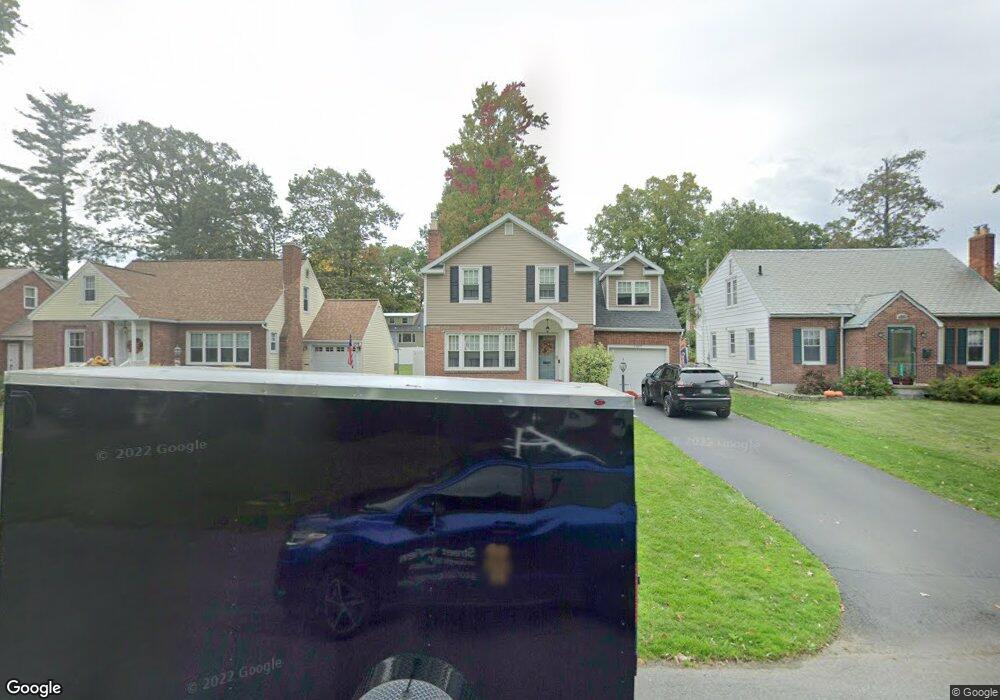
1567 Kingston Ave Schenectady, NY 12309
Estimated Value: $303,000 - $387,000
3
Beds
3
Baths
1,710
Sq Ft
$194/Sq Ft
Est. Value
About This Home
This home is located at 1567 Kingston Ave, Schenectady, NY 12309 and is currently estimated at $331,206, approximately $193 per square foot. 1567 Kingston Ave is a home located in Schenectady County with nearby schools including Jessie T Zoller School, Oneida Middle School, and Schenectady High School.
Ownership History
Date
Name
Owned For
Owner Type
Purchase Details
Closed on
Mar 5, 2019
Sold by
Musso Mary E
Bought by
Caruso Angela M
Current Estimated Value
Home Financials for this Owner
Home Financials are based on the most recent Mortgage that was taken out on this home.
Original Mortgage
$169,750
Outstanding Balance
$149,239
Interest Rate
4.4%
Mortgage Type
New Conventional
Estimated Equity
$181,967
Purchase Details
Closed on
Oct 25, 1995
Sold by
Rivlin Raymond and Rivlin Helen B
Bought by
Musso Mary E
Create a Home Valuation Report for This Property
The Home Valuation Report is an in-depth analysis detailing your home's value as well as a comparison with similar homes in the area
Home Values in the Area
Average Home Value in this Area
Purchase History
| Date | Buyer | Sale Price | Title Company |
|---|---|---|---|
| Caruso Angela M | $175,000 | None Available | |
| Musso Mary E | $85,000 | -- |
Source: Public Records
Mortgage History
| Date | Status | Borrower | Loan Amount |
|---|---|---|---|
| Open | Caruso Angela M | $169,750 |
Source: Public Records
Tax History Compared to Growth
Tax History
| Year | Tax Paid | Tax Assessment Tax Assessment Total Assessment is a certain percentage of the fair market value that is determined by local assessors to be the total taxable value of land and additions on the property. | Land | Improvement |
|---|---|---|---|---|
| 2024 | $7,121 | $154,800 | $24,900 | $129,900 |
| 2023 | $7,121 | $154,800 | $24,900 | $129,900 |
| 2022 | $7,136 | $154,800 | $24,900 | $129,900 |
| 2021 | $7,102 | $154,800 | $24,900 | $129,900 |
| 2020 | $7,002 | $154,800 | $24,900 | $129,900 |
| 2019 | $3,795 | $154,800 | $24,900 | $129,900 |
| 2018 | $6,358 | $154,800 | $24,900 | $129,900 |
| 2017 | $2,968 | $154,800 | $24,900 | $129,900 |
| 2016 | $7,087 | $165,800 | $24,900 | $140,900 |
| 2015 | -- | $165,800 | $24,900 | $140,900 |
| 2014 | -- | $165,800 | $24,900 | $140,900 |
Source: Public Records
Map
Nearby Homes
- 1509 Wyoming Ave
- 1537 Kingston Ave
- 1579 Belmont Ave
- 1524 Baker Ave
- 1461 Grenoside Ave
- 1450 Grenoside Ave
- 1474 Baker Ave
- 1556 Dean St
- 1563 Grand Blvd
- 1912 Dean St
- 1470 Nott St
- 1922 Regent St
- 1415 Baker Ave
- 2209 Niskayuna Dr
- 2040 Baker Ave
- 1250 Sumner Ave
- 1369 Baker Ave
- 2032 Hoover Rd
- 1245 Sumner Ave
- 1304 Baker Ave
- 1573 Kingston Ave
- 1563 Kingston Ave
- 1575 Kingston Ave
- 1559 Kingston Ave
- 1577 Kingston Ave
- 1581 Kingston Ave
- 1520 Wyoming Ave
- 1555 Kingston Ave
- 1528 Wyoming Ave
- 1536 Wyoming Ave
- 1512 Wyoming Ave
- 1568 Kingston Ave
- 1562 Kingston Ave
- 1558 Kingston Ave
- 1551 Kingston Ave
- 1544 Wyoming Ave
- 1570 Kingston Ave
- 1585 Kingston Ave
- 1500 Wyoming Ave
- 1556 Kingston Ave