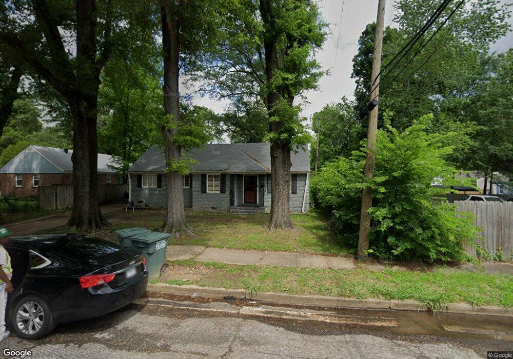
1568 Michael St Memphis, TN 38111
Colonial Acres NeighborhoodEstimated Value: $111,000 - $133,000
About This Home
This home is located at 1568 Michael St, Memphis, TN 38111 and is currently estimated at $123,462, approximately $94 per square foot. 1568 Michael St is a home located in Shelby County with nearby schools including South Park Elementary School, Colonial Middle, and Overton High.
Ownership History
We collect this data history from publicly available records. To have your information removed, we recommend requesting removal directly through your county’s website.
Purchase Details
Purchase Details
Home Financials for this Owner
Home Financials are based on the most recent Mortgage that was taken out on this home.Purchase Details
Purchase Details
Home Financials for this Owner
Home Financials are based on the most recent Mortgage that was taken out on this home.Purchase Details
Purchase Details
Purchase Details
Purchase Details
Purchase Details
Purchase Details
Home Financials for this Owner
Home Financials are based on the most recent Mortgage that was taken out on this home.Home Values in the Area
Average Home Value in this Area
Purchase History
We collect this data history from publicly available records. To have your information removed, we recommend requesting removal directly through your county’s website.
| Date | Buyer | Sale Price | Title Company |
|---|---|---|---|
| -- | None Listed On Document | ||
| -- | Fidelity National Title | ||
| -- | Saddle Creek Title Llc | ||
| $79,000 | Saddle Creek Title Llc | ||
| $29,000 | Saddle Creek Title Llc | ||
| -- | None Available | ||
| -- | None Available | ||
| -- | None Available | ||
| $13,000 | None Available | ||
| $28,500 | Landcastle Title Llc | ||
| $66,114 | None Available | ||
| $77,500 | Multiple |
Mortgage History
We collect this data history from publicly available records. To have your information removed, we recommend requesting removal directly through your county’s website.
| Date | Status | Borrower | Loan Amount |
|---|---|---|---|
| Previous Owner | $117,750 | ||
| Previous Owner | $63,200 | ||
| Previous Owner | $77,500 | ||
| Closed | $0 |
Tax History
We collect this data history from publicly available records. To have your information removed, we recommend requesting removal directly through your county’s website.
| Year | Tax Paid | Tax Assessment Tax Assessment Total Assessment is a certain percentage of the fair market value that is determined by local assessors to be the total taxable value of land and additions on the property. | Land | Improvement |
|---|---|---|---|---|
| 2025 | $906 | $33,675 | $5,000 | $28,675 |
| 2024 | $739 | $21,800 | $2,900 | $18,900 |
| 2023 | $1,328 | $21,800 | $2,900 | $18,900 |
| 2022 | $1,328 | $21,800 | $2,900 | $18,900 |
| 2021 | $1,344 | $21,800 | $2,900 | $18,900 |
| 2020 | $1,245 | $17,175 | $2,650 | $14,525 |
| 2019 | $549 | $17,175 | $2,650 | $14,525 |
| 2018 | $549 | $17,175 | $2,650 | $14,525 |
| 2017 | $471 | $14,400 | $2,650 | $11,750 |
| 2016 | $619 | $14,175 | $0 | $0 |
| 2014 | $619 | $14,175 | $0 | $0 |
Map
- 1597 Michael St
- 4187 Boyce Ave
- 4208 Vann Ave
- 4223 Kimball Ave
- 4059 New Willow Rd
- 4242 Fredericks Ave
- 4254 Fredericks Ave
- 1563 Flamingo Rd
- 4055 Kimball Ave
- 4402 Boyce Rd
- 4436 Boyce Rd
- 4089 Meadow Dr
- 4401 Quince Rd
- 3917 Dunn Ave
- 4491 Dunn Ave
- 1284 Merrycrest Dr
- 1809 Cherry Rd
- 4487 E Dearing Rd
- 1305 Cherry Rd
- 1744 Dearing Rd
- 4189 Atwood Ave
- 4199 Atwood Ave
- 4190 Boyce Ave
- 4196 Boyce Ave
- 4202 Boyce Ave
- 4205 Atwood Ave
- 4206 Boyce Ave
- 1567 Michael St
- 1575 Michael St
- 4211 Atwood Ave
- 1559 Michael St
- 4188 Atwood Ave
- 4212 Boyce Ave
- 1583 Michael St
- 4198 Atwood Ave
- 1553 Michael St
- 4216 Boyce Ave
- 4219 Atwood Ave
- 4204 Atwood Ave
- 1542 Michael St
Ask me questions while you tour the home.