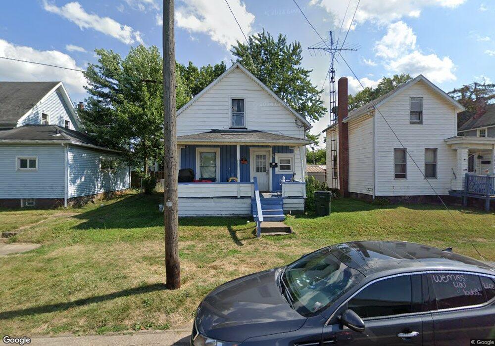
157 E Ely St Alliance, OH 44601
Estimated Value: $64,000 - $88,000
2
Beds
2
Baths
898
Sq Ft
$82/Sq Ft
Est. Value
About This Home
This home is located at 157 E Ely St, Alliance, OH 44601 and is currently estimated at $73,775, approximately $82 per square foot. 157 E Ely St is a home located in Stark County with nearby schools including Alliance Early Learning School, Alliance Intermediate School at Northside, and Alliance Middle School.
Ownership History
Date
Name
Owned For
Owner Type
Purchase Details
Closed on
Apr 21, 2000
Sold by
Burden Tracy L
Bought by
Burden James L
Current Estimated Value
Purchase Details
Closed on
Aug 16, 1996
Sold by
Burden Grace
Bought by
Burden James L and Burden Tracy
Home Financials for this Owner
Home Financials are based on the most recent Mortgage that was taken out on this home.
Original Mortgage
$14,450
Outstanding Balance
$1,139
Interest Rate
8.18%
Mortgage Type
New Conventional
Estimated Equity
$72,636
Create a Home Valuation Report for This Property
The Home Valuation Report is an in-depth analysis detailing your home's value as well as a comparison with similar homes in the area
Home Values in the Area
Average Home Value in this Area
Purchase History
| Date | Buyer | Sale Price | Title Company |
|---|---|---|---|
| Burden James L | -- | -- | |
| Burden James L | $14,940 | -- |
Source: Public Records
Mortgage History
| Date | Status | Borrower | Loan Amount |
|---|---|---|---|
| Open | Burden James L | $14,450 |
Source: Public Records
Tax History
| Year | Tax Paid | Tax Assessment Tax Assessment Total Assessment is a certain percentage of the fair market value that is determined by local assessors to be the total taxable value of land and additions on the property. | Land | Improvement |
|---|---|---|---|---|
| 2025 | $220 | $5,150 | $2,030 | $3,120 |
| 2024 | $84 | $5,150 | $2,030 | $3,120 |
| 2023 | $168 | $3,720 | $1,020 | $2,700 |
| 2022 | $154 | $3,720 | $1,020 | $2,700 |
| 2021 | $155 | $3,720 | $1,020 | $2,700 |
| 2020 | $137 | $3,090 | $740 | $2,350 |
| 2019 | $136 | $3,090 | $740 | $2,350 |
| 2018 | $136 | $3,090 | $740 | $2,350 |
| 2017 | $744 | $2,630 | $630 | $2,000 |
| 2016 | $587 | $2,630 | $630 | $2,000 |
| 2015 | $126 | $2,630 | $630 | $2,000 |
| 2014 | $135 | $2,810 | $670 | $2,140 |
| 2013 | $67 | $2,810 | $670 | $2,140 |
Source: Public Records
Map
Nearby Homes
- 710 N Freedom Ave
- 505 N Union Ave
- 62 E Market St
- 361 E Main St
- 171 1/2 W Main St
- 163 W Market St
- 849 Walnut Ave
- V/L S Freedom Ave
- 427 S Union Ave
- 847 E Patterson St
- 264 W Market St
- 717 Garfield Ave
- 33 S Lincoln Ave
- 118 S Mckinley Ave
- 442 S Liberty Ave
- 343 W Columbia St
- 1015 Reed St
- 228 W Oxford St
- 1025 Reed St
- 452 E Summit St
- 151 E Ely St
- 256 N Mechanic Ave
- 248 N Mechanic Ave
- 143 E Ely St
- 135 E Ely St
- 230 N Mechanic Ave
- 133 E Ely St
- 0 Mechanic #47-49-51
- 105 E Ely St
- 104 E Ely St
- 411 Hester Ave
- 319 N Park Ave
- 320 Hester Ave
- 131 E Harrison St
- 409 Hester Ave
- 419 Crawford Ct
- 429 Hester Ave
- 256 N Park Ave
- 70 E Ely St
- 431 Hester Ave
Your Personal Tour Guide
Ask me questions while you tour the home.