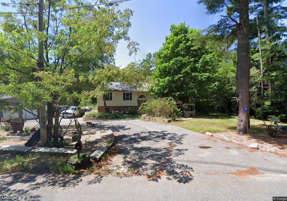
157 Hazard Rd West Greenwich, RI 02817
Estimated Value: $400,000 - $502,066
3
Beds
2
Baths
1,190
Sq Ft
$378/Sq Ft
Est. Value
About This Home
This home is located at 157 Hazard Rd, West Greenwich, RI 02817 and is currently estimated at $449,767, approximately $377 per square foot. 157 Hazard Rd is a home located in Kent County with nearby schools including Mildred E. Lineham School, Metcalf School, and Wawaloam School.
Ownership History
Date
Name
Owned For
Owner Type
Purchase Details
Closed on
Jan 23, 2017
Sold by
Nsp Residential Llc
Bought by
Estrela Oliverio M
Current Estimated Value
Home Financials for this Owner
Home Financials are based on the most recent Mortgage that was taken out on this home.
Original Mortgage
$214,000
Outstanding Balance
$176,406
Interest Rate
4.13%
Mortgage Type
Purchase Money Mortgage
Estimated Equity
$273,361
Purchase Details
Closed on
Jan 22, 2015
Sold by
Estrela Oliverio M
Bought by
Us Bank Na
Purchase Details
Closed on
Aug 16, 2005
Sold by
Johnson Kathleen T and Johnson Edward W
Bought by
Estrela Oliverio M
Purchase Details
Closed on
Jul 23, 2004
Sold by
William A Miller Assoc
Bought by
Johnson Kathleen T and Johnson Edward W
Create a Home Valuation Report for This Property
The Home Valuation Report is an in-depth analysis detailing your home's value as well as a comparison with similar homes in the area
Home Values in the Area
Average Home Value in this Area
Purchase History
| Date | Buyer | Sale Price | Title Company |
|---|---|---|---|
| Estrela Oliverio M | $210,400 | -- | |
| Nsp Residential Llc | $170,000 | -- | |
| Us Bank Na | $199,750 | -- | |
| Estrela Oliverio M | $325,000 | -- | |
| Johnson Kathleen T | $284,000 | -- |
Source: Public Records
Mortgage History
| Date | Status | Borrower | Loan Amount |
|---|---|---|---|
| Open | Johnson Kathleen T | $214,000 | |
| Closed | Johnson Kathleen T | $214,000 | |
| Previous Owner | Johnson Kathleen T | $282,400 |
Source: Public Records
Tax History Compared to Growth
Tax History
| Year | Tax Paid | Tax Assessment Tax Assessment Total Assessment is a certain percentage of the fair market value that is determined by local assessors to be the total taxable value of land and additions on the property. | Land | Improvement |
|---|---|---|---|---|
| 2024 | $7,157 | $447,300 | $150,500 | $296,800 |
| 2023 | $6,900 | $281,500 | $116,700 | $164,800 |
| 2022 | $6,900 | $281,500 | $116,700 | $164,800 |
| 2021 | $6,764 | $281,500 | $116,700 | $164,800 |
| 2020 | $6,697 | $281,500 | $116,700 | $164,800 |
| 2019 | $7,198 | $297,800 | $126,300 | $171,500 |
| 2018 | $4,867 | $290,400 | $133,900 | $156,500 |
| 2017 | $6,549 | $290,400 | $133,900 | $156,500 |
| 2016 | $5,229 | $231,900 | $104,900 | $127,000 |
| 2015 | $5,229 | $231,900 | $104,900 | $127,000 |
| 2013 | $5,286 | $234,400 | $103,900 | $130,500 |
Source: Public Records
Map
Nearby Homes
- 29 Bailey Pond Rd
- 112 Bailey Pond Rd
- 445 Plain Rd
- 453 Plain Rd
- 31 Wickaboxet Dr
- 410 Porter Pond Rd
- 367 Pine Hill Rd
- 532 Lewis Farm Rd
- 01 Stubble Brook Rd
- 176 Hopkins Hollow Rd
- 295 Hopkins Hollow Rd
- 126 Pine Hill Rd
- 64 Knight View Dr
- 953 Ekonk Hill Rd
- 18 Ledge Hill Rd
- 211 Victory Hwy
- 581 Sterling Rd
- 234 John Potter Rd
- 47 N Shore Rd
- 19 N Shore Rd