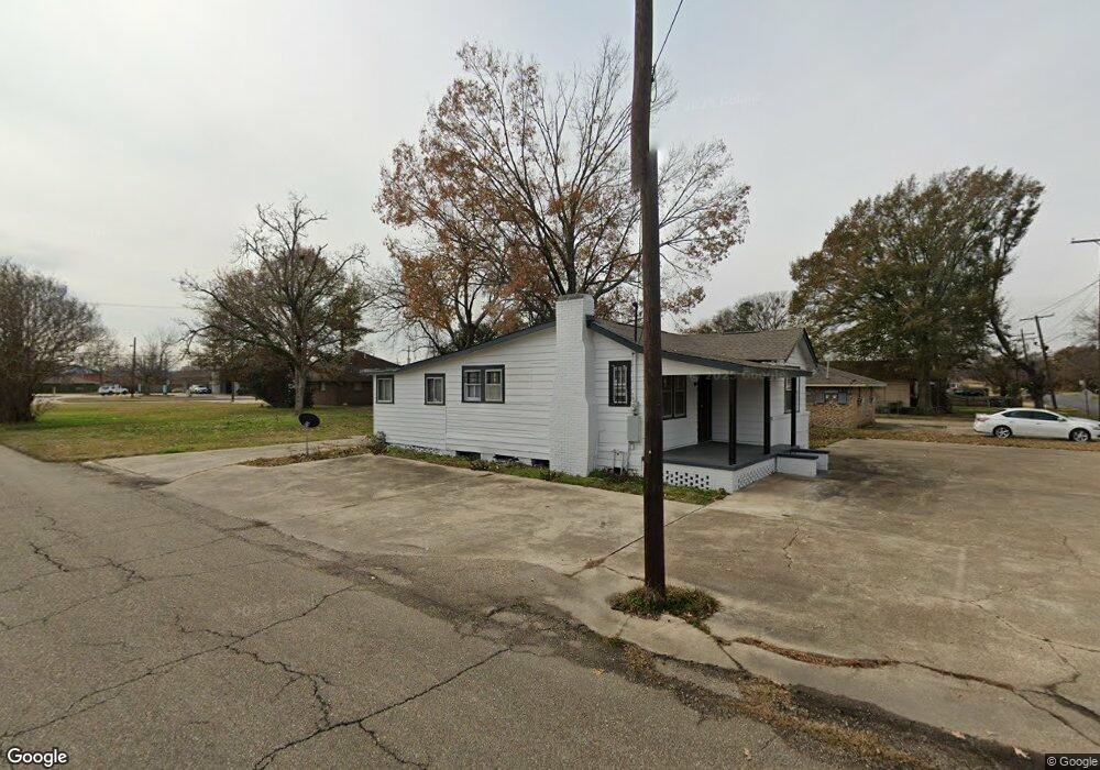
1570 Curtis St Baton Rouge, LA 70807
Scotlandville NeighborhoodEstimated Value: $49,000 - $81,358
3
Beds
2
Baths
1,288
Sq Ft
$53/Sq Ft
Est. Value
About This Home
This home is located at 1570 Curtis St, Baton Rouge, LA 70807 and is currently estimated at $68,590, approximately $53 per square foot. 1570 Curtis St is a home located in East Baton Rouge Parish with nearby schools including Progress Elementary School, Scotlandville Magnet High School, and J. K. Haynes Charter Inc..
Ownership History
Date
Name
Owned For
Owner Type
Purchase Details
Closed on
Apr 29, 2024
Sold by
Berry Clint A
Bought by
Williams Karen Jenine
Current Estimated Value
Purchase Details
Closed on
Apr 26, 2024
Sold by
Banks Chad and Banks Brandy
Bought by
Berry Clint A
Purchase Details
Closed on
Mar 30, 2022
Sold by
Jackson Bonnie Square & Laura S
Bought by
Berry Clint A and Berry Dominque
Home Financials for this Owner
Home Financials are based on the most recent Mortgage that was taken out on this home.
Original Mortgage
$38,000
Interest Rate
3.89%
Mortgage Type
New Conventional
Create a Home Valuation Report for This Property
The Home Valuation Report is an in-depth analysis detailing your home's value as well as a comparison with similar homes in the area
Home Values in the Area
Average Home Value in this Area
Purchase History
| Date | Buyer | Sale Price | Title Company |
|---|---|---|---|
| Williams Karen Jenine | $47,000 | Titleplus | |
| Berry Clint A | -- | None Listed On Document | |
| Berry Clint A | $32,933 | None Listed On Document |
Source: Public Records
Mortgage History
| Date | Status | Borrower | Loan Amount |
|---|---|---|---|
| Previous Owner | Berry Clint A | $38,000 |
Source: Public Records
Tax History Compared to Growth
Tax History
| Year | Tax Paid | Tax Assessment Tax Assessment Total Assessment is a certain percentage of the fair market value that is determined by local assessors to be the total taxable value of land and additions on the property. | Land | Improvement |
|---|---|---|---|---|
| 2024 | $349 | $2,980 | $190 | $2,790 |
| 2023 | $349 | $2,960 | $170 | $2,790 |
| 2022 | $270 | $2,260 | $170 | $2,090 |
| 2021 | $264 | $2,260 | $170 | $2,090 |
| 2020 | $262 | $2,260 | $170 | $2,090 |
| 2019 | $248 | $2,050 | $150 | $1,900 |
| 2018 | $245 | $2,050 | $150 | $1,900 |
| 2017 | $245 | $2,050 | $150 | $1,900 |
| 2016 | $239 | $2,050 | $150 | $1,900 |
| 2015 | $233 | $2,000 | $150 | $1,850 |
| 2014 | $233 | $2,000 | $150 | $1,850 |
| 2013 | -- | $2,000 | $150 | $1,850 |
Source: Public Records
Map
Nearby Homes
- 1582 Snipe St
- 1124 Simms St
- LOT 16 Owl Ave
- LOT 15 Owl Ave
- LOT 14 Owl Ave
- 1060 Swan Ave
- LOT 12 Swan Ave
- LOT 9 Swan Ave
- LOT 2+ Osprey Ave
- LOT 4 Osprey Ave
- LOT 5 Osprey Ave
- LOT 6 Osprey Ave
- LOT 7-A Osprey Ave
- LOT 8-A Osprey Ave
- 2116 Fairchild St
- 0 Stilt St
- 1535 Stilt St
- 0 Cardinal St
- 1257 Cardinal St
- 2188 75th Ave
- 1554 Curtis St Unit A
- 1554/1556 Curtis St
- 1556 Curtis St
- 1610 Curtis St
- 1618 Curtis St
- 1538 Curtis St
- 1526 Curtis St
- 1630 Curtis St
- 1615 Curtis St
- 1520 Curtis St
- 1635 Curtis St
- 1642 Curtis St
- 1655 Harding Blvd
- 1655 Harding Blvd
- 1655 Harding Blvd
- 1531 Harding Blvd
- 1515 Harding Blvd
- 1654 Curtis St
- 1620 Fairchild St
- 1634 Fairchild St