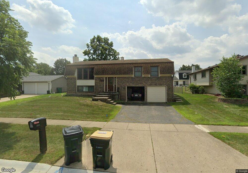
1571 Colorado Ln Elk Grove Village, IL 60007
Elk Grove Village West NeighborhoodEstimated Value: $399,000 - $493,000
4
Beds
2
Baths
1,248
Sq Ft
$355/Sq Ft
Est. Value
About This Home
This home is located at 1571 Colorado Ln, Elk Grove Village, IL 60007 and is currently estimated at $443,199, approximately $355 per square foot. 1571 Colorado Ln is a home located in Cook County with nearby schools including Adolph Link Elementary School, Margaret Mead Junior High School, and J B Conant High School.
Ownership History
Date
Name
Owned For
Owner Type
Purchase Details
Closed on
Jun 16, 2025
Sold by
Smolik Robert K and Smolik Elizabeth J
Bought by
Robert And Elizabeth Smolik Joint Living Trus and Smolik
Current Estimated Value
Purchase Details
Closed on
Apr 30, 2004
Sold by
Defrancesco Philip D and Ruggiero Michelle M
Bought by
Smolik Robert K and Smolik Elizabeth J
Home Financials for this Owner
Home Financials are based on the most recent Mortgage that was taken out on this home.
Original Mortgage
$230,000
Interest Rate
6.46%
Mortgage Type
Unknown
Purchase Details
Closed on
Jun 8, 1998
Sold by
Bola Alexander J and Horvath Karyn M
Bought by
Defrancesco Philip D and Defrancesco Michelle M
Home Financials for this Owner
Home Financials are based on the most recent Mortgage that was taken out on this home.
Original Mortgage
$91,000
Interest Rate
7.22%
Create a Home Valuation Report for This Property
The Home Valuation Report is an in-depth analysis detailing your home's value as well as a comparison with similar homes in the area
Home Values in the Area
Average Home Value in this Area
Purchase History
| Date | Buyer | Sale Price | Title Company |
|---|---|---|---|
| Robert And Elizabeth Smolik Joint Living Trus | -- | None Listed On Document | |
| Smolik Robert K | $300,000 | Atgf Inc | |
| Defrancesco Philip D | $185,000 | -- |
Source: Public Records
Mortgage History
| Date | Status | Borrower | Loan Amount |
|---|---|---|---|
| Previous Owner | Smolik Robert K | $230,000 | |
| Previous Owner | Defrancesco Philip D | $91,000 |
Source: Public Records
Tax History Compared to Growth
Tax History
| Year | Tax Paid | Tax Assessment Tax Assessment Total Assessment is a certain percentage of the fair market value that is determined by local assessors to be the total taxable value of land and additions on the property. | Land | Improvement |
|---|---|---|---|---|
| 2024 | $8,079 | $31,126 | $6,615 | $24,511 |
| 2023 | $8,421 | $33,235 | $6,615 | $26,620 |
| 2022 | $8,421 | $33,235 | $6,615 | $26,620 |
| 2021 | $6,813 | $24,739 | $5,670 | $19,069 |
| 2020 | $6,709 | $24,739 | $5,670 | $19,069 |
| 2019 | $6,804 | $27,797 | $5,670 | $22,127 |
| 2018 | $5,717 | $21,737 | $4,914 | $16,823 |
| 2017 | $5,673 | $21,737 | $4,914 | $16,823 |
| 2016 | $5,545 | $21,737 | $4,914 | $16,823 |
| 2015 | $5,817 | $21,393 | $4,158 | $17,235 |
| 2014 | $5,757 | $21,393 | $4,158 | $17,235 |
| 2013 | $5,591 | $21,393 | $4,158 | $17,235 |
Source: Public Records
Map
Nearby Homes
- 665 Arizona Pass
- 713 Oklahoma Way
- 1771 Vermont Dr
- 1517 White Trail
- 1385 Scarboro Rd Unit 204
- 1386 Scarboro Rd Unit 1102
- 307 University Ln Unit A
- 391 Thornhill Ct Unit B1
- 263 Doral Ct Unit 1
- 870 Debra Ln
- 402 Sandalwood Ln Unit C1
- 375 Pinetree Ln Unit D-1
- 373 Southbury Ct Unit D-1
- 1845 Maryland Dr
- 327 Wildberry Ct Unit D2
- 1910 Baltimore Dr
- 797 Geneva Cir
- 1124 Lovell Ct
- 1221 Plum Tree Ct Unit 5481RD
- 274 Buckingham Ct Unit D2
- 1575 Colorado Ln
- 1569 Colorado Ln
- 1570 Nevada Ln
- 1574 Nevada Ln
- 1568 Nevada Ln
- 1581 Colorado Ln
- 1565 Colorado Ln
- 1570 Colorado Ln
- 1578 Nevada Ln
- 1574 Colorado Ln
- 1568 Colorado Ln
- 1564 Nevada Ln
- 1578 Colorado Ln
- 1561 Colorado Ln
- 1585 Colorado Ln
- 1564 Colorado Ln
- 1582 Nevada Ln
- 705 Utah St
- 1558 Nevada Ln
- 1571 California St