Estimated Value: $247,000 - $265,000
3
Beds
2
Baths
1,572
Sq Ft
$161/Sq Ft
Est. Value
About This Home
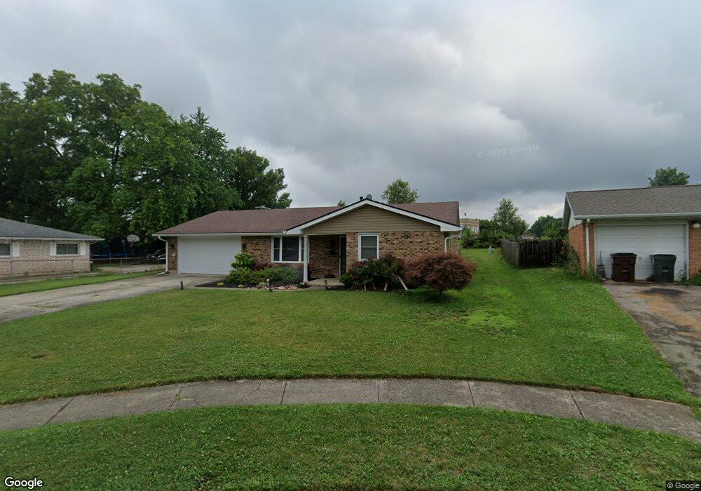
This home is located at 1572 Wigwam Trail, Xenia, OH 45385 and is currently estimated at $253,181, approximately $161 per square foot. 1572 Wigwam Trail is a home located in Greene County with nearby schools including Xenia High School, Summit Academy Community School for Alternative Learners - Xenia, and Legacy Christian Academy.
Ownership History
Date
Name
Owned For
Owner Type
Purchase Details
Closed on
Sep 9, 2020
Sold by
Allison Katie and Allison Shaun M
Bought by
Moore Daniel L and Moore Erin B
Current Estimated Value
Purchase Details
Closed on
Jun 4, 2019
Sold by
Alco Properties Llc
Bought by
Allison Katie
Home Financials for this Owner
Home Financials are based on the most recent Mortgage that was taken out on this home.
Original Mortgage
$149,380
Interest Rate
4.1%
Mortgage Type
Future Advance Clause Open End Mortgage
Purchase Details
Closed on
Feb 28, 2018
Sold by
Dehaven Corey
Bought by
Alco Properties Llc
Purchase Details
Closed on
Aug 28, 2017
Bought by
Dehaven Diana K
Create a Home Valuation Report for This Property
The Home Valuation Report is an in-depth analysis detailing your home's value as well as a comparison with similar homes in the area
Home Values in the Area
Average Home Value in this Area
Purchase History
| Date | Buyer | Sale Price | Title Company |
|---|---|---|---|
| Moore Daniel L | $169,900 | None Available | |
| Allison Katie | $154,000 | First Ohio Title Insurance | |
| Alco Properties Llc | $74,300 | First Ohio Title | |
| Dehaven Diana K | -- | -- |
Source: Public Records
Mortgage History
| Date | Status | Borrower | Loan Amount |
|---|---|---|---|
| Previous Owner | Allison Katie | $149,380 |
Source: Public Records
Tax History Compared to Growth
Tax History
| Year | Tax Paid | Tax Assessment Tax Assessment Total Assessment is a certain percentage of the fair market value that is determined by local assessors to be the total taxable value of land and additions on the property. | Land | Improvement |
|---|---|---|---|---|
| 2024 | $3,208 | $74,980 | $12,370 | $62,610 |
| 2023 | $3,208 | $74,980 | $12,370 | $62,610 |
| 2022 | $2,712 | $54,050 | $7,280 | $46,770 |
| 2021 | $2,748 | $45,450 | $7,280 | $38,170 |
| 2020 | $2,214 | $45,450 | $7,280 | $38,170 |
| 2019 | $1,840 | $35,550 | $7,080 | $28,470 |
| 2018 | $1,847 | $35,550 | $7,080 | $28,470 |
| 2017 | $1,793 | $35,550 | $7,080 | $28,470 |
| 2016 | $1,676 | $31,650 | $7,080 | $24,570 |
| 2015 | $1,680 | $31,650 | $7,080 | $24,570 |
| 2014 | $1,609 | $31,650 | $7,080 | $24,570 |
Source: Public Records
Map
Nearby Homes
- 1272 Bellbrook Ave
- 1208 Bellbrook Ave
- 1778 Arapaho Dr
- 1144 Rockwell Dr
- 1618 Navajo Dr
- 1653 Seneca Dr
- 1568 Cheyenne Dr
- 1769 Gayhart Dr
- 1342 Kylemore Dr
- 1866 Roxbury Dr
- 1829 Gayhart Dr
- 1908 Whitt St
- 1283 June Dr
- 1233 June Dr
- 1223 June Dr
- 1391 June Dr
- 2758 Wyoming Dr
- 1255 Colorado Dr
- 121 S Progress Dr
- 1107 Arkansas Dr
- 1590 Wigwam Trail
- 1564 Wigwam Trail
- 1602 Wigwam Trail
- 1556 Wigwam Trail
- 1583 Wigwam Trail
- 1550 Wigwam Trail
- 1616 Wigwam Trail
- 1540 Wigwam Trail
- 1589 Arrowhead Trail
- 1565 Arrowhead Trail
- 1613 Wigwam Trail
- 1628 Wigwam Trail
- 1553 Arrowhead Trail
- 1526 Wigwam Trail
- 1541 Arrowhead Trail
- 964 Moccasin Trail
- 1627 Wigwam Trail
- 980 Moccasin Trail
- 1642 Wigwam Trail
- 934 Moccasin Trail