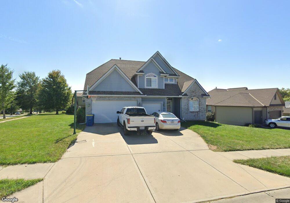
1573 Bernadine Dr Liberty, MO 64068
Estimated Value: $465,556 - $552,000
4
Beds
3
Baths
2,740
Sq Ft
$184/Sq Ft
Est. Value
About This Home
This home is located at 1573 Bernadine Dr, Liberty, MO 64068 and is currently estimated at $504,639, approximately $184 per square foot. 1573 Bernadine Dr is a home located in Clay County with nearby schools including Alexander Doniphan Elementary School, Liberty Middle School, and Liberty High School.
Ownership History
Date
Name
Owned For
Owner Type
Purchase Details
Closed on
Jul 29, 2020
Sold by
Shaw Jason E and Shaw Adrianne J
Bought by
Shaw Jason E and Shaw Adrianne J
Current Estimated Value
Home Financials for this Owner
Home Financials are based on the most recent Mortgage that was taken out on this home.
Original Mortgage
$237,993
Outstanding Balance
$211,117
Interest Rate
3%
Mortgage Type
FHA
Estimated Equity
$293,522
Purchase Details
Closed on
Dec 12, 2019
Sold by
Shaw Jason E and Shaw Adrianne A
Bought by
Shaw Jason E and Shaw Adrianne A
Purchase Details
Closed on
Jun 10, 2005
Sold by
Shaw Jason E and Shaw Jason
Bought by
Shaw Jason and Shaw Adrianne
Home Financials for this Owner
Home Financials are based on the most recent Mortgage that was taken out on this home.
Original Mortgage
$242,000
Interest Rate
5.95%
Mortgage Type
Stand Alone Refi Refinance Of Original Loan
Purchase Details
Closed on
Oct 15, 2003
Sold by
Derek Alan Custom Homes Llc
Bought by
Shaw Jason E
Home Financials for this Owner
Home Financials are based on the most recent Mortgage that was taken out on this home.
Original Mortgage
$223,200
Interest Rate
8.95%
Mortgage Type
Purchase Money Mortgage
Purchase Details
Closed on
Oct 1, 2002
Sold by
South Liberty Development Llc
Bought by
Derek Alan Custom Homes Llc
Home Financials for this Owner
Home Financials are based on the most recent Mortgage that was taken out on this home.
Original Mortgage
$231,000
Interest Rate
6.26%
Create a Home Valuation Report for This Property
The Home Valuation Report is an in-depth analysis detailing your home's value as well as a comparison with similar homes in the area
Home Values in the Area
Average Home Value in this Area
Purchase History
| Date | Buyer | Sale Price | Title Company |
|---|---|---|---|
| Shaw Jason E | -- | Stewart Title Company | |
| Shaw Jason E | -- | Stewart Title Company | |
| Shaw Jason | -- | Multiple | |
| Shaw Jason E | -- | Thomson Title Corporation | |
| Derek Alan Custom Homes Llc | -- | United Title Company Inc |
Source: Public Records
Mortgage History
| Date | Status | Borrower | Loan Amount |
|---|---|---|---|
| Open | Shaw Jason E | $237,993 | |
| Closed | Shaw Jason | $242,000 | |
| Closed | Shaw Jason E | $223,200 | |
| Previous Owner | Derek Alan Custom Homes Llc | $231,000 |
Source: Public Records
Tax History Compared to Growth
Tax History
| Year | Tax Paid | Tax Assessment Tax Assessment Total Assessment is a certain percentage of the fair market value that is determined by local assessors to be the total taxable value of land and additions on the property. | Land | Improvement |
|---|---|---|---|---|
| 2025 | $5,356 | $78,220 | -- | -- |
| 2024 | $5,356 | $69,640 | -- | -- |
| 2023 | $5,447 | $69,640 | $0 | $0 |
| 2022 | $4,689 | $59,190 | $0 | $0 |
| 2021 | $4,652 | $59,185 | $7,980 | $51,205 |
| 2020 | $4,607 | $55,040 | $0 | $0 |
| 2019 | $4,606 | $55,040 | $0 | $0 |
| 2018 | $4,468 | $52,420 | $0 | $0 |
| 2017 | $4,316 | $52,420 | $6,650 | $45,770 |
| 2016 | $4,316 | $51,110 | $6,650 | $44,460 |
| 2015 | $4,316 | $51,110 | $6,650 | $44,460 |
| 2014 | $4,191 | $49,230 | $7,220 | $42,010 |
Source: Public Records
Map
Nearby Homes
- 1991 Harvest Rd
- 1841 Vintage Ln
- 1845 Arbor Trail
- 1852 Vintage Ln
- 1836 Green Meadow Dr
- 1912 Longview Dr
- 1985 Longview Dr
- 1916 Longview Dr
- 1989 Longview Dr
- 1856 Arbor Trail
- 1975 Harvest Rd
- 1979 Harvest Rd
- 1971 Harvest Rd
- 2188 Heritage Ct
- 1205 Blackberry Dr
- McKinley Plan at Homestead of Liberty - Homestead
- Monroe Plan at Homestead of Liberty - Homestead
- Chestnut Plan at Homestead of Liberty - Homestead
- The Brooklyn Plan at Homestead of Liberty - Homestead
- Cypress Plan at Homestead of Liberty - Homestead
- 1577 Bernadine Dr
- 1900 Parkside Dr
- 1910 Parkside Dr
- 1601 Bernadine Dr
- 1566 Bernadine Dr
- 1841 Buckingham Dr
- 1837 Buckingham Dr
- 1576 Bernadine Dr
- 1920 Parkside Dr
- 1833 Buckingham Dr
- 1699 Bernadine Dr
- 1590 Bernadine Dr
- 1600 Bernadine Dr
- 1571 Carriage Ct
- 1901 Parkside Dr
- 1838 Parkside Dr
- 1909 Parkside Dr
- 1563 Carriage Cir
- 1575 Carriage Ct
- 1926 Parkside Dr