Estimated Value: $489,000 - $634,000
6
Beds
3
Baths
3,720
Sq Ft
$144/Sq Ft
Est. Value
About This Home
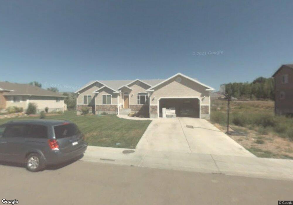
This home is located at 1578 W 550 N, Price, UT 84501 and is currently estimated at $537,073, approximately $144 per square foot. 1578 W 550 N is a home located in Carbon County with nearby schools including Creekview School, Mont Harmon Junior High School, and Carbon High School.
Ownership History
Date
Name
Owned For
Owner Type
Purchase Details
Closed on
Sep 19, 2023
Sold by
Dart Greg and Dart Dawn
Bought by
Mathis Michael Wayne and Mathis Jennifer Stathis
Current Estimated Value
Home Financials for this Owner
Home Financials are based on the most recent Mortgage that was taken out on this home.
Original Mortgage
$185,000
Outstanding Balance
$175,839
Interest Rate
6.96%
Mortgage Type
New Conventional
Estimated Equity
$361,234
Purchase Details
Closed on
Aug 5, 2019
Sold by
Vandyke Kerry and Vandyke Sherene
Bought by
Dart Greg and Dart Dawn
Home Financials for this Owner
Home Financials are based on the most recent Mortgage that was taken out on this home.
Original Mortgage
$250,000
Interest Rate
3.8%
Mortgage Type
New Conventional
Create a Home Valuation Report for This Property
The Home Valuation Report is an in-depth analysis detailing your home's value as well as a comparison with similar homes in the area
Home Values in the Area
Average Home Value in this Area
Purchase History
| Date | Buyer | Sale Price | Title Company |
|---|---|---|---|
| Mathis Michael Wayne | -- | Professional Title | |
| Mathis Michael Wayne | -- | Professional Title | |
| Dart Greg | -- | Professional Title Services |
Source: Public Records
Mortgage History
| Date | Status | Borrower | Loan Amount |
|---|---|---|---|
| Open | Mathis Michael Wayne | $185,000 | |
| Closed | Mathis Michael Wayne | $185,000 | |
| Previous Owner | Dart Greg | $250,000 |
Source: Public Records
Tax History Compared to Growth
Tax History
| Year | Tax Paid | Tax Assessment Tax Assessment Total Assessment is a certain percentage of the fair market value that is determined by local assessors to be the total taxable value of land and additions on the property. | Land | Improvement |
|---|---|---|---|---|
| 2025 | $3,361 | $260,253 | $30,291 | $229,962 |
| 2024 | $3,251 | $256,078 | $34,045 | $222,033 |
| 2023 | $3,241 | $275,716 | $24,750 | $250,966 |
| 2022 | $3,219 | $242,447 | $27,468 | $214,980 |
| 2021 | $2,976 | $355,494 | $40,275 | $315,219 |
| 2020 | $2,600 | $155,755 | $0 | $0 |
| 2019 | $1,891 | $138,555 | $0 | $0 |
| 2018 | $1,839 | $138,555 | $0 | $0 |
| 2017 | $1,824 | $139,411 | $0 | $0 |
| 2016 | $1,631 | $139,411 | $0 | $0 |
| 2015 | $1,631 | $139,411 | $0 | $0 |
| 2014 | $1,607 | $139,411 | $0 | $0 |
| 2013 | $1,621 | $139,411 | $0 | $0 |
Source: Public Records
Map
Nearby Homes
- 1335 W Evergreen Dr
- 1189 W 290 N
- 126 N Balsam Way
- 109 N 1470 (Balsam Way) W
- 420 N Josephine Ln W
- 401 N Fairgrounds Rd
- 830 N 2140 W
- 2 Hilltop
- 702 W 1150 N Unit 4
- 670 W 1150 N
- 1643 N Mountain States Rd
- 275 N 500 W
- 1433 W 2060 N
- 1177 W 2060 N
- 495 S Fairgrounds Rd
- 82 W 200 N
- 240 N Carbon Ave
- 1240 W 2360 N
- 280 W 500 S
- 175 N 100 E