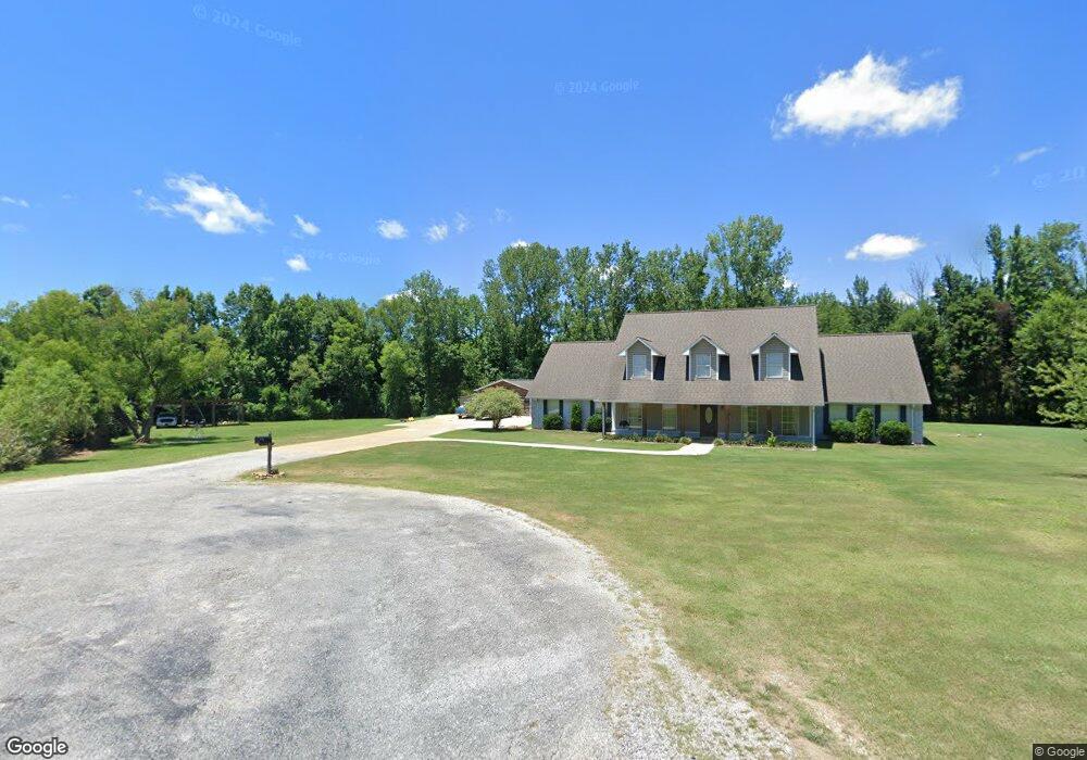
158 Carroll Rd Saltillo, MI 38866
Estimated Value: $431,000 - $479,000
6
Beds
5
Baths
3,649
Sq Ft
$125/Sq Ft
Est. Value
About This Home
This home is located at 158 Carroll Rd, Saltillo, MI 38866 and is currently estimated at $454,939, approximately $124 per square foot. 158 Carroll Rd is a home located in Lee County with nearby schools including Saltillo Primary School, Saltillo Elementary School, and Guntown Middle School.
Ownership History
Date
Name
Owned For
Owner Type
Purchase Details
Closed on
Aug 10, 2016
Sold by
Cobb Michael and Harmon Karen
Bought by
Mckinney Daniel and Mckinney Rebecca
Current Estimated Value
Home Financials for this Owner
Home Financials are based on the most recent Mortgage that was taken out on this home.
Original Mortgage
$185,250
Outstanding Balance
$147,118
Interest Rate
3.42%
Mortgage Type
Purchase Money Mortgage
Estimated Equity
$307,821
Purchase Details
Closed on
Nov 24, 2014
Bought by
Chadwick Michael
Purchase Details
Closed on
Apr 25, 2007
Sold by
Hopkins Chuck and Hopkins Sherry
Bought by
Frank Sarah K and Winters Jonahtan
Home Financials for this Owner
Home Financials are based on the most recent Mortgage that was taken out on this home.
Original Mortgage
$256,500
Interest Rate
6.11%
Create a Home Valuation Report for This Property
The Home Valuation Report is an in-depth analysis detailing your home's value as well as a comparison with similar homes in the area
Purchase History
| Date | Buyer | Sale Price | Title Company |
|---|---|---|---|
| Mckinney Daniel | -- | -- | |
| Chadwick Michael | -- | -- | |
| Frank Sarah K | -- | -- |
Source: Public Records
Mortgage History
| Date | Status | Borrower | Loan Amount |
|---|---|---|---|
| Open | Mckinney Daniel | $185,250 | |
| Previous Owner | Frank Sarah K | $256,500 |
Source: Public Records
Tax History
| Year | Tax Paid | Tax Assessment Tax Assessment Total Assessment is a certain percentage of the fair market value that is determined by local assessors to be the total taxable value of land and additions on the property. | Land | Improvement |
|---|---|---|---|---|
| 2025 | $3,832 | $35,546 | $0 | $0 |
| 2024 | $3,832 | $35,546 | $0 | $0 |
| 2023 | $2,233 | $20,813 | $0 | $0 |
| 2022 | $1,933 | $20,813 | $0 | $0 |
| 2021 | $1,933 | $20,813 | $0 | $0 |
| 2020 | $2,237 | $20,813 | $0 | $0 |
| 2019 | $1,800 | $19,467 | $0 | $0 |
| 2018 | $1,816 | $19,467 | $0 | $0 |
| 2017 | $1,774 | $19,467 | $0 | $0 |
| 2016 | $1,705 | $19,467 | $0 | $0 |
| 2015 | $1,639 | $18,922 | $0 | $0 |
| 2014 | $1,639 | $18,922 | $0 | $0 |
Source: Public Records
Map
Nearby Homes
- 139 Drive 2322
- 0 Lot7 Hunter's Ridge Euclatubba Rd
- 0 Lot6 Hunter's Ridge Euclatubba Rd
- 115 Larry Webb St
- 0 0 Long Ave
- 0 12 3 Acres Long Ave
- 121 Northfield Dr
- 154 Cathryn Dr
- 1056 County Road 833
- 373 County Road 951
- 125 Saint Thomas Dr
- 0 County Road 681 Unit Lot 3
- 0 County Road 681 Unit Lot 4
- 0 County Road 681 Unit Lot 5
- 0 County Road 681 Unit Lot 2
- 111 Deanna Dr
- 187 Megs Ln
- 191 Greenhill Dr
- 210 Pam Ave
- 149 Megs Ln
Your Personal Tour Guide
Ask me questions while you tour the home.