
158 Kates Path Yarmouth Port, MA 02675
Yarmouth Port NeighborhoodEstimated payment $5,384/month
Highlights
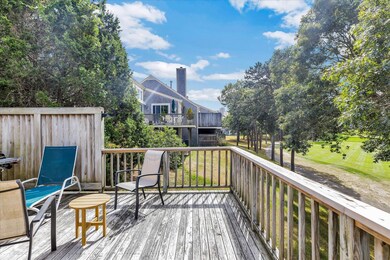
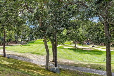
- On Golf Course
- Recreation Room
- Main Floor Primary Bedroom
- Deck
- Wood Flooring
- 1 Fireplace
About This Home
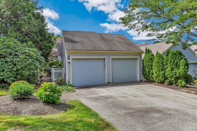
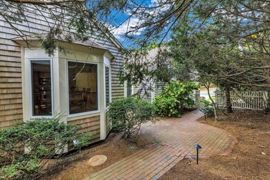
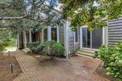
Stunning end unit at King's Way in Yarmouthport with sweeping views of the 12th fairway. Move-in ready and filled with natural light, this home offers 1st-floor living with a spacious primary suite, full bath, and convenient laundry. High-end kitchen with granite countertops, stainless appliances and full sized dining area. Hardwood floors and gas fireplace add warmth and charm. Beautiful living room with vaulted ceilings and recessed lighting. The 2nd floor features a second bedroom, full bath, and lofted office. The walk-out lower level includes a third bedroom, full bath, living area, and storage. The 2-car attached garage offers direct access. Enjoy relaxing outside on the large back deck overlooking the golf course. Located north of 6A, King's Way is a beautifully maintained community with outdoor heated pools, tennis/pickle ball courts, walking trails, and lush grounds. Enjoy the Meeting House, Social Center/Post Office, and year-round activities. Just 3 miles to Grey's Beach and 4 to Mayflower, with easy access to shopping, dining, and Route 6.
Listing Agent
Cape Coastal Sotheby's International Realty License #9550171 Listed on: 09/23/2025

Townhouse Details
Home Type
- Townhome
Est. Annual Taxes
- $4,796
Year Built
- Built in 1994
Lot Details
- On Golf Course
- End Unit
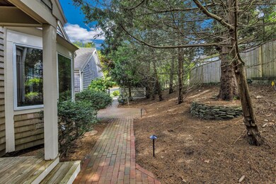
- Landscaped
HOA Fees
- $900 Monthly HOA Fees
Parking
- 2 Car Attached Garage
- Open Parking
Home Design
- Asphalt Roof
- Shingle Siding
Interior Spaces
- 2,688 Sq Ft Home
- 3-Story Property
- 1 Fireplace
- Recreation Room
Kitchen
- Gas Range
- Microwave
- Dishwasher
Flooring
- Wood
- Carpet
- Tile
Bedrooms and Bathrooms
- 3 Bedrooms
- Primary Bedroom on Main
Laundry
- Laundry Room
- Laundry on main level
- Washer
Finished Basement
- Basement Fills Entire Space Under The House
- Interior Basement Entry
Outdoor Features
- Deck
- Patio
Location
- Property is near shops
Utilities
- Central Air
- Heating Available
- Electric Water Heater
Listing and Financial Details
- Assessor Parcel Number 1421C158
Community Details
Overview
- Association fees include professional property management
- 456 Units
Amenities
- Common Area
Recreation
- Snow Removal
Map
Home Values in the Area
Average Home Value in this Area
Tax History
| Year | Tax Paid | Tax Assessment Tax Assessment Total Assessment is a certain percentage of the fair market value that is determined by local assessors to be the total taxable value of land and additions on the property. | Land | Improvement |
|---|---|---|---|---|
| 2025 | $4,233 | $597,900 | $0 | $597,900 |
| 2024 | $4,395 | $595,500 | $0 | $595,500 |
| 2023 | $4,047 | $499,000 | $0 | $499,000 |
| 2022 | $4,621 | $503,400 | $0 | $503,400 |
| 2021 | $4,498 | $470,500 | $0 | $470,500 |
| 2020 | $4,540 | $454,000 | $0 | $454,000 |
| 2019 | $4,259 | $421,700 | $0 | $421,700 |
| 2018 | $4,008 | $389,500 | $0 | $389,500 |
| 2017 | $3,740 | $373,300 | $0 | $373,300 |
| 2016 | $3,565 | $357,200 | $0 | $357,200 |
| 2015 | $3,570 | $355,600 | $0 | $355,600 |
Property History
| Date | Event | Price | List to Sale | Price per Sq Ft |
|---|---|---|---|---|
| 10/10/2025 10/10/25 | Pending | -- | -- | -- |
| 09/23/2025 09/23/25 | For Sale | $775,000 | -- | $288 / Sq Ft |
Purchase History
| Date | Type | Sale Price | Title Company |
|---|---|---|---|
| Land Court Massachusetts | $440,000 | -- | |
| Land Court Massachusetts | $337,000 | -- | |
| Leasehold Conv With Agreement Of Sale Fee Purchase Hawaii | $210,000 | -- |
Mortgage History
| Date | Status | Loan Amount | Loan Type |
|---|---|---|---|
| Previous Owner | $269,600 | Purchase Money Mortgage |
Source: Cape Cod & Islands Association of REALTORS®
MLS Number: 22504730
APN: YARM-000142-000001-000158-C000000
Disclaimer: Certain information contained herein is derived from information provided by parties other than Homes.com. All information provided is deemed reliable, but is not guaranteed to be accurate and should be independently verified.
![]() All data relating to real estate for sale on this page comes from the Broker Reciprocity (BR) of the Cape Cod & Islands Multiple Listing Service, Inc. Detailed information about real estate listings held by brokerage firms other than CC&I Assoc. of REALTORS®, Inc. includes the name of the listing company. Neither the listing company nor CC&I Assoc. of REALTORS®, Inc. shall be responsible for any typographical errors, misinformation, misprints and shall be held totally harmless. The Broker providing this data believes it to be correct, but advises interested parties to confirm any item before relying on it in a purchase decision. All properties are subject to prior sale, changes, or withdrawal. Copyright 2025 © Cape Cod & Islands Multiple Listing Service, Inc. All rights reserved.
All data relating to real estate for sale on this page comes from the Broker Reciprocity (BR) of the Cape Cod & Islands Multiple Listing Service, Inc. Detailed information about real estate listings held by brokerage firms other than CC&I Assoc. of REALTORS®, Inc. includes the name of the listing company. Neither the listing company nor CC&I Assoc. of REALTORS®, Inc. shall be responsible for any typographical errors, misinformation, misprints and shall be held totally harmless. The Broker providing this data believes it to be correct, but advises interested parties to confirm any item before relying on it in a purchase decision. All properties are subject to prior sale, changes, or withdrawal. Copyright 2025 © Cape Cod & Islands Multiple Listing Service, Inc. All rights reserved.
- 30 W Woods
- 228 Kates Path
- 30 W Woods Cir Unit 30
- 7 Forest Gate Unit 7
- 17 Kates Path Unit A
- 50 John Hall Cartway
- 50 John Hall Cartway Unit 50
- 42 John Hall Cartway Unit 42
- 34 Kates Path
- 34 Kates Path Unit 34
- 64 Kates Path
- 28 Oak Glen
- 2 Pine Grove
- 25 Oak Glen Village Unit 25
- 25 Oak Glen
- 43 Canterbury Rd
- 44 Stratford Ln
- 21 Boxwood Cir
- 51 Bray Farm Rd N
- 1 Barnacle Rd