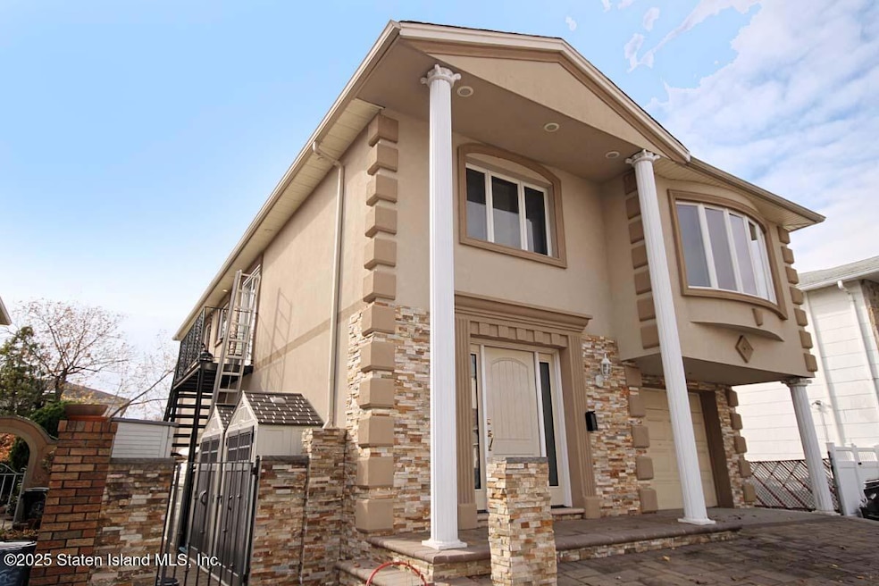


158 Malone Ave Staten Island, NY 10306
Oakwood NeighborhoodEstimated payment $7,958/month
Highlights
- Eat-In Kitchen
- Cooling Available
- Combination Dining and Living Room
- P.S. 53 The Barbara Esselborn School Rated A
- Forced Air Heating System
About This Home
Beautiful two family high ranch located in the heart of Oakwood. Only steps away from transportation to the city. House is beautifully maintained with lots of extra room. Motivated seller willing to hear offers.
Property Details
Home Type
- Multi-Family
Est. Annual Taxes
- $8,382
Year Built
- Built in 1975
Lot Details
- 4,500 Sq Ft Lot
- Lot Dimensions are 45 x 100
Parking
- 1 Car Garage
- On-Street Parking
- Off-Street Parking
Home Design
- Duplex
- Stone Siding
- Stucco
Interior Spaces
- 2,677 Sq Ft Home
- 2-Story Property
- Combination Dining and Living Room
- Eat-In Kitchen
Bedrooms and Bathrooms
- 5 Bedrooms
- Primary Bathroom is a Full Bathroom
Utilities
- Cooling Available
- Forced Air Heating System
- Heating System Uses Natural Gas
- 220 Volts
- Individual Gas Meter
Community Details
- 2 Units
Listing and Financial Details
- Legal Lot and Block 0029 / 04720
- Assessor Parcel Number 04720-0029
Map
Home Values in the Area
Average Home Value in this Area
Tax History
| Year | Tax Paid | Tax Assessment Tax Assessment Total Assessment is a certain percentage of the fair market value that is determined by local assessors to be the total taxable value of land and additions on the property. | Land | Improvement |
|---|---|---|---|---|
| 2025 | $8,382 | $60,540 | $7,900 | $52,640 |
| 2024 | $8,382 | $59,160 | $8,084 | $51,076 |
| 2023 | $8,411 | $41,417 | $7,400 | $34,017 |
| 2022 | $6,640 | $55,680 | $11,460 | $44,220 |
| 2021 | $7,758 | $46,080 | $11,460 | $34,620 |
| 2020 | $11,085 | $45,000 | $11,460 | $33,540 |
| 2019 | $7,275 | $46,920 | $11,460 | $35,460 |
| 2018 | $7,036 | $34,514 | $10,018 | $24,496 |
| 2017 | $6,638 | $32,561 | $10,348 | $22,213 |
| 2016 | $6,141 | $30,718 | $10,629 | $20,089 |
| 2015 | $5,562 | $28,980 | $9,540 | $19,440 |
| 2014 | $5,562 | $28,980 | $9,540 | $19,440 |
Property History
| Date | Event | Price | List to Sale | Price per Sq Ft |
|---|---|---|---|---|
| 11/17/2025 11/17/25 | For Sale | $1,380,000 | -- | $516 / Sq Ft |
Purchase History
| Date | Type | Sale Price | Title Company |
|---|---|---|---|
| Interfamily Deed Transfer | -- | None Available | |
| Interfamily Deed Transfer | -- | -- | |
| Deed | -- | First American Title Ins Co |
Source: Staten Island Multiple Listing Service
MLS Number: 2506705
APN: 04720-0029
Disclaimer: Certain information contained herein is derived from information provided by parties other than Homes.com. All information provided is deemed reliable, but is not guaranteed to be accurate and should be independently verified.
![]() Certain real estate listing data is provided by Staten Island MLS under its Internet Data Exchange program. This data is provided exclusively for consumers’ personal, non-commercial use and may only be used for identifying prospective properties consumers may be interested in purchasing or renting. Any other use of the data is hereby prohibited. Data deemed reliable but is not guaranteed accurate by Staten Island MLS and should be independently verified. Copyright 2025 Staten Island Multiple Listing Service, Inc. All rights reserved.
Certain real estate listing data is provided by Staten Island MLS under its Internet Data Exchange program. This data is provided exclusively for consumers’ personal, non-commercial use and may only be used for identifying prospective properties consumers may be interested in purchasing or renting. Any other use of the data is hereby prohibited. Data deemed reliable but is not guaranteed accurate by Staten Island MLS and should be independently verified. Copyright 2025 Staten Island Multiple Listing Service, Inc. All rights reserved.
- 390 Montreal Ave
- 276 Fairbanks Ave
- 56 Brook Ave
- 499 Medina St
- 516 Medina St
- 238 Montreal Ave
- 449 Medina St Unit 1B
- 2981 Hylan Blvd
- 745 Clawson St
- 77 Acorn St
- 351 Guyon Ave
- 122 Guyon Ave
- 148 Hopkins Ave
- 55 O'Gorman Ave
- 465 Amherst Ave
- 1915 N Railroad Ave
- 504 Falcon Ave
- 2075 N Railroad Ave
- 133 Durant Ave
- 92 Twombly Ave
- 1923 S Railroad Ave
- 274 Wilder Ave Unit 1
- 104 Ainsworth Ave Unit 2
- 211 Milton Ave Unit 1
- 377 Timber Ridge Dr Unit Main Unit
- 135 3rd St Unit 2
- 65 Rose Ave Unit 2
- 50 Beacon Place Unit Main
- 169 Saint George Rd
- 3970 Amboy Rd
- 3974 Amboy Rd Unit 308
- 3974 Amboy Rd
- 3978 Amboy Rd
- 65 Prescott Ave Unit 2fl
- 21 Blaise Ct
- 88 Fremont Ave Unit Level 1
- 187 Colon Ave
- 2052 Richmond Rd Unit Bsmt
- 2052 Richmond Rd
- 162 Holly Ave
