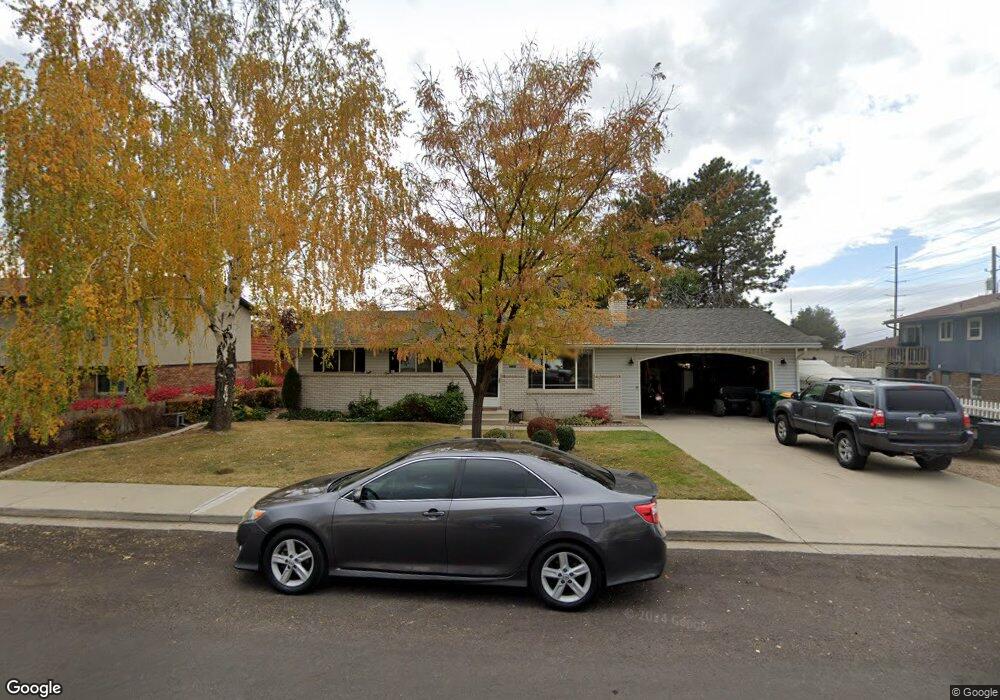
1581 N 1040 W Orem, UT 84057
Aspen NeighborhoodEstimated Value: $488,000 - $522,837
5
Beds
2
Baths
2,160
Sq Ft
$233/Sq Ft
Est. Value
About This Home
This home is located at 1581 N 1040 W, Orem, UT 84057 and is currently estimated at $503,959, approximately $233 per square foot. 1581 N 1040 W is a home located in Utah County with nearby schools including Bonneville Elementary School, Orem Junior High School, and Timpanogos High School.
Ownership History
Date
Name
Owned For
Owner Type
Purchase Details
Closed on
Oct 19, 2021
Sold by
Johnston Denton T
Bought by
Johnston Denton
Current Estimated Value
Home Financials for this Owner
Home Financials are based on the most recent Mortgage that was taken out on this home.
Original Mortgage
$315,000
Outstanding Balance
$287,251
Interest Rate
2.8%
Mortgage Type
New Conventional
Estimated Equity
$216,708
Purchase Details
Closed on
Nov 2, 2016
Sold by
Johnston Denton
Bought by
Johnston Denton T
Home Financials for this Owner
Home Financials are based on the most recent Mortgage that was taken out on this home.
Original Mortgage
$177,000
Interest Rate
3.48%
Mortgage Type
New Conventional
Purchase Details
Closed on
Mar 29, 2005
Sold by
Rohner Justin and 1581 Needles Trust
Bought by
Johnston Denton
Home Financials for this Owner
Home Financials are based on the most recent Mortgage that was taken out on this home.
Original Mortgage
$128,800
Interest Rate
5.6%
Mortgage Type
Purchase Money Mortgage
Purchase Details
Closed on
Mar 11, 2005
Sold by
Needles Jason Michael and Needles Heidi O
Bought by
Rohner Justin and 1581 Needles Trust
Home Financials for this Owner
Home Financials are based on the most recent Mortgage that was taken out on this home.
Original Mortgage
$128,800
Interest Rate
5.6%
Mortgage Type
Purchase Money Mortgage
Purchase Details
Closed on
Jul 1, 2003
Sold by
Devries Matthew J and Devries Pia M
Bought by
Cendant Mobility Financial Corp
Purchase Details
Closed on
Jun 27, 2003
Sold by
Cendant Mobility Government Financial Se
Bought by
Needles Jason and Needles Heidi O
Purchase Details
Closed on
Mar 29, 1999
Sold by
Talbot Mark H and Talbot Stephanie
Bought by
Devries Matthew J and Devries Pia M
Home Financials for this Owner
Home Financials are based on the most recent Mortgage that was taken out on this home.
Original Mortgage
$133,950
Interest Rate
6.79%
Purchase Details
Closed on
Jul 29, 1998
Sold by
Talbot Mark H and Talbot Stephanie J
Bought by
Talbot Mark and Talbot Stephanie
Home Financials for this Owner
Home Financials are based on the most recent Mortgage that was taken out on this home.
Original Mortgage
$115,550
Interest Rate
6.9%
Create a Home Valuation Report for This Property
The Home Valuation Report is an in-depth analysis detailing your home's value as well as a comparison with similar homes in the area
Home Values in the Area
Average Home Value in this Area
Purchase History
| Date | Buyer | Sale Price | Title Company |
|---|---|---|---|
| Johnston Denton | -- | Highland Title | |
| Johnston Denton T | -- | Greenbrier Title Ins Agency | |
| Johnston Denton | -- | Utah First Title Insurance | |
| Rohner Justin | -- | -- | |
| Cendant Mobility Financial Corp | -- | First American Title Co | |
| Needles Jason | -- | First American Title Co | |
| Devries Matthew J | -- | Signature Title | |
| Talbot Mark | -- | First American Title |
Source: Public Records
Mortgage History
| Date | Status | Borrower | Loan Amount |
|---|---|---|---|
| Open | Johnston Denton | $315,000 | |
| Closed | Johnston Denton T | $177,000 | |
| Closed | Johnston Denton | $128,800 | |
| Previous Owner | Devries Matthew J | $133,950 | |
| Previous Owner | Talbot Mark | $115,550 |
Source: Public Records
Tax History
| Year | Tax Paid | Tax Assessment Tax Assessment Total Assessment is a certain percentage of the fair market value that is determined by local assessors to be the total taxable value of land and additions on the property. | Land | Improvement |
|---|---|---|---|---|
| 2025 | $1,862 | $241,450 | -- | -- |
| 2024 | $1,862 | $227,700 | $0 | $0 |
| 2023 | $1,716 | $225,555 | $0 | $0 |
| 2022 | $1,712 | $218,020 | $0 | $0 |
| 2021 | $1,593 | $307,300 | $150,600 | $156,700 |
| 2020 | $1,446 | $274,100 | $120,500 | $153,600 |
| 2019 | $1,358 | $267,600 | $120,500 | $147,100 |
| 2018 | $1,319 | $248,400 | $110,200 | $138,200 |
| 2017 | $1,258 | $126,885 | $0 | $0 |
| 2016 | $1,271 | $118,195 | $0 | $0 |
| 2015 | $1,199 | $105,490 | $0 | $0 |
| 2014 | $1,157 | $101,310 | $0 | $0 |
Source: Public Records
Map
Nearby Homes
- 967 W 1630 N
- 1565 N 1150 W
- 1732 N 1030 W
- 1028 W 1375 N
- 1260 W 1480 N
- 1514 N 1285 W Unit 58
- 1253 W 1420 N
- 1326 W 1480 N
- 1405 N 770 W
- 1552 N 740 W
- 1917 N 860 W
- 1175 N 950 W
- 999 W 1100 N
- 1545 N State St Unit 1
- 983 W 1055 N Unit 812
- 582 W 1300 N
- 527 W 1450 N
- 1015 N 995 W
- 512 W 1450 N
- 1004 N 1090 W Unit 203
Your Personal Tour Guide
Ask me questions while you tour the home.