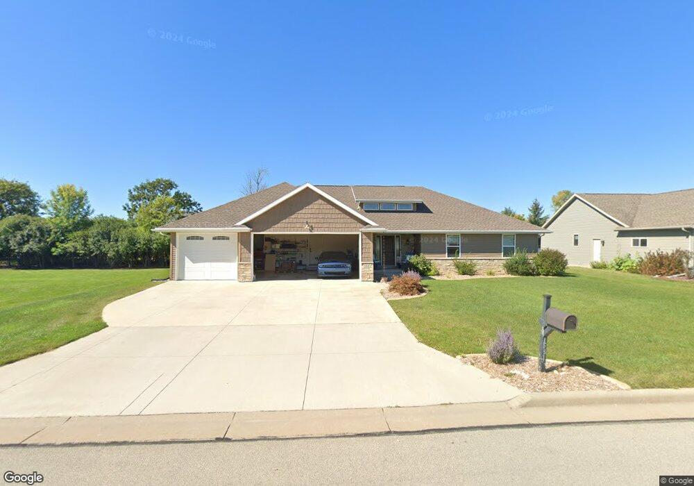
1581 Remington Rd Neenah, WI 54956
Estimated Value: $130,000 - $168,624
1
Bed
1
Bath
1,663
Sq Ft
$93/Sq Ft
Est. Value
About This Home
This home is located at 1581 Remington Rd, Neenah, WI 54956 and is currently estimated at $154,406, approximately $92 per square foot. 1581 Remington Rd is a home with nearby schools including Lakeview Elementary School, Horace Mann Middle School, and Neenah Middle School.
Ownership History
Date
Name
Owned For
Owner Type
Purchase Details
Closed on
Aug 26, 2019
Sold by
Castle Sullivan Llc
Bought by
Krysiak Kyle T
Current Estimated Value
Home Financials for this Owner
Home Financials are based on the most recent Mortgage that was taken out on this home.
Original Mortgage
$58,300
Outstanding Balance
$51,274
Interest Rate
3.8%
Mortgage Type
New Conventional
Estimated Equity
$103,132
Purchase Details
Closed on
Feb 3, 2014
Sold by
Sullivan Jason and Sullivan Rebecca
Bought by
Castle Sullivan Llc
Create a Home Valuation Report for This Property
The Home Valuation Report is an in-depth analysis detailing your home's value as well as a comparison with similar homes in the area
Home Values in the Area
Average Home Value in this Area
Purchase History
| Date | Buyer | Sale Price | Title Company |
|---|---|---|---|
| Krysiak Kyle T | $61,400 | None Available | |
| Castle Sullivan Llc | -- | None Available |
Source: Public Records
Mortgage History
| Date | Status | Borrower | Loan Amount |
|---|---|---|---|
| Open | Krysiak Kyle T | $58,300 |
Source: Public Records
Tax History Compared to Growth
Tax History
| Year | Tax Paid | Tax Assessment Tax Assessment Total Assessment is a certain percentage of the fair market value that is determined by local assessors to be the total taxable value of land and additions on the property. | Land | Improvement |
|---|---|---|---|---|
| 2024 | $5,045 | $131,200 | $25,000 | $106,200 |
| 2023 | $3,781 | $76,500 | $15,700 | $60,800 |
| 2022 | $1,706 | $329,300 | $47,500 | $281,800 |
| 2021 | $1,483 | $325,300 | $47,500 | $277,800 |
| 2020 | $6,795 | $325,300 | $47,500 | $277,800 |
| 2019 | $1,277 | $325,300 | $47,500 | $277,800 |
| 2018 | $1,215 | $268,000 | $45,600 | $222,400 |
| 2017 | $1,228 | $267,300 | $45,600 | $221,700 |
| 2016 | $1,453 | $22,400 | $22,400 | $0 |
| 2015 | $1,458 | $58,000 | $15,700 | $42,300 |
| 2014 | $1,461 | $58,000 | $15,700 | $42,300 |
| 2013 | $1,462 | $58,000 | $15,700 | $42,300 |
Source: Public Records
Map
Nearby Homes
- 1545 Whitetail Dr
- 1509 Meadowbreeze Cir
- 1535 Freedom Meadows Dr
- 1539 Freedom Meadows Dr
- 1442 Baytree Ln
- 1341 Alpine Ln
- 1372 Baytree Ln
- 1715 Sovereign Way
- 1738 Sovereign Way
- 1721 Freeman Dr
- 1711 Sovereign Way
- 1468 Plains Ave
- 1777 Loyal Dr
- 1641-HA-51 Plan at Freedom Meadows
- 1654-CH-55.5 Plan at Freedom Meadows
- 1664-PA-44.5 Plan at Freedom Meadows
- 1662-AS-56.5 Plan at Freedom Meadows
- 1485-JU-36 Plan at Freedom Meadows
- 1598-CH-55 Plan at Freedom Meadows
- 1620-PA-44.5 Plan at Freedom Meadows
- 1577 Remington Rd
- 1585 Remington Rd
- 1578 Lone Oak Dr
- 1578 Lone Oak Dr
- 1582 Lone Oak Dr
- 1574 Lone Oak Dr
- 1573 Remington Rd
- 1579 1579 Lone Oak Dr
- 1586 Lone Oak Dr
- 1584 Remington Rd
- 1589 Remington Rd
- 1583 1583 Lone Oak Dr
- 1569 Remington Rd
- 1570 Remington Rd
- 1587 1587 Lone Oak Dr
- 1590 Lone Oak Dr
- 1579 Lone Oak Dr
- 1588 Remington Rd
- 1583 Lone Oak Dr
- 1587 Kingswood Dr