Estimated Value: $374,000 - $428,000
4
Beds
2
Baths
2,310
Sq Ft
$171/Sq Ft
Est. Value
About This Home
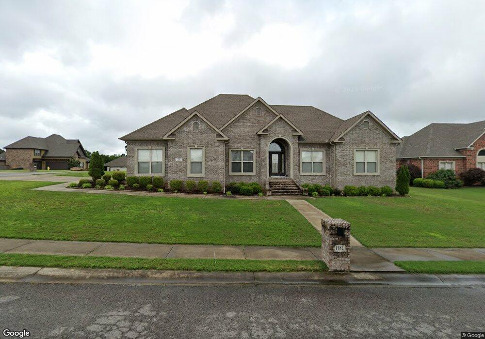
This home is located at 1582 Mcafee Cir, Cabot, AR 72023 and is currently estimated at $394,577, approximately $170 per square foot. 1582 Mcafee Cir is a home located in Lonoke County with nearby schools including Mountain Springs Elementary School, Cabot Middle School North, and Cabot Junior High North.
Ownership History
Date
Name
Owned For
Owner Type
Purchase Details
Closed on
Apr 24, 2014
Bought by
Heritage Homes And Development Inc
Current Estimated Value
Home Financials for this Owner
Home Financials are based on the most recent Mortgage that was taken out on this home.
Original Mortgage
$193,500
Outstanding Balance
$146,473
Interest Rate
4.46%
Mortgage Type
Construction
Estimated Equity
$248,104
Purchase Details
Closed on
Jun 21, 2006
Bought by
Pc2-853
Create a Home Valuation Report for This Property
The Home Valuation Report is an in-depth analysis detailing your home's value as well as a comparison with similar homes in the area
Purchase History
| Date | Buyer | Sale Price | Title Company |
|---|---|---|---|
| Heritage Homes And Development Inc | -- | -- | |
| Pc2-853 | -- | -- |
Source: Public Records
Mortgage History
| Date | Status | Borrower | Loan Amount |
|---|---|---|---|
| Open | Heritage Homes And Development Inc | $193,500 |
Source: Public Records
Tax History
| Year | Tax Paid | Tax Assessment Tax Assessment Total Assessment is a certain percentage of the fair market value that is determined by local assessors to be the total taxable value of land and additions on the property. | Land | Improvement |
|---|---|---|---|---|
| 2025 | $1,672 | $47,580 | $5,000 | $42,580 |
| 2024 | $1,672 | $47,580 | $5,000 | $42,580 |
| 2023 | $1,672 | $47,580 | $5,000 | $42,580 |
| 2022 | $1,722 | $47,580 | $5,000 | $42,580 |
| 2021 | $1,722 | $47,580 | $5,000 | $42,580 |
| 2020 | $1,722 | $42,380 | $3,800 | $38,580 |
| 2019 | $1,722 | $42,380 | $3,800 | $38,580 |
| 2018 | $1,685 | $42,380 | $3,800 | $38,580 |
| 2017 | $1,891 | $42,380 | $3,800 | $38,580 |
| 2016 | $1,685 | $42,380 | $3,800 | $38,580 |
| 2015 | $1,685 | $0 | $0 | $0 |
| 2014 | $94 | $1,900 | $1,900 | $0 |
Source: Public Records
Map
Nearby Homes
- 1570 Marquee Cir
- 1533 Signature
- 1593 Vista Dr
- 1481 Greystone Blvd
- 1505 Cypress Point St
- 104 Lethamhill Cove
- 971 Augusta St
- 15 Sawgrass St
- 972 Augusta St
- 974 Augusta St
- 950 Pinehurst Loop
- 813 Cascade Dr
- 77 Cypress Creek Dr
- 83 Cypress Creek Dr
- 601 Greystone Blvd
- 34 Cypress Creek Dr
- 32 Cypress Creek Dr
- 507 Greystone Blvd
- 708 Greystone Blvd
- 904 Greystone Blvd
- 1580 Mcafee Cir
- 1550 Mcafee Cir
- 1546 Cypress Point St
- 1552 Mcafee Cir
- 1548 Cypress Point St
- 1583 Mcafee Cir
- 1578 Mcafee Cir
- 1581 Mcafee Cir
- 1544 Cypress Point St
- 1550 Cypress Point St
- 1554 Mcafee Cir
- 1579 Mcafee Cir
- 1576 Mcafee Cir
- 0 Mcafee Unit 16033632
- 0 Mcafee Unit 20030410
- 0 Mcafee Unit 17014238
- 0 Mcafee Unit 17014207
- 0 Lot 40 McAfee Cir Unit 10360067
- 0 Lot 39 McAfee Cir Unit 10360066
- 0 Lot 36 McAfee Cir Unit 10360065
Your Personal Tour Guide
Ask me questions while you tour the home.