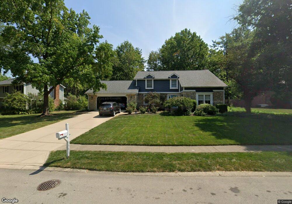
1583 White Ash Dr Carmel, IN 46033
East Carmel NeighborhoodEstimated Value: $505,000 - $557,879
4
Beds
3
Baths
3,515
Sq Ft
$151/Sq Ft
Est. Value
About This Home
This home is located at 1583 White Ash Dr, Carmel, IN 46033 and is currently estimated at $530,970, approximately $151 per square foot. 1583 White Ash Dr is a home located in Hamilton County with nearby schools including Cherry Tree Elementary School, Clay Middle School, and Carmel High School.
Ownership History
Date
Name
Owned For
Owner Type
Purchase Details
Closed on
Dec 2, 2024
Sold by
Sullivan Jay G
Bought by
Sullivan Lori C
Current Estimated Value
Purchase Details
Closed on
Oct 3, 2002
Sold by
Little Pamela L
Bought by
Sullivan Jay G and Sullivan Lori C
Home Financials for this Owner
Home Financials are based on the most recent Mortgage that was taken out on this home.
Original Mortgage
$195,500
Interest Rate
6.39%
Mortgage Type
Purchase Money Mortgage
Create a Home Valuation Report for This Property
The Home Valuation Report is an in-depth analysis detailing your home's value as well as a comparison with similar homes in the area
Home Values in the Area
Average Home Value in this Area
Purchase History
| Date | Buyer | Sale Price | Title Company |
|---|---|---|---|
| Sullivan Lori C | -- | None Listed On Document | |
| Sullivan Jay G | -- | Chicago Title Carmel |
Source: Public Records
Mortgage History
| Date | Status | Borrower | Loan Amount |
|---|---|---|---|
| Previous Owner | Sullivan Jay G | $195,500 |
Source: Public Records
Tax History Compared to Growth
Tax History
| Year | Tax Paid | Tax Assessment Tax Assessment Total Assessment is a certain percentage of the fair market value that is determined by local assessors to be the total taxable value of land and additions on the property. | Land | Improvement |
|---|---|---|---|---|
| 2024 | $5,458 | $480,100 | $120,400 | $359,700 |
| 2023 | $5,458 | $499,200 | $111,900 | $387,300 |
| 2022 | $4,360 | $383,900 | $111,900 | $272,000 |
| 2021 | $3,647 | $324,500 | $111,900 | $212,600 |
| 2020 | $3,208 | $286,600 | $111,900 | $174,700 |
| 2019 | $3,209 | $289,900 | $60,800 | $229,100 |
| 2018 | $3,019 | $277,800 | $60,800 | $217,000 |
| 2017 | $2,981 | $275,600 | $60,800 | $214,800 |
| 2016 | $2,831 | $262,200 | $60,800 | $201,400 |
| 2014 | $2,511 | $247,000 | $48,100 | $198,900 |
| 2013 | $2,511 | $240,600 | $48,100 | $192,500 |
Source: Public Records
Map
Nearby Homes
- 781 Dayton Dr
- 1816 Spruce Dr
- 651 Hawthorne Dr
- 4655 Allen Dr
- 1483 Spruce Dr
- 1346 Smokey Row Ln
- 1910 Spruce Dr
- 1504 Dorchester Place
- 1983 Woodbine Ct
- 13233 Hazelwood Dr
- 128 1st Ct
- 4443 E Main St
- 13082 Andover Dr
- 14340 Sydney Ln
- 13615 Smokey Hollow Place
- 3172 Smokey Ridge Ln
- 14011 Grisham Dr
- 14554 Taylor Trace Dr
- 2913 Twain Dr
- 4950 Tudor Place
- 1607 White Ash Dr
- 1575 White Ash Dr
- 1654 Obara Ct
- 1625 White Ash Dr
- 1594 White Ash Dr
- 1586 White Ash Dr
- 1580 White Ash Dr
- 1559 White Ash Dr
- 1612 White Ash Dr
- 1568 White Ash Dr
- 1641 White Ash Dr
- 1666 Obara Ct
- 1642 Obara Ct
- 1642 O'Bara Ct
- 1545 White Ash Dr
- 1620 White Ash Dr
- 1556 White Ash Dr
- 757 Ironwood Dr
- 823 Ironwood Dr
- 749 Ironwood Dr