Estimated Value: $948,000 - $1,435,000
5
Beds
5
Baths
4,605
Sq Ft
$249/Sq Ft
Est. Value
About This Home
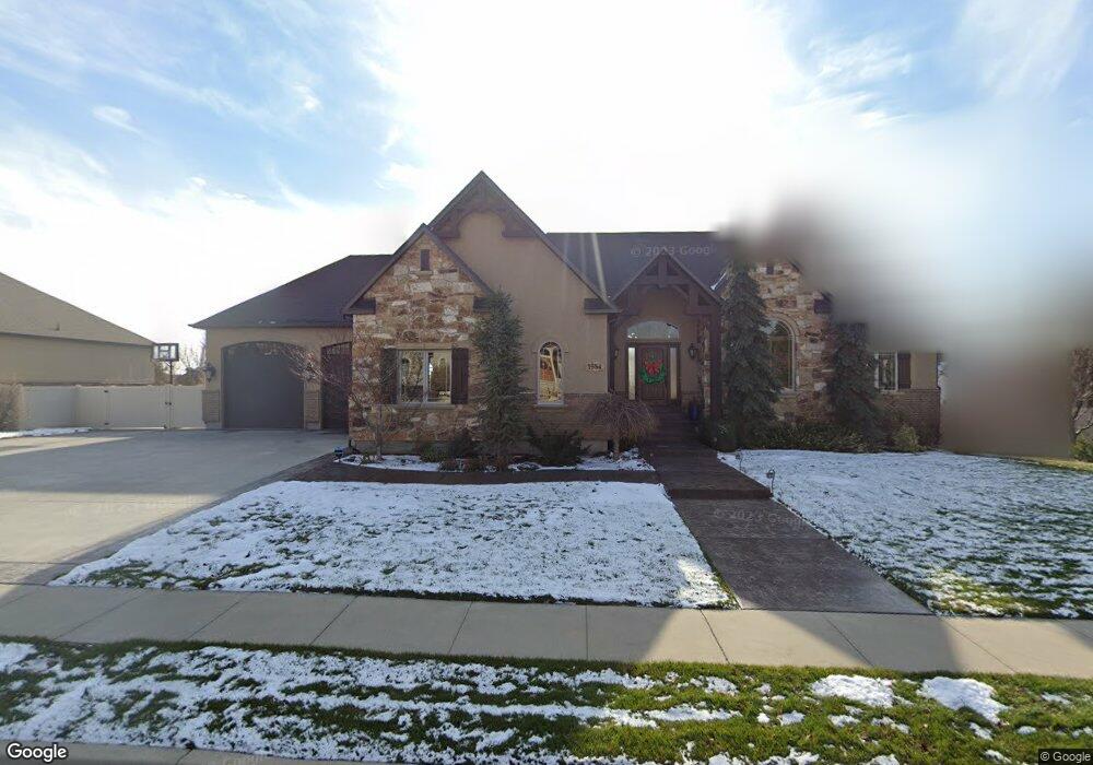
This home is located at 1584 E 1130 N, Lehi, UT 84043 and is currently estimated at $1,148,850, approximately $249 per square foot. 1584 E 1130 N is a home located in Utah County with nearby schools including Freedom Elementary School, Lehi Junior High School, and Skyridge High School.
Ownership History
Date
Name
Owned For
Owner Type
Purchase Details
Closed on
Sep 16, 2024
Sold by
Clark Vincent
Bought by
Clark Vincent and Clark Micaela
Current Estimated Value
Home Financials for this Owner
Home Financials are based on the most recent Mortgage that was taken out on this home.
Original Mortgage
$249,900
Outstanding Balance
$243,578
Interest Rate
6.47%
Mortgage Type
Credit Line Revolving
Estimated Equity
$905,272
Purchase Details
Closed on
Sep 1, 2024
Sold by
Clark Vincent and Clark Micaela
Bought by
Clark Vincent
Home Financials for this Owner
Home Financials are based on the most recent Mortgage that was taken out on this home.
Original Mortgage
$249,900
Outstanding Balance
$243,578
Interest Rate
6.47%
Mortgage Type
Credit Line Revolving
Estimated Equity
$905,272
Purchase Details
Closed on
Oct 14, 2019
Sold by
Clark Michael A and Clark Sarah A
Bought by
Clark Michael A and Clark Sarah A
Home Financials for this Owner
Home Financials are based on the most recent Mortgage that was taken out on this home.
Original Mortgage
$407,900
Interest Rate
3.4%
Mortgage Type
New Conventional
Purchase Details
Closed on
Sep 27, 2017
Sold by
Holyoak William P and Holyoak Alice C
Bought by
Clark Vincent and Clark Micaela
Home Financials for this Owner
Home Financials are based on the most recent Mortgage that was taken out on this home.
Original Mortgage
$424,100
Interest Rate
3.89%
Mortgage Type
New Conventional
Purchase Details
Closed on
Jul 26, 2010
Sold by
Central Bank
Bought by
Holyoak William P and Holyoak Alice C
Home Financials for this Owner
Home Financials are based on the most recent Mortgage that was taken out on this home.
Original Mortgage
$380,000
Interest Rate
4.68%
Mortgage Type
New Conventional
Purchase Details
Closed on
Mar 10, 2010
Sold by
Hardman Clint W
Bought by
Central Bank
Purchase Details
Closed on
Apr 3, 2007
Sold by
Curly Investments Llc
Bought by
Hardman Clint W
Create a Home Valuation Report for This Property
The Home Valuation Report is an in-depth analysis detailing your home's value as well as a comparison with similar homes in the area
Home Values in the Area
Average Home Value in this Area
Purchase History
| Date | Buyer | Sale Price | Title Company |
|---|---|---|---|
| Clark Vincent | -- | First American Title Insurance | |
| Clark Vincent | -- | First American Title Insurance | |
| Clark Michael A | -- | None Available | |
| Clark Vincent | -- | Eagle Pointe Title Ins Agenc | |
| Holyoak William P | -- | Fidelity Land & Title | |
| Central Bank | $550,000 | None Available | |
| Hardman Clint W | -- | Pro Title & Escrow Inc |
Source: Public Records
Mortgage History
| Date | Status | Borrower | Loan Amount |
|---|---|---|---|
| Open | Clark Vincent | $249,900 | |
| Previous Owner | Clark Michael A | $407,900 | |
| Previous Owner | Clark Vincent | $424,100 | |
| Previous Owner | Holyoak William P | $380,000 |
Source: Public Records
Tax History Compared to Growth
Tax History
| Year | Tax Paid | Tax Assessment Tax Assessment Total Assessment is a certain percentage of the fair market value that is determined by local assessors to be the total taxable value of land and additions on the property. | Land | Improvement |
|---|---|---|---|---|
| 2025 | $4,493 | $603,020 | $394,200 | $702,200 |
| 2024 | $4,493 | $525,855 | $0 | $0 |
| 2023 | $4,022 | $511,060 | $0 | $0 |
| 2022 | $4,663 | $574,420 | $0 | $0 |
| 2021 | $4,198 | $781,800 | $228,100 | $553,700 |
| 2020 | $3,959 | $728,700 | $211,200 | $517,500 |
| 2019 | $3,745 | $716,600 | $211,200 | $505,400 |
| 2018 | $3,533 | $639,200 | $199,700 | $439,500 |
| 2017 | $3,047 | $293,040 | $0 | $0 |
| 2016 | $3,162 | $282,150 | $0 | $0 |
| 2015 | $3,331 | $282,150 | $0 | $0 |
| 2014 | $2,921 | $246,015 | $0 | $0 |
Source: Public Records
Map
Nearby Homes
- 893 N 1580 E
- 9435 N Aspen Hollow Cir
- 3935 W 1000 N Unit 438
- 3983 W 1000 N Unit 442
- 4007 W 1000 N
- 3947 W 1000 N Unit 439
- 3959 W 1000 N
- 1175 E 900 N
- 901 N Lakota Rd
- 595 N 1200 E
- 822 N 860 W Unit 317
- 418 N 1322 E
- 735 N 1000 E
- 822 W 800 St N Unit LOT319
- 6692 W 9770 N
- 458 N 1100 E Unit 3
- 832 N Somerset Alley
- 328 N 1270 E
- 602 W 860 N
- 962 N 780 St W Unit 508
- 1122 N 1540 E
- 1583 E 1060 N Unit 21
- 1562 E 1130 N Unit 19
- 1612 E 1130 N Unit 17
- 1612 E 1130 N
- 1609 E 1060 N
- 1589 E 1130 N
- 1561 E 1060 N
- 1635 E 1060 N
- 1126 N 1610 E
- 1148 N 1610 E
- 1052 N 1540 E Unit 35
- 1111 N 1540 E
- 1588 E 1060 N Unit 34
- 1588 E 1060 N
- 1135 N 1540 E
- 1081 N 1540 E Unit 9
- 1081 N 1540 E
- 1614 E 1060 N
- 1614 E 1060 N Unit 33