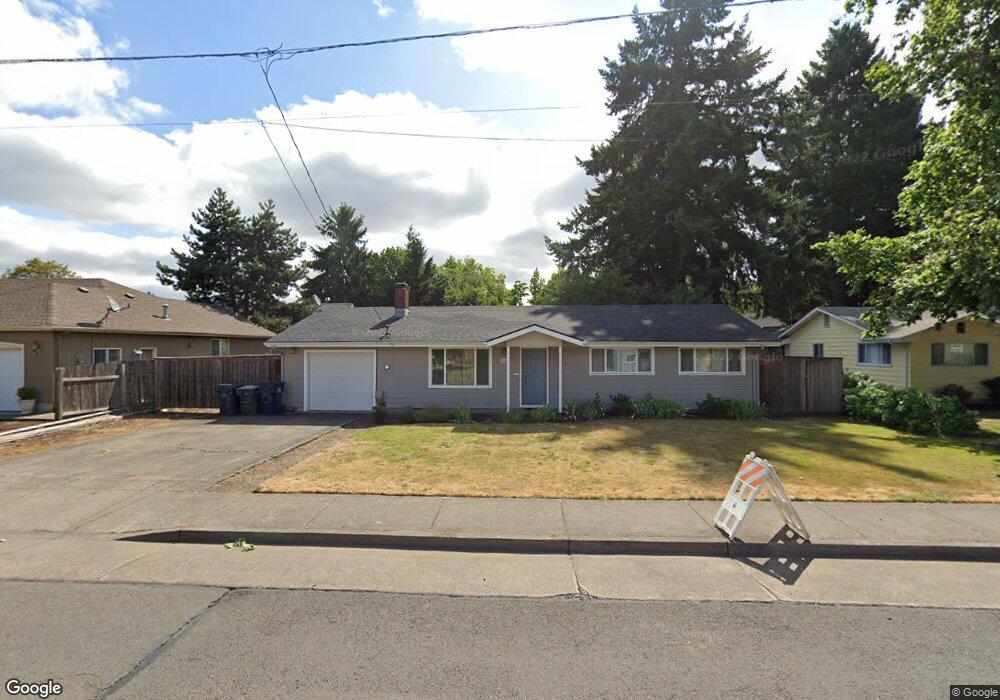
1585 Bogart Ln Eugene, OR 97401
Harlow NeighborhoodEstimated Value: $424,823 - $477,000
3
Beds
2
Baths
1,271
Sq Ft
$352/Sq Ft
Est. Value
About This Home
This home is located at 1585 Bogart Ln, Eugene, OR 97401 and is currently estimated at $447,206, approximately $351 per square foot. 1585 Bogart Ln is a home located in Lane County with nearby schools including Holt Elementary School, Monroe Middle School, and Sheldon High School.
Ownership History
Date
Name
Owned For
Owner Type
Purchase Details
Closed on
Sep 25, 2025
Sold by
Sebring Mark N and Sebring Linda J
Bought by
Sebring Trust and Sebring
Current Estimated Value
Purchase Details
Closed on
Aug 8, 2002
Sold by
Portis William L and Portis Shirley F
Bought by
Sebring Mark N and Sebring Linda J
Home Financials for this Owner
Home Financials are based on the most recent Mortgage that was taken out on this home.
Original Mortgage
$119,700
Interest Rate
6.52%
Create a Home Valuation Report for This Property
The Home Valuation Report is an in-depth analysis detailing your home's value as well as a comparison with similar homes in the area
Home Values in the Area
Average Home Value in this Area
Purchase History
| Date | Buyer | Sale Price | Title Company |
|---|---|---|---|
| Sebring Trust | -- | None Listed On Document | |
| Sebring Mark N | $135,000 | Western Pioneer Title Co |
Source: Public Records
Mortgage History
| Date | Status | Borrower | Loan Amount |
|---|---|---|---|
| Previous Owner | Sebring Mark N | $119,700 |
Source: Public Records
Tax History
| Year | Tax Paid | Tax Assessment Tax Assessment Total Assessment is a certain percentage of the fair market value that is determined by local assessors to be the total taxable value of land and additions on the property. | Land | Improvement |
|---|---|---|---|---|
| 2025 | $3,875 | $198,885 | -- | -- |
| 2024 | $3,827 | $193,093 | -- | -- |
| 2023 | $3,827 | $187,469 | $0 | $0 |
| 2022 | $3,585 | $182,009 | $0 | $0 |
| 2021 | $3,367 | $176,708 | $0 | $0 |
| 2020 | $3,379 | $171,562 | $0 | $0 |
| 2019 | $3,264 | $166,566 | $0 | $0 |
| 2018 | $3,072 | $157,005 | $0 | $0 |
| 2017 | $2,934 | $157,005 | $0 | $0 |
| 2016 | $2,862 | $152,432 | $0 | $0 |
| 2015 | $2,779 | $147,992 | $0 | $0 |
| 2014 | $2,723 | $143,682 | $0 | $0 |
Source: Public Records
Map
Nearby Homes
- 0 Sprig Ln Unit Lot 3
- 0 Sprig Ln Unit Lot 3 766109892
- 1564 Regency Dr
- 1630 Ridgley Blvd
- 2956 Willakenzie Rd
- 3424 Sussex St
- 1271 Arcadia Dr
- 825 Waverly St
- 2580 Elysium Ave
- 2577 Elysium Ave
- 1090 Corydon St
- 950 Coburg Rd
- 2495 Jeppesen Acres Rd
- 2872 Suffolk Ct
- 2746 Harlow Rd
- 2420 Willona Dr
- 2345 Pioneer Pike
- 349 van Duyn St
- 600 Cherry Dr Unit 8
- 600 Cherry Dr Unit 3
- 1565 Bogart Ln
- 1595 Bogart Ln
- 1582 Bogart Ln
- 1580 Bogart Ln
- 3130 Willakenzie Rd
- 1545 Bogart Ln
- 1590 Bogart Ln
- 1553 Bogart Ln
- 1558 Bogart Ln
- 3206 Willakenzie Rd
- 3204 Willakenzie Rd
- 3208 Willakenzie Rd
- 3210 Willakenzie Rd
- 3212 Willakenzie Rd
- 3214 Willakenzie Rd
- 1523 Bogart Ln
- 3216 Willakenzie Rd
- 1524 Bogart Ln
- 3218 Willakenzie Rd
- 3127 Willakenzie Rd
Your Personal Tour Guide
Ask me questions while you tour the home.