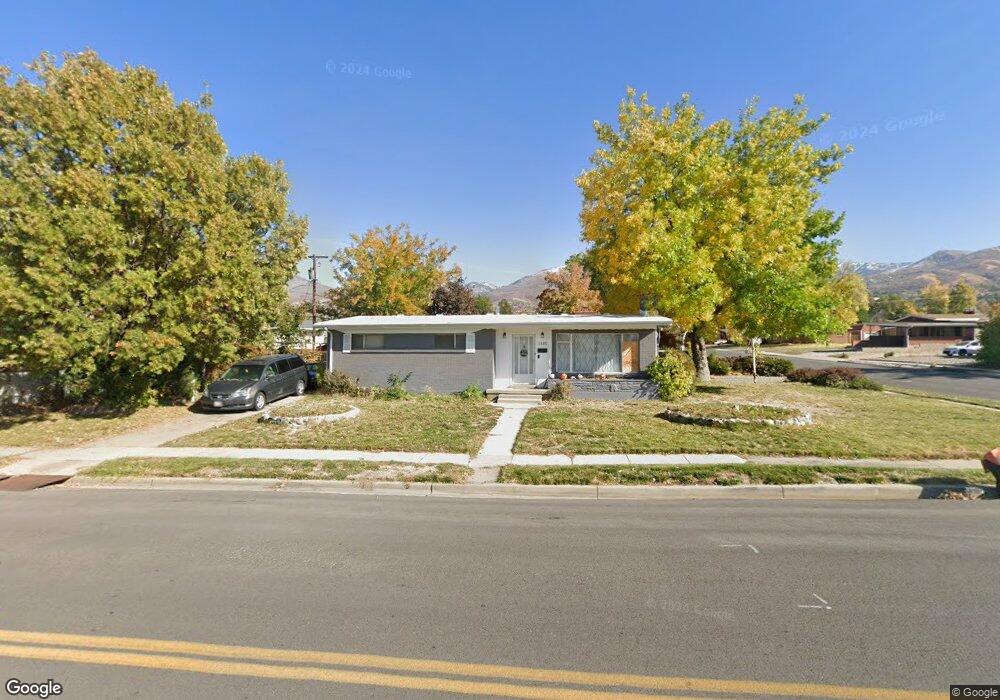
1585 S 50 W Bountiful, UT 84010
Estimated Value: $460,000 - $476,000
2
Beds
2
Baths
1,102
Sq Ft
$427/Sq Ft
Est. Value
About This Home
This home is located at 1585 S 50 W, Bountiful, UT 84010 and is currently estimated at $470,397, approximately $426 per square foot. 1585 S 50 W is a home located in Davis County with nearby schools including Bountiful Elementary School, Mueller Park Junior High School, and Bountiful High School.
Ownership History
Date
Name
Owned For
Owner Type
Purchase Details
Closed on
Nov 10, 2008
Sold by
Stapley Craig Paul
Bought by
Shegrud Renee S
Current Estimated Value
Purchase Details
Closed on
Apr 21, 2005
Sold by
Alley Stephen W and Alley Marcie C
Bought by
Alley Stephen W
Create a Home Valuation Report for This Property
The Home Valuation Report is an in-depth analysis detailing your home's value as well as a comparison with similar homes in the area
Home Values in the Area
Average Home Value in this Area
Purchase History
| Date | Buyer | Sale Price | Title Company |
|---|---|---|---|
| Shegrud Renee S | -- | None Available | |
| Alley Stephen W | -- | Equity Title Ins Agency Inc |
Source: Public Records
Tax History Compared to Growth
Tax History
| Year | Tax Paid | Tax Assessment Tax Assessment Total Assessment is a certain percentage of the fair market value that is determined by local assessors to be the total taxable value of land and additions on the property. | Land | Improvement |
|---|---|---|---|---|
| 2025 | $2,606 | $232,650 | $127,547 | $105,103 |
| 2024 | $2,391 | $223,849 | $112,587 | $111,262 |
| 2023 | $2,302 | $215,050 | $114,650 | $100,399 |
| 2022 | $2,442 | $415,000 | $207,608 | $207,392 |
| 2021 | $2,010 | $285,000 | $151,027 | $133,973 |
| 2020 | $1,743 | $247,000 | $129,258 | $117,742 |
| 2019 | $1,742 | $241,000 | $138,203 | $102,797 |
| 2018 | $1,626 | $221,000 | $135,511 | $85,489 |
| 2016 | $1,477 | $109,175 | $55,716 | $53,459 |
| 2015 | $1,489 | $101,365 | $55,716 | $45,649 |
| 2014 | $1,466 | $105,584 | $55,716 | $49,868 |
| 2013 | -- | $98,182 | $43,945 | $54,237 |
Source: Public Records
Map
Nearby Homes
- 99 E 1600 S
- 90 W 1300 S
- 141 E 1650 S
- 1350 S 200 W
- 1314 S 200 W Unit 19
- 285 E 1650 S
- 33 W Wicker Ln
- 1950 S 200 W Unit 32
- 1820 S 440 W
- 1871 S 350 E
- 2095 S Main St Unit 17
- 2095 S Main St Unit 23
- 296 E 2050 S Unit 2
- 2038 S 350 E Unit 3
- 2059 S 350 E Unit 6
- 295 E 2050 S Unit 1
- Edgewood A Plan at Oakhaven Park
- Oakhaven Plan at Oakhaven Park
- Fairmont Plan at Oakhaven Park
- Brierwood Plan at Oakhaven Park