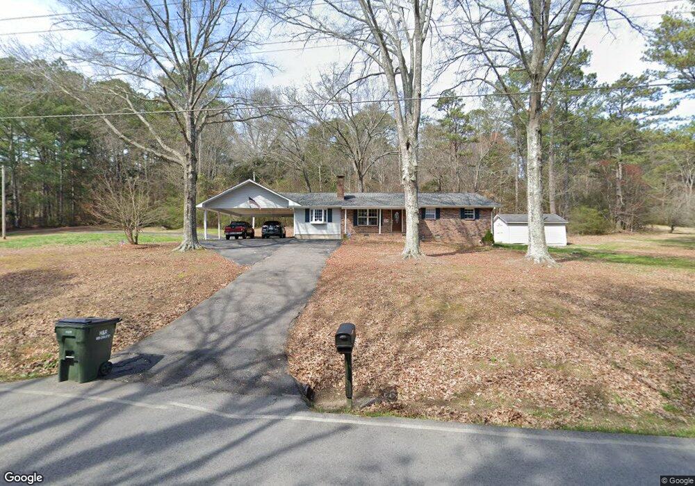
1586 Peavine Rd Rock Spring, GA 30739
Rock Spring NeighborhoodEstimated Value: $307,035 - $337,000
3
Beds
2
Baths
1,881
Sq Ft
$171/Sq Ft
Est. Value
About This Home
This home is located at 1586 Peavine Rd, Rock Spring, GA 30739 and is currently estimated at $322,259, approximately $171 per square foot. 1586 Peavine Rd is a home located in Walker County with nearby schools including Rock Spring Elementary School and Lafayette High School.
Ownership History
Date
Name
Owned For
Owner Type
Purchase Details
Closed on
Mar 1, 2021
Sold by
Watts Kenneth R
Bought by
Tiraco Jack Edward and Watts Carla E
Current Estimated Value
Purchase Details
Closed on
Sep 2, 1987
Sold by
Sink James V and Sink Faye
Bought by
Watts Kenneth R and Watts Carla E
Purchase Details
Closed on
Jun 16, 1980
Sold by
Cooper Harvey L and Cooper Gloria J
Bought by
Sink James V and Sink Faye
Purchase Details
Closed on
Jul 3, 1975
Sold by
Lewis Frank S
Bought by
Cooper Harvey L and Cooper Gloria J
Purchase Details
Closed on
Jan 1, 1965
Bought by
Lewis Frank S
Create a Home Valuation Report for This Property
The Home Valuation Report is an in-depth analysis detailing your home's value as well as a comparison with similar homes in the area
Home Values in the Area
Average Home Value in this Area
Purchase History
| Date | Buyer | Sale Price | Title Company |
|---|---|---|---|
| Tiraco Jack Edward | $215,000 | -- | |
| Watts Kenneth R | $55,000 | -- | |
| Sink James V | $43,100 | -- | |
| Cooper Harvey L | -- | -- | |
| Lewis Frank S | -- | -- |
Source: Public Records
Tax History Compared to Growth
Tax History
| Year | Tax Paid | Tax Assessment Tax Assessment Total Assessment is a certain percentage of the fair market value that is determined by local assessors to be the total taxable value of land and additions on the property. | Land | Improvement |
|---|---|---|---|---|
| 2024 | $900 | $102,519 | $7,216 | $95,303 |
| 2023 | $2,084 | $96,256 | $5,727 | $90,529 |
| 2022 | $1,908 | $82,814 | $4,482 | $78,332 |
| 2021 | $1,657 | $59,644 | $4,482 | $55,162 |
| 2020 | $1,424 | $48,782 | $4,482 | $44,300 |
| 2019 | $1,448 | $48,782 | $4,482 | $44,300 |
| 2018 | $1,291 | $48,782 | $4,482 | $44,300 |
| 2017 | $1,583 | $48,782 | $4,482 | $44,300 |
| 2016 | $1,275 | $48,782 | $4,482 | $44,300 |
| 2015 | $1,304 | $47,077 | $8,096 | $38,981 |
| 2014 | $1,202 | $47,077 | $8,096 | $38,981 |
| 2013 | -- | $47,077 | $8,096 | $38,981 |
Source: Public Records
Map
Nearby Homes
- 285 Cooper Rd
- 788 Long Hollow Rd
- 294 E Long Hollow Rd
- 36 Pheonix Cir
- 183 Long Hollow Rd
- 195 Honeysuckle Dr
- 1121 Arnold Rd
- 87 Peavine Rd
- 453 Harvest Ln
- 1476 Arnold Rd
- 1902 Long Hollow Rd
- 100 Deer Ridge Ln
- 103 Deer Ridge Ln
- 186 Henry Dr
- 200 Hunting Ridge Cir
- 54 Cedar Farm Ln
- 140 Fieldstone Commons
- 124 Fieldstone Commons
- 379 N Beaumont Rd
- 1053 Old Three Notch Rd
- 1548 Peavine Rd
- 1508 Peavine Rd
- 1628 Peavine Rd
- 1629 Peavine Rd
- 1472 Peavine Rd
- 1645 Peavine Rd
- 1471 Peavine Rd
- 1663 Peavine Rd
- 1684 Peavine Rd
- 1316 Peavine Rd
- 546 E Long Hollow Rd
- 216 Autumn Crest Trail
- 1736 Peavine Rd
- 1759 Peavine Rd
- 604 E Long Hollow Rd
- 0 Dogwood Cir Unit 935173
- 0 Dogwood Cir Unit 1125867
- 0 Dogwood Cir Unit 8404416
- 592 E Long Hollow Rd
- 570 E Long Hollow Rd