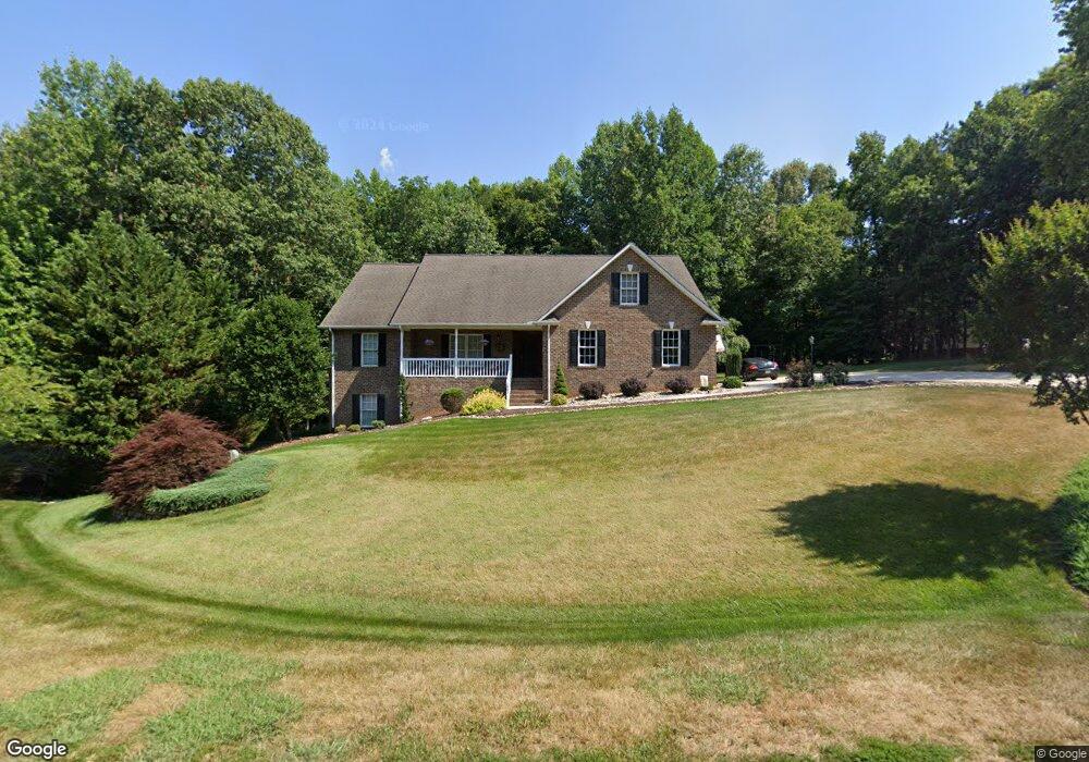
1587 Keyauee Dr Asheboro, NC 27205
Estimated Value: $373,000 - $466,000
--
Bed
2
Baths
1,844
Sq Ft
$226/Sq Ft
Est. Value
About This Home
This home is located at 1587 Keyauee Dr, Asheboro, NC 27205 and is currently estimated at $417,201, approximately $226 per square foot. 1587 Keyauee Dr is a home located in Randolph County with nearby schools including Farmer Elementary School, Uwharrie Ridge Six-Twelve, and Southwestern Randolph High School.
Ownership History
Date
Name
Owned For
Owner Type
Purchase Details
Closed on
Jan 29, 2015
Sold by
Joines Timothy B
Bought by
Davis Charles Brandon and Davis Ryan Michael
Current Estimated Value
Purchase Details
Closed on
Nov 16, 2005
Sold by
Lanier Walter Ray and Lanier Nancy L
Bought by
Davis Charles B and Davis Kimberly C
Home Financials for this Owner
Home Financials are based on the most recent Mortgage that was taken out on this home.
Original Mortgage
$237,500
Interest Rate
6.12%
Mortgage Type
Construction
Create a Home Valuation Report for This Property
The Home Valuation Report is an in-depth analysis detailing your home's value as well as a comparison with similar homes in the area
Home Values in the Area
Average Home Value in this Area
Purchase History
| Date | Buyer | Sale Price | Title Company |
|---|---|---|---|
| Davis Charles Brandon | -- | None Available | |
| Davis Charles B | $22,000 | -- |
Source: Public Records
Mortgage History
| Date | Status | Borrower | Loan Amount |
|---|---|---|---|
| Open | Davis Charles | $220,000 | |
| Closed | Davis Charles | $25,000 | |
| Closed | Davis Charles | $10,000 | |
| Closed | Davis Charles B | $237,500 |
Source: Public Records
Tax History Compared to Growth
Tax History
| Year | Tax Paid | Tax Assessment Tax Assessment Total Assessment is a certain percentage of the fair market value that is determined by local assessors to be the total taxable value of land and additions on the property. | Land | Improvement |
|---|---|---|---|---|
| 2024 | $2,368 | $364,280 | $51,700 | $312,580 |
| 2023 | $2,368 | $364,280 | $51,700 | $312,580 |
| 2022 | $1,787 | $228,260 | $21,020 | $207,240 |
| 2021 | $1,787 | $228,260 | $21,020 | $207,240 |
| 2020 | $1,741 | $228,260 | $21,020 | $207,240 |
| 2019 | $1,741 | $228,260 | $21,020 | $207,240 |
| 2018 | $1,734 | $221,660 | $21,020 | $200,640 |
| 2016 | $1,712 | $221,661 | $21,020 | $200,641 |
| 2015 | $1,696 | $221,661 | $21,020 | $200,641 |
| 2014 | $1,681 | $221,661 | $21,020 | $200,641 |
Source: Public Records
Map
Nearby Homes
- 1480 Min Lee Dr
- 1669 Moore Rd
- 2466 Glade Rd
- 2216 Cedarwood Ct
- 1559 Allen Ct
- 2442 Farmwood Ln
- 1541 Badin Ln
- 0 Nc Highway 49 S Unit 1162269
- 941 Sawyersville Rd
- 755 Branchwater Rd
- 0 Tot Hill Farm Rd
- 1564 Walker Rd
- 2318 Doul Mountain Rd
- 2272 Doul Mountain Rd
- 438 Sawyersville Rd
- 0 Gregory Ct
- 2317 Stable Brook Rd
- 0 Deer Ridge Rd Unit 1191444
- 0 Deer Ridge Rd Unit 1190677
- 1525 Idlebrook Trail
- 1625 Keyauee Dr
- 1549 Keyauee Dr
- 1576 Keyauee Dr
- 1552 Keyauee Dr
- 1645 Keyauee Dr
- 1531 Keyauee Dr
- 0 Keyauee Dr Unit 1082314
- 1662 Keyauee Dr
- 1520 Keyauee Dr
- 3638 Old Nc Highway 49
- 1514 Keyauee Dr
- 3592 Old Nc Highway 49
- 0 (1688) Keyauee Dr
- 3586 Old Nc Highway 49
- 1296 Ben Lambeth Rd
- 3597 Old Nc Highway 49
- 3548 Old Nc Highway 49
- 1586 Greene Oak Rd
- 3840 Old Nc Highway 49
- 1499 Greene Oak Rd