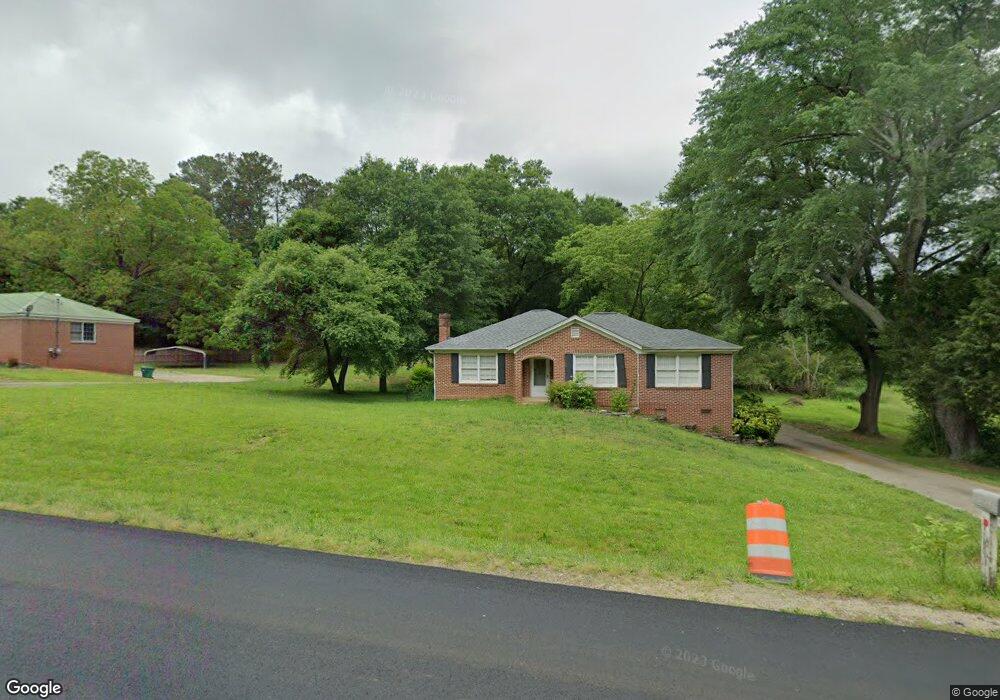
15870 Highway 59 Carnesville, GA 30521
Estimated Value: $173,000 - $263,000
--
Bed
2
Baths
1,358
Sq Ft
$155/Sq Ft
Est. Value
About This Home
This home is located at 15870 Highway 59, Carnesville, GA 30521 and is currently estimated at $210,062, approximately $154 per square foot. 15870 Highway 59 is a home located in Franklin County with nearby schools including Franklin County High School.
Ownership History
Date
Name
Owned For
Owner Type
Purchase Details
Closed on
Aug 20, 2021
Sold by
Harmon Tammy M
Bought by
Threatt Larry and Threatt Martha
Current Estimated Value
Purchase Details
Closed on
Sep 21, 2004
Sold by
Barron Dennis and Barron Alta
Bought by
Harmon Tammy M and Harmon Archie
Purchase Details
Closed on
Oct 5, 2001
Sold by
Wilbanks Doris M
Bought by
Barron Dennis and Barron Alta
Purchase Details
Closed on
Apr 14, 1995
Bought by
Wilbanks Doris M
Create a Home Valuation Report for This Property
The Home Valuation Report is an in-depth analysis detailing your home's value as well as a comparison with similar homes in the area
Home Values in the Area
Average Home Value in this Area
Purchase History
| Date | Buyer | Sale Price | Title Company |
|---|---|---|---|
| Threatt Larry | $55,150 | -- | |
| Harmon Tammy M | $87,000 | -- | |
| Barron Dennis | $75,000 | -- | |
| Wilbanks Doris M | -- | -- |
Source: Public Records
Tax History Compared to Growth
Tax History
| Year | Tax Paid | Tax Assessment Tax Assessment Total Assessment is a certain percentage of the fair market value that is determined by local assessors to be the total taxable value of land and additions on the property. | Land | Improvement |
|---|---|---|---|---|
| 2024 | $1,405 | $54,359 | $2,540 | $51,819 |
| 2023 | $1,399 | $49,417 | $2,309 | $47,108 |
| 2022 | $1,263 | $44,594 | $1,787 | $42,807 |
| 2021 | $1,103 | $38,861 | $1,787 | $37,074 |
| 2020 | $910 | $31,830 | $1,787 | $30,043 |
| 2019 | $882 | $31,830 | $1,787 | $30,043 |
| 2018 | $763 | $27,807 | $2,271 | $25,536 |
| 2017 | $791 | $27,807 | $2,271 | $25,536 |
| 2016 | $739 | $25,171 | $2,271 | $22,900 |
| 2015 | -- | $25,171 | $2,271 | $22,900 |
| 2014 | -- | $25,651 | $2,271 | $23,380 |
| 2013 | -- | $26,118 | $2,270 | $23,847 |
Source: Public Records
Map
Nearby Homes
- 7 Crest View Cir
- 210 Nora Moss Ln
- 110 Adaline Ct
- 735 Bowersville Rd
- 7690 Royston Rd
- 5821 Georgia 320
- 0 Manley St Unit 10611784
- 10170 Lavonia Rd
- 228 Franklin Hills Dr
- 228 Franklin Hills Dr Unit B14
- 340 Telford Rd
- 0 Turkey Creek Rd Unit 10589237
- 110 Telford Rd
- 1845 Old Stagecoach Rd
- 2556 Turkey Creek Rd
- 0 Georgia 198
- 456 Aderhold Rd
- 00 Hall Carson Rd
- 499 Aderhold Rd
- 1079 Hardeman Farm Rd