
Seller's Agent in 2026
Kenny Mayle
RE/MAX
(330) 446-0241
2 in this area
212 Total Sales
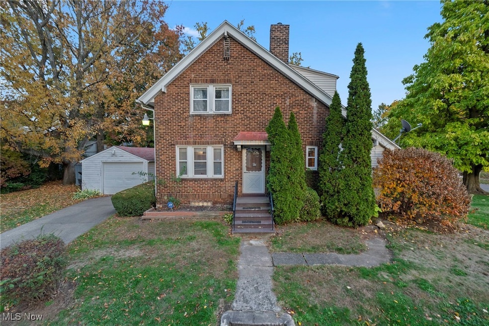


This brick beauty delivers timeless character and the kind of warmth you want heading into winter. Step inside to a bright, inviting living room complete with a decorative fireplace—ideal for hanging stockings or winding down after a long day. The adjoining dining area and kitchen keep things functional, with plenty of cabinet space and a layout ready for your modern touch. Upstairs, spacious bedrooms and a full bath showcase vintage details and sturdy craftsmanship. Downstairs, you’ll find bonus space for storage, hobbies, or your future rec room setup. Outside, mature trees frame the yard while a detached garage keeps your car snow-free all season. A covered back porch offers the perfect spot for morning coffee bundled in a blanket or spring-ready updates when the weather turns. Move in and stay cozy, or roll up your sleeves and make it your winter project—either way, this home offers comfort, potential, and that classic Akron charm that never goes out of style.
**During inspection a small leak was found on roof over sunroom addition**
Last Agent to Sell the Property
RE/MAX Edge Realty Brokerage Email: Kenny@kennysellsohio.com, 330-446-0241 License #2021000833 Listed on: 11/05/2025
| Date | Type | Sale Price | Title Company |
|---|---|---|---|
| Deed | $75,121 | None Listed On Document | |
| Interfamily Deed Transfer | -- | None Available | |
| Deed | $62,500 | -- |
| Date | Status | Loan Amount | Loan Type |
|---|---|---|---|
| Previous Owner | $32,500 | New Conventional |
| Date | Event | Price | List to Sale | Price per Sq Ft |
|---|---|---|---|---|
| 01/21/2026 01/21/26 | Sold | $75,121 | -16.4% | $68 / Sq Ft |
| 01/15/2026 01/15/26 | Pending | -- | -- | -- |
| 01/07/2026 01/07/26 | For Sale | $89,900 | 0.0% | $81 / Sq Ft |
| 12/21/2025 12/21/25 | Pending | -- | -- | -- |
| 12/16/2025 12/16/25 | For Sale | $89,900 | 0.0% | $81 / Sq Ft |
| 12/02/2025 12/02/25 | Pending | -- | -- | -- |
| 11/18/2025 11/18/25 | Price Changed | $89,900 | -10.0% | $81 / Sq Ft |
| 11/05/2025 11/05/25 | For Sale | $99,900 | -- | $90 / Sq Ft |
| Year | Tax Paid | Tax Assessment Tax Assessment Total Assessment is a certain percentage of the fair market value that is determined by local assessors to be the total taxable value of land and additions on the property. | Land | Improvement |
|---|---|---|---|---|
| 2025 | $1,216 | $29,156 | $7,886 | $21,270 |
| 2024 | $1,216 | $29,156 | $7,886 | $21,270 |
| 2023 | $1,216 | $29,156 | $7,886 | $21,270 |
| 2022 | $989 | $20,983 | $5,593 | $15,390 |
| 2021 | $990 | $20,983 | $5,593 | $15,390 |
| 2020 | $977 | $20,980 | $5,590 | $15,390 |
| 2019 | $965 | $19,680 | $5,650 | $14,030 |
| 2018 | $954 | $19,680 | $5,650 | $14,030 |
| 2017 | $966 | $19,680 | $5,650 | $14,030 |
| 2016 | $967 | $19,680 | $5,650 | $14,030 |
| 2015 | $966 | $19,680 | $5,650 | $14,030 |
| 2014 | $960 | $19,680 | $5,650 | $14,030 |
| 2013 | $1,065 | $21,450 | $5,650 | $15,800 |
Seller's Agent in 2026
Kenny Mayle
RE/MAX
(330) 446-0241
2 in this area
212 Total Sales
Buyer's Agent in 2026
Michelle Sanders
Cutler Real Estate
(330) 802-0989
5 in this area
74 Total Sales
Source: MLS Now
MLS Number: 5170034
APN: 67-24693
Disclaimer: Certain information contained herein is derived from information provided by parties other than Homes.com. All information provided is deemed reliable, but is not guaranteed to be accurate and should be independently verified.
![]() IDX information is provided exclusively for personal, non-commercial use, and may not be used for any purpose other than to identify prospective properties consumers may be interested in purchasing. Information is deemed reliable but not guaranteed.
IDX information is provided exclusively for personal, non-commercial use, and may not be used for any purpose other than to identify prospective properties consumers may be interested in purchasing. Information is deemed reliable but not guaranteed.
Ask me questions while you tour the home.