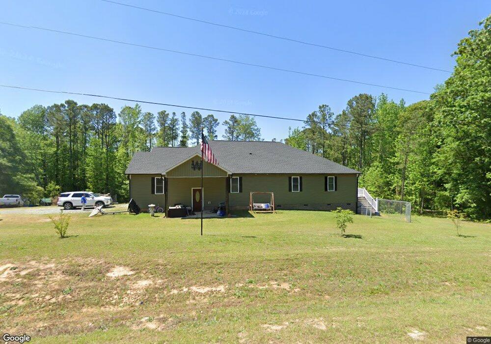
159 Byrdtown Rd Benson, NC 27504
Elevation NeighborhoodEstimated Value: $427,872 - $472,000
About This Home
This home is located at 159 Byrdtown Rd, Benson, NC 27504 and is currently estimated at $448,218, approximately $188 per square foot. 159 Byrdtown Rd is a home with nearby schools including Benson Elementary School, Benson Middle School, and South Johnston High School.
Ownership History
We collect this data history from publicly available records. To have your information removed, we recommend requesting removal directly through your county’s website.
Purchase Details
Home Financials for this Owner
Home Financials are based on the most recent Mortgage that was taken out on this home.Home Values in the Area
Average Home Value in this Area
Purchase History
We collect this data history from publicly available records. To have your information removed, we recommend requesting removal directly through your county’s website.
| Date | Buyer | Sale Price | Title Company |
|---|---|---|---|
| -- | None Available |
Mortgage History
We collect this data history from publicly available records. To have your information removed, we recommend requesting removal directly through your county’s website.
| Date | Status | Borrower | Loan Amount |
|---|---|---|---|
| Closed | $252,000 |
Tax History
We collect this data history from publicly available records. To have your information removed, we recommend requesting removal directly through your county’s website.
| Year | Tax Paid | Tax Assessment Tax Assessment Total Assessment is a certain percentage of the fair market value that is determined by local assessors to be the total taxable value of land and additions on the property. | Land | Improvement |
|---|---|---|---|---|
| 2025 | $2,720 | $428,360 | $74,300 | $354,060 |
| 2024 | $2,258 | $278,730 | $35,290 | $243,440 |
| 2023 | $2,202 | $278,730 | $35,290 | $243,440 |
| 2022 | $2,313 | $278,730 | $35,290 | $243,440 |
| 2021 | $2,313 | $278,730 | $35,290 | $243,440 |
| 2020 | $2,397 | $278,730 | $35,290 | $243,440 |
| 2019 | $2,397 | $278,730 | $35,290 | $243,440 |
| 2018 | $245 | $27,860 | $27,860 | $0 |
| 2017 | $210 | $23,850 | $23,850 | $0 |
| 2016 | $210 | $23,850 | $23,850 | $0 |
| 2015 | $210 | $23,850 | $23,850 | $0 |
| 2014 | $210 | $23,850 | $23,850 | $0 |
Map
- 200 Kissington Way
- 87 Sun Meadow Cir
- 243 Kissington Way
- 112 Kissington Way
- 76 Shadybrook Dr
- 292 Weddington Way
- 3032 Federal Rd
- 255 Ravens Row Dr
- 0 Woodall Dairy Rd Unit 10166450
- 25 W American Marigold Dr
- 291 White Azalea Way
- 311 White Azalea Way
- 337 White Azalea Way
- 272 White Azalea Way
- 236 White Azalea Way
- 236 White Azalea Way Unit 76
- 294 White Azalea Way Unit 74
- 294 White Azalea Way
- 2660 Nc 242 N
- 354 White Azalea Way
- 203 Byrdtown Rd
- 155 Byrdtown Rd
- 155 Byrd Town Rd
- 295 Byrdtown Rd
- 295 Byrdtown Rd
- 295 Byrdtown Rd Unit 694
- 63 Byrdtown Rd
- 0 Byrdtown Rd
- 353 Byrdtown Rd
- 2128 Woodall Dairy Rd
- 2150 Woodall Dairy Rd
- 2099 Woodall Dairy Rd
- 2065 Woodall Dairy Rd
- 2131 Woodall Dairy Rd
- 469 Byrdtown Rd
- 2216 Woodall Dairy Rd
- 587 Byrdtown Rd
- 119 Westside Dr
- 105 Westside Dr
- 115 Westside Dr
Ask me questions while you tour the home.