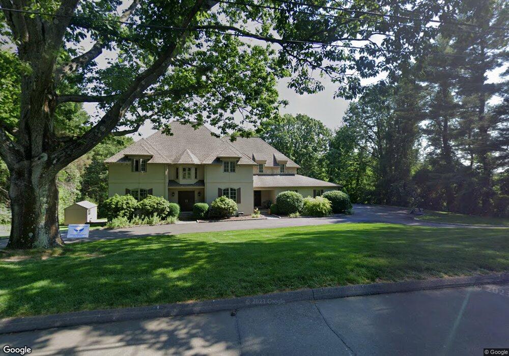
159 Field Rock Rd Southport, CT 06890
Estimated Value: $2,159,000 - $2,613,000
4
Beds
6
Baths
3,717
Sq Ft
$623/Sq Ft
Est. Value
About This Home
This home is located at 159 Field Rock Rd, Southport, CT 06890 and is currently estimated at $2,316,547, approximately $623 per square foot. 159 Field Rock Rd is a home located in Fairfield County with nearby schools including Mill Hill School, Roger Ludlowe Middle School, and Fairfield Ludlowe High School.
Ownership History
Date
Name
Owned For
Owner Type
Purchase Details
Closed on
Oct 9, 2007
Sold by
Gerson Barri and Gerson Stuart M
Bought by
Morgan Jason P and Morgan Jennifer
Current Estimated Value
Purchase Details
Closed on
Apr 15, 1993
Sold by
Riordan Eben M
Bought by
Gerson Stuart M and Gerson Barri
Create a Home Valuation Report for This Property
The Home Valuation Report is an in-depth analysis detailing your home's value as well as a comparison with similar homes in the area
Home Values in the Area
Average Home Value in this Area
Purchase History
| Date | Buyer | Sale Price | Title Company |
|---|---|---|---|
| Morgan Jason P | $1,620,000 | -- | |
| Morgan Jason P | $1,620,000 | -- | |
| Gerson Stuart M | $335,000 | -- | |
| Gerson Stuart M | $335,000 | -- |
Source: Public Records
Mortgage History
| Date | Status | Borrower | Loan Amount |
|---|---|---|---|
| Open | Gerson Stuart M | $840,000 | |
| Closed | Gerson Stuart M | $925,000 |
Source: Public Records
Tax History Compared to Growth
Tax History
| Year | Tax Paid | Tax Assessment Tax Assessment Total Assessment is a certain percentage of the fair market value that is determined by local assessors to be the total taxable value of land and additions on the property. | Land | Improvement |
|---|---|---|---|---|
| 2025 | $25,738 | $906,570 | $440,230 | $466,340 |
| 2024 | $25,293 | $906,570 | $440,230 | $466,340 |
| 2023 | $24,940 | $906,570 | $440,230 | $466,340 |
| 2022 | $24,695 | $906,570 | $440,230 | $466,340 |
| 2021 | $24,459 | $906,570 | $440,230 | $466,340 |
| 2020 | $27,282 | $1,018,360 | $435,680 | $582,680 |
| 2019 | $27,282 | $1,018,360 | $435,680 | $582,680 |
| 2018 | $26,844 | $1,018,360 | $435,680 | $582,680 |
| 2017 | $26,294 | $1,018,360 | $435,680 | $582,680 |
| 2016 | $25,917 | $1,018,360 | $435,680 | $582,680 |
| 2015 | $26,325 | $1,061,900 | $459,830 | $602,070 |
| 2014 | $25,910 | $1,061,900 | $459,830 | $602,070 |
Source: Public Records
Map
Nearby Homes
- 11 Twin Brooks Ln
- 1135 Mill Hill Rd
- 254 Sherwood Farm Rd
- 232 Pell Meadow Dr
- 160 Hunter Rd
- 83 Pell Meadow Dr
- 214 Henry St
- 1477 Mill Plain Rd
- 52 Glover St
- 647 Bronson Rd
- 175 Alma Dr
- 172 Sycamore Ln
- 2683 Bronson Rd
- 245 Taunton Rd
- 844 Mill Hill Terrace
- 688 Hulls Farm Rd
- 260 Range Rd
- 93 Millspaugh Dr
- 53 Hilltop Dr
- 46 Middlebrook Dr
- 127 Field Rock Rd
- 92 Field Rock Rd
- 180 Field Rock Rd
- 191 Field Rock Rd
- 211 Warner Hill Rd
- 1677 Bronson Rd
- 93 Field Rock Rd
- 170 Warner Hill Rd
- 265 Warner Hill Rd
- 1785 Bronson Rd
- 1700 Bronson Rd
- 1731 Bronson Rd
- 270 Warner Hill Rd
- 1625 Bronson Rd
- 1573 Bronson Rd
- 32 Field Rock Rd
- 45 Field Rock Rd
- 1660 Bronson Rd
- 1642 Bronson Rd
- 29 Cedar Rd