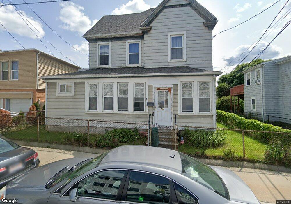
159 Locust St Winthrop, MA 02152
Winthrop Beach NeighborhoodEstimated Value: $772,496 - $934,000
About This Home
This home is located at 159 Locust St, Winthrop, MA 02152 and is currently estimated at $842,124, approximately $349 per square foot. 159 Locust St is a home located in Suffolk County with nearby schools including William P. Gorman/Fort Banks Elementary School, Arthur T. Cummings Elementary School, and Winthrop Middle School.
Ownership History
We collect this data history from publicly available records. To have your information removed, we recommend requesting removal directly through your county’s website.
Purchase Details
Home Values in the Area
Average Home Value in this Area
Purchase History
We collect this data history from publicly available records. To have your information removed, we recommend requesting removal directly through your county’s website.
| Date | Buyer | Sale Price | Title Company |
|---|---|---|---|
| $68,750 | -- | ||
| $68,750 | -- | ||
| $68,750 | -- | ||
| $68,750 | -- |
Mortgage History
We collect this data history from publicly available records. To have your information removed, we recommend requesting removal directly through your county’s website.
| Date | Status | Borrower | Loan Amount |
|---|---|---|---|
| Previous Owner | $20,000 |
Tax History
We collect this data history from publicly available records. To have your information removed, we recommend requesting removal directly through your county’s website.
| Year | Tax Paid | Tax Assessment Tax Assessment Total Assessment is a certain percentage of the fair market value that is determined by local assessors to be the total taxable value of land and additions on the property. | Land | Improvement |
|---|---|---|---|---|
| 2025 | $7,271 | $704,600 | $383,000 | $321,600 |
| 2024 | $6,864 | $658,700 | $368,100 | $290,600 |
| 2023 | $7,403 | $691,900 | $372,800 | $319,100 |
| 2022 | $7,278 | $618,900 | $332,900 | $286,000 |
| 2021 | $7,093 | $559,400 | $297,300 | $262,100 |
| 2020 | $6,944 | $550,200 | $297,300 | $252,900 |
| 2019 | $6,800 | $515,900 | $274,000 | $241,900 |
| 2018 | $6,177 | $436,200 | $209,000 | $227,200 |
| 2017 | $5,515 | $382,700 | $177,600 | $205,100 |
| 2016 | $5,215 | $339,300 | $154,400 | $184,900 |
| 2015 | $4,642 | $323,700 | $149,900 | $173,800 |
| 2014 | $4,507 | $289,300 | $139,400 | $149,900 |
Map
- 10 Beach Rd Unit 1
- 140 Shirley St Unit 230
- 140 Shirley St Unit 210
- 140 Shirley St Unit 320
- 173 Shirley St Unit 2
- 189 Shirley St Unit 1
- 43 Sagamore Ave Unit 1
- 52 Trident Ave Unit 52
- 21 Hutchinson St Unit 1
- 30 Hutchinson St
- 23 Sagamore Ave
- 53 Trident Ave Unit 301
- 53 Trident Ave Unit 303
- 47 Highland Ave
- 26 Shirley St Unit B
- 117 Revere St
- 304 Shirley St
- 26 Forrest St Unit 1
- 105 Oceanview St
- 300 Governors Dr Unit 21
- 240 Winthrop Shore Dr
- 239 Winthrop Shore Dr
- 6 Laurel Path Unit 2
- 6 Laurel Path
- 6 Laurel Path Unit 1
- 153 Locust St
- 242 Winthrop Shore Dr Unit 3
- 242 Winthrop Shore Dr Unit 2
- 242 Winthrop Shore Dr Unit 1
- 160 Locust St
- 238 Winthrop Shore Dr
- 244 Winthrop Shore Dr
- 149 Locust St Unit R
- 149 Locust St
- 149 Locust St Unit 1
- 149 Locust St Unit A
- 145 Locust St
- 145 Locust St Unit 1
- 235 Winthrop Shore Dr Unit 2
- 236 Winthrop Shore Dr
Ask me questions while you tour the home.