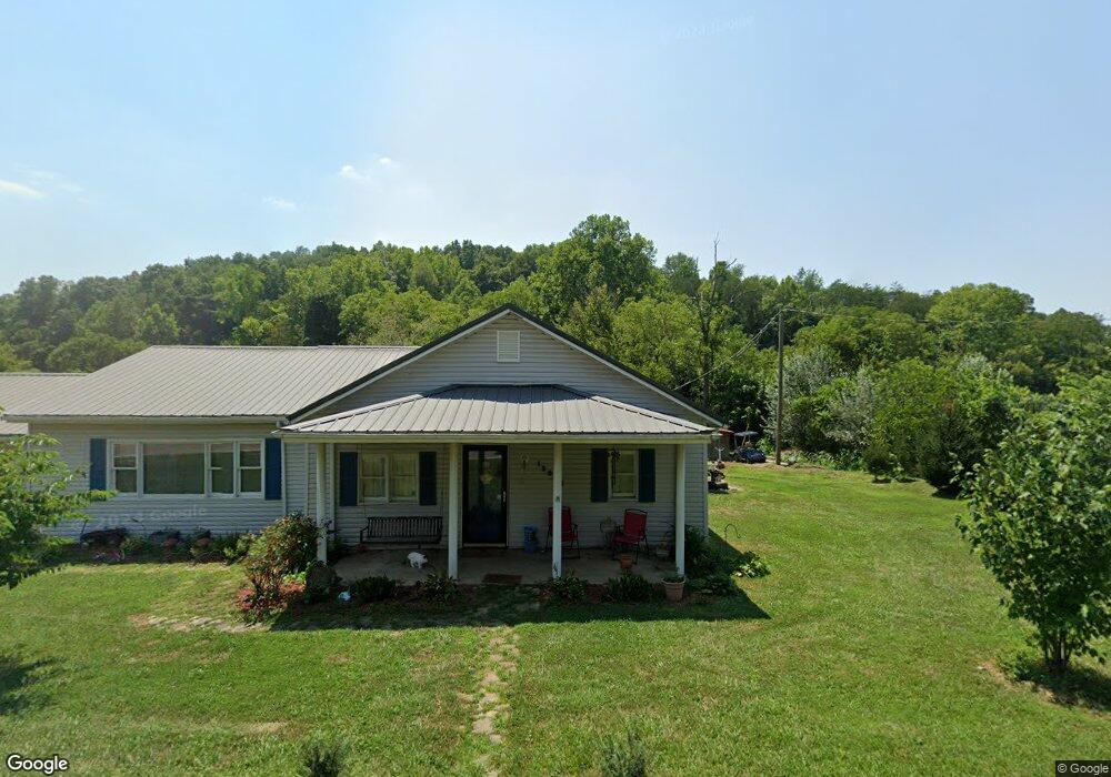
15903 State Route 775 Willow Wood, OH 45696
Estimated Value: $112,016 - $200,000
3
Beds
1
Bath
1,832
Sq Ft
$80/Sq Ft
Est. Value
About This Home
This home is located at 15903 State Route 775, Willow Wood, OH 45696 and is currently estimated at $146,004, approximately $79 per square foot. 15903 State Route 775 is a home located in Lawrence County with nearby schools including Symmes Valley Elementary School and Symmes Valley High School.
Ownership History
Date
Name
Owned For
Owner Type
Purchase Details
Closed on
Nov 2, 2015
Sold by
Pinkerman Karen and Miller Karen
Bought by
Taylor Joshua L and Taylor Sarah B
Current Estimated Value
Home Financials for this Owner
Home Financials are based on the most recent Mortgage that was taken out on this home.
Original Mortgage
$85,347
Outstanding Balance
$67,198
Interest Rate
3.82%
Mortgage Type
New Conventional
Estimated Equity
$78,806
Purchase Details
Closed on
Dec 23, 1993
Sold by
Pinkerman William E
Bought by
Miller Karen
Purchase Details
Closed on
Feb 25, 1988
Sold by
Cade Gary Ray and Cade Cheryl J
Bought by
Pinkerman William E
Create a Home Valuation Report for This Property
The Home Valuation Report is an in-depth analysis detailing your home's value as well as a comparison with similar homes in the area
Home Values in the Area
Average Home Value in this Area
Purchase History
| Date | Buyer | Sale Price | Title Company |
|---|---|---|---|
| Taylor Joshua L | $82,000 | Attorney | |
| Miller Karen | -- | -- | |
| Pinkerman William E | $42,800 | -- |
Source: Public Records
Mortgage History
| Date | Status | Borrower | Loan Amount |
|---|---|---|---|
| Open | Taylor Joshua L | $85,347 |
Source: Public Records
Tax History Compared to Growth
Tax History
| Year | Tax Paid | Tax Assessment Tax Assessment Total Assessment is a certain percentage of the fair market value that is determined by local assessors to be the total taxable value of land and additions on the property. | Land | Improvement |
|---|---|---|---|---|
| 2024 | -- | $25,290 | $1,790 | $23,500 |
| 2023 | $701 | $25,290 | $1,790 | $23,500 |
| 2022 | $699 | $25,290 | $1,790 | $23,500 |
| 2021 | $540 | $19,550 | $1,550 | $18,000 |
| 2020 | $555 | $19,550 | $1,550 | $18,000 |
| 2019 | $584 | $19,550 | $1,550 | $18,000 |
| 2018 | $570 | $18,930 | $1,550 | $17,380 |
| 2017 | $571 | $18,930 | $1,550 | $17,380 |
| 2016 | $527 | $18,930 | $1,550 | $17,380 |
| 2015 | $576 | $20,600 | $1,560 | $19,040 |
| 2014 | $576 | $20,600 | $1,560 | $19,040 |
| 2013 | $576 | $20,600 | $1,560 | $19,040 |
Source: Public Records
Map
Nearby Homes
- 0 Ohio 775
- 18325 State Route 141
- 1102 County Road 8
- 321 Township Road 75 S
- 266 Twp Rd 209
- 174 Township Road 74
- 168 Township Road 122 W
- 0 Ohio 141
- 13498 County Road 2
- 0 Venisonham-Camp Branch Rd Unit Tract 2
- 0 Venisonham-Camp Branch Rd Unit Tract 1
- 0 Venisonham-Camp Branch Rd
- 0 Venisonham-Camp Branch Rd Unit 25766693
- 0 Venisonham-Camp Branch Rd Unit 3
- 7381 County Road 16
- 479 Township Road 122
- 0 County Road 213
- 784 Township Road 209
- 810 Township Road 141
- 0 Dillon Ridge Unit 23651508