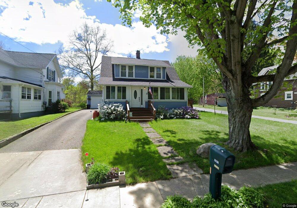
15911 Grove St Middlefield, OH 44062
Estimated Value: $162,000 - $225,000
3
Beds
1
Bath
1,200
Sq Ft
$157/Sq Ft
Est. Value
About This Home
This home is located at 15911 Grove St, Middlefield, OH 44062 and is currently estimated at $188,293, approximately $156 per square foot. 15911 Grove St is a home located in Geauga County with nearby schools including Jordak Elementary School, Cardinal Middle School, and Cardinal High School.
Ownership History
Date
Name
Owned For
Owner Type
Purchase Details
Closed on
May 22, 2003
Sold by
Decaro Frank J and Decaro Coreen T
Bought by
Vinecourt Amy J
Current Estimated Value
Home Financials for this Owner
Home Financials are based on the most recent Mortgage that was taken out on this home.
Original Mortgage
$93,200
Outstanding Balance
$40,978
Interest Rate
5.95%
Mortgage Type
Purchase Money Mortgage
Estimated Equity
$147,315
Purchase Details
Closed on
Aug 28, 2000
Sold by
Wilbraham Robert L and Wilbraham Kathleen R
Bought by
Decaro Frank J and Decaro Coreen T
Home Financials for this Owner
Home Financials are based on the most recent Mortgage that was taken out on this home.
Original Mortgage
$85,500
Interest Rate
8.26%
Purchase Details
Closed on
Jan 1, 1990
Bought by
Wilbraham Robert L
Create a Home Valuation Report for This Property
The Home Valuation Report is an in-depth analysis detailing your home's value as well as a comparison with similar homes in the area
Home Values in the Area
Average Home Value in this Area
Purchase History
| Date | Buyer | Sale Price | Title Company |
|---|---|---|---|
| Vinecourt Amy J | $116,500 | Executive Title Agency Corp | |
| Decaro Frank J | $92,000 | Lawyers Title Ins Corp | |
| Wilbraham Robert L | -- | -- |
Source: Public Records
Mortgage History
| Date | Status | Borrower | Loan Amount |
|---|---|---|---|
| Open | Vinecourt Amy J | $93,200 | |
| Previous Owner | Decaro Frank J | $85,500 | |
| Closed | Vinecourt Amy J | $17,475 |
Source: Public Records
Tax History Compared to Growth
Tax History
| Year | Tax Paid | Tax Assessment Tax Assessment Total Assessment is a certain percentage of the fair market value that is determined by local assessors to be the total taxable value of land and additions on the property. | Land | Improvement |
|---|---|---|---|---|
| 2024 | $1,873 | $48,720 | $7,910 | $40,810 |
| 2023 | $1,873 | $48,720 | $7,910 | $40,810 |
| 2022 | $1,881 | $40,400 | $6,550 | $33,850 |
| 2021 | $1,885 | $40,400 | $6,550 | $33,850 |
| 2020 | $1,946 | $40,400 | $6,550 | $33,850 |
| 2019 | $1,863 | $35,740 | $6,550 | $29,190 |
| 2018 | $1,862 | $35,740 | $6,550 | $29,190 |
| 2017 | $1,863 | $35,740 | $6,550 | $29,190 |
| 2016 | $1,616 | $35,500 | $6,550 | $28,950 |
| 2015 | $1,443 | $35,500 | $6,550 | $28,950 |
| 2014 | $1,443 | $35,500 | $6,550 | $28,950 |
| 2013 | $1,426 | $35,500 | $6,550 | $28,950 |
Source: Public Records
Map
Nearby Homes
- 16008 Button St
- 15660 Georgia Rd
- 14706 Steeplechase Dr
- 16298 Weathervane Dr
- 15142 Sawgrass Ln
- 15791 Madison Rd
- 16310 Madison Rd
- 14607 Erwin Dr
- 15720 Jug Rd
- 14752 Evergreen Dr
- 14028 Goodwin St
- 16765 Old State Rd
- 13829 Carlton St
- 13888 Goodwin St
- 13105 Madison Rd
- 13137 Old State Rd
- V/L Rapids Rd
- 16510 Bundysburg Rd
- 13565 Colony Ln
- 8070 Parkman Mesopotamia Rd
- 15915 Grove St
- 15901 Grove St
- 15921 Grove St
- 15905 Grove St
- 15914 Grove St
- 15893 Grove St Unit 1128
- 15893 Grove St
- 15082 S State Ave Unit S
- 15890 Grove St
- 15074 S State Ave Unit S
- 15074 S State Ave
- 15910 Grove St
- 15900 Grove St
- 15060 S State Ave
- 15884 Grove St
- 15885 Grove St
- 15054 S State Ave
- 15090 S State Ave
- 15048 S State Ave
- 15098 S State Ave