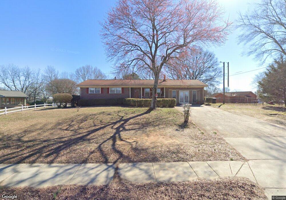
1593 Irwin Bridge Rd NW Unit I Conyers, GA 30012
Estimated Value: $221,512 - $235,000
3
Beds
3
Baths
1,703
Sq Ft
$136/Sq Ft
Est. Value
About This Home
This home is located at 1593 Irwin Bridge Rd NW Unit I, Conyers, GA 30012 and is currently estimated at $231,128, approximately $135 per square foot. 1593 Irwin Bridge Rd NW Unit I is a home located in Rockdale County with nearby schools including Pine Street Elementary School, Conyers Middle School, and Rockdale County High School.
Ownership History
Date
Name
Owned For
Owner Type
Purchase Details
Closed on
Oct 28, 1998
Sold by
Burns Darrell E and Burns Joel E
Bought by
Brown Lorenzo and Brown Ruby Nell
Current Estimated Value
Home Financials for this Owner
Home Financials are based on the most recent Mortgage that was taken out on this home.
Original Mortgage
$73,870
Outstanding Balance
$16,152
Interest Rate
6.61%
Mortgage Type
FHA
Estimated Equity
$214,976
Purchase Details
Closed on
Jun 5, 1998
Sold by
Moore Arthur and Moore Ola Mae
Bought by
Burns Darrell E and Burns Joel E
Create a Home Valuation Report for This Property
The Home Valuation Report is an in-depth analysis detailing your home's value as well as a comparison with similar homes in the area
Home Values in the Area
Average Home Value in this Area
Purchase History
| Date | Buyer | Sale Price | Title Company |
|---|---|---|---|
| Brown Lorenzo | $75,900 | -- | |
| Burns Darrell E | -- | -- |
Source: Public Records
Mortgage History
| Date | Status | Borrower | Loan Amount |
|---|---|---|---|
| Open | Brown Lorenzo | $73,870 |
Source: Public Records
Tax History Compared to Growth
Tax History
| Year | Tax Paid | Tax Assessment Tax Assessment Total Assessment is a certain percentage of the fair market value that is determined by local assessors to be the total taxable value of land and additions on the property. | Land | Improvement |
|---|---|---|---|---|
| 2024 | $2,564 | $87,480 | $18,200 | $69,280 |
| 2023 | $2,087 | $77,240 | $15,200 | $62,040 |
| 2022 | $1,857 | $63,080 | $12,240 | $50,840 |
| 2021 | $1,413 | $51,000 | $9,120 | $41,880 |
| 2020 | $1,057 | $42,000 | $7,520 | $34,480 |
| 2019 | $855 | $37,200 | $5,280 | $31,920 |
| 2018 | $119 | $34,680 | $5,280 | $29,400 |
| 2017 | $459 | $26,880 | $4,160 | $22,720 |
| 2016 | $433 | $26,880 | $4,160 | $22,720 |
| 2015 | $22 | $21,080 | $2,680 | $18,400 |
| 2014 | $7 | $21,080 | $2,680 | $18,400 |
| 2013 | -- | $29,160 | $7,200 | $21,960 |
Source: Public Records
Map
Nearby Homes
- 1249 Pinedale Cir NW
- 1547 Mountain View Cir NW
- 995 Sigman Rd NW
- 1151 Pinedale Cir NW
- 1958 Millstream Hollow
- 2039 Wildflower Way NW
- 1890 Millstream Hollow
- 1558 Tanglewood Way NW
- 1650 Larkspur Trail
- 1211 Cedar Creek Ct NW
- 1606 Larkspur Trail
- 1740 Millstream Hollow
- 1586 Larkspur Trail
- 1215 Willow Creek Ct NW
- 1463 River Stone Trace
- 1432 Forest Villa Dr NW
- 1436 N Hicks Cir NW
- 2468 Rockbridge Rd NW
- 1791 Crestridge Cir NW
- 1074 Meadowbrook Ln NW
- 1061 Kingston Rd NW
- 1064 Meadowbrook Ln NW
- 1057 Kingston Rd NW
- 1084 Meadowbrook Ln NW
- 1058 Meadowbrook Ln NW
- 1047 Kingston Rd NW
- 1085 Meadowbrook Ln NW
- 1048 Meadowbrook Ln NW
- 1069 Meadowbrook Ln NW Unit 1
- 1060 Kingston Rd NW
- 1077 Meadowbrook Ln NW
- 1050 Kingston Rd NW Unit 1
- 1041 Kingston Rd NW
- 1059 Meadowbrook Ln NW
- 1038 Meadowbrook Ln NW
- 1040 Kingston Rd NW
- 1049 Meadowbrook Ln NW
- 1031 Kingston Rd NW
- 1101 Mountain View Rd NW