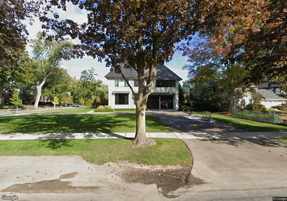
1598 Redding Rd Birmingham, MI 48009
Estimated Value: $3,148,000 - $3,743,000
4
Beds
7
Baths
5,176
Sq Ft
$651/Sq Ft
Est. Value
About This Home
This home is located at 1598 Redding Rd, Birmingham, MI 48009 and is currently estimated at $3,369,235, approximately $650 per square foot. 1598 Redding Rd is a home located in Oakland County with nearby schools including Pierce Elementary School, Derby Middle School, and Ernest W. Seaholm High School.
Ownership History
Date
Name
Owned For
Owner Type
Purchase Details
Closed on
Jul 31, 2017
Sold by
Reeder Bonnie E Heitsch and Reeder Bonnie E Heitsch
Bought by
Jaradi Avis J and Jaradi Marla A
Current Estimated Value
Home Financials for this Owner
Home Financials are based on the most recent Mortgage that was taken out on this home.
Original Mortgage
$520,000
Outstanding Balance
$423,506
Interest Rate
3.37%
Mortgage Type
Adjustable Rate Mortgage/ARM
Estimated Equity
$2,945,729
Purchase Details
Closed on
Sep 6, 2016
Sold by
Heitsch Lawrence D and Heitsch Elaine D
Bought by
Heitsch Bonnie E and Corrigan Cynthia Heitsch
Create a Home Valuation Report for This Property
The Home Valuation Report is an in-depth analysis detailing your home's value as well as a comparison with similar homes in the area
Home Values in the Area
Average Home Value in this Area
Purchase History
| Date | Buyer | Sale Price | Title Company |
|---|---|---|---|
| Jaradi Avis J | $650,000 | Title Connect Llc | |
| Heitsch Bonnie E | -- | None Available |
Source: Public Records
Mortgage History
| Date | Status | Borrower | Loan Amount |
|---|---|---|---|
| Open | Jaradi Avis J | $520,000 |
Source: Public Records
Tax History
| Year | Tax Paid | Tax Assessment Tax Assessment Total Assessment is a certain percentage of the fair market value that is determined by local assessors to be the total taxable value of land and additions on the property. | Land | Improvement |
|---|---|---|---|---|
| 2025 | $56,100 | $1,526,390 | $0 | $0 |
| 2024 | $49,523 | $1,508,820 | $0 | $0 |
| 2023 | $47,455 | $1,430,710 | $0 | $0 |
| 2022 | $50,881 | $1,341,190 | $0 | $0 |
| 2021 | $36,860 | $1,234,900 | $0 | $0 |
| 2020 | $26,818 | $642,300 | $0 | $0 |
| 2019 | $16,357 | $310,330 | $0 | $0 |
| 2018 | $27,316 | $517,620 | $0 | $0 |
| 2017 | $13,249 | $530,190 | $0 | $0 |
| 2016 | $13,273 | $509,500 | $0 | $0 |
| 2015 | -- | $480,880 | $0 | $0 |
| 2014 | -- | $401,870 | $0 | $0 |
| 2011 | -- | $281,810 | $0 | $0 |
Source: Public Records
Map
Nearby Homes
- 1444 Fairfax St
- 1183 Puritan Ave
- 1094 Suffield Ave
- 1551 Lakeside Dr
- 1295 Lakeside Dr
- 1120 Lyonhurst St
- 1115 N Old Woodward Ave Unit 52
- 1115 N Old Woodward Ave Unit 61
- 1115 N Old Woodward #76 Ave
- 1115 N Old Woodward Ave
- 1111 N Old Woodward Ave Unit 4
- 1111 N Old Woodward Ave Unit 23
- 363 Lakewood Dr
- 341 Lowell Ct
- 750 Hazelwood St
- 670 Oak Ave
- 1882 Melbourne St
- 592 Lakeside Dr
- 0000 Brookdale Rd
- 488 Vinewood Ave
- 1592 Redding Rd
- 1450 Pilgrim Ave
- 1431 Pilgrim Ave
- 1405 Pilgrim Ave
- 1586 Redding Rd
- 1394 Pilgrim Ave
- 1459 Pilgrim Ave
- 1470 Pilgrim Ave
- 1497 Pilgrim Ave
- 1389 Pilgrim Ave
- 1365 Puritan Ave
- 1370 Pilgrim Ave
- 1420 Suffield Ave
- 1480 Suffield Ave
- 1450 Redding Rd
- 1363 Pilgrim Ave
- 1334 Pilgrim Ave
- 1498 Suffield Ave
- 1355 Puritan Ave
- 1530 Pilgrim Ave
Your Personal Tour Guide
Ask me questions while you tour the home.