M
Landlord's Agent in 2025
Marika and Adam Real Estate Group
Hammond Residential Real Estate
1 in this area
25 Total Sales
Estimated Value: $1,701,445
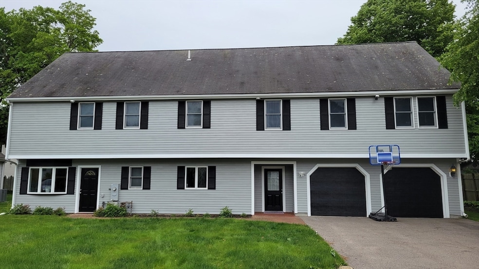
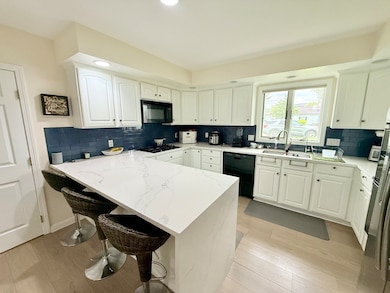
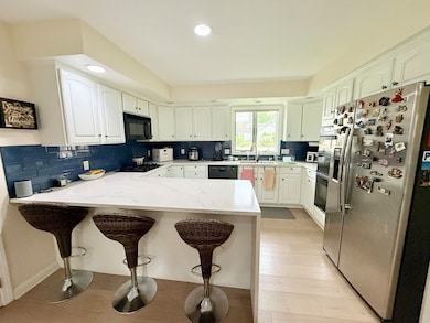
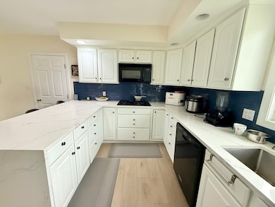
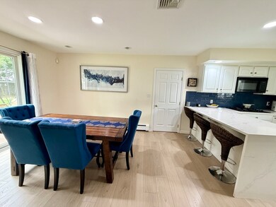
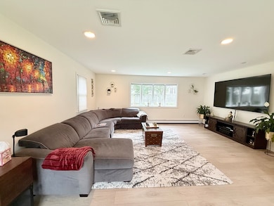
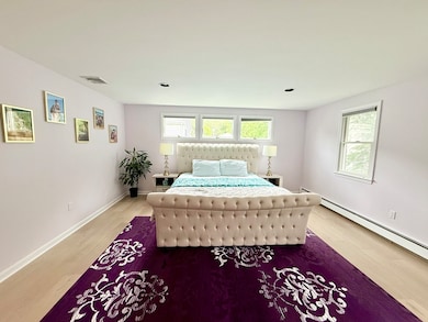
Located on a quiet cul-de-sac in desirable South Newton, this meticulously maintained 5-bedroom, 2.5-bath single family Colonial offers over 2,700 sq.ft. of living space and was substantially rebuilt in 1997. Enter through the foyer/mudroom with direct access to the driveway and oversized two-car garage with extra storage. The first floor features a bright, front-to-back living room and a fully renovated eat-in kitchen with gas cooktop, double ovens, microwave, dishwasher, breakfast bar, and abundant cabinet space. Upstairs, the spacious primary suite includes an oversized walk-in closet and en suite bath. Four additional bedrooms and a full laundry area complete the second floor. The attic, with 11' peak ceilings, provides excellent storage. Situated on a 7,096 sq.ft. level lot with a yard and patio, this home is close to top-rated schools, parks, conservation trails, and shopping. Convenient access to Route 9, the Pike, and public transportation. Available July 1.
Last Agent to Rent the Property
Marika and Adam Real Estate Group
Hammond Residential Real Estate Listed on: 06/06/2025

Last Renter's Agent
Marika and Adam Real Estate Group
Hammond Residential Real Estate Listed on: 06/06/2025
| Date | Buyer | Sale Price | Title Company |
|---|---|---|---|
| Sanjay-Bhatt Nishant | $1,299,000 | None Available | |
| Rosen B Mark | $62,000 | -- |
| Date | Status | Borrower | Loan Amount |
|---|---|---|---|
| Open | Sanjay-Bhatt Nishant | $1,039,200 | |
| Previous Owner | Rosen B Mark | $50,000 | |
| Previous Owner | Rosen B Mark | $227,000 | |
| Previous Owner | Rosen B Mark | $220,000 |
| Date | Event | Price | List to Sale | Price per Sq Ft |
|---|---|---|---|---|
| 08/01/2025 08/01/25 | Rented | $6,500 | -3.7% | -- |
| 06/12/2025 06/12/25 | Under Contract | -- | -- | -- |
| 06/06/2025 06/06/25 | For Rent | $6,750 | -- | -- |
| Year | Tax Paid | Tax Assessment Tax Assessment Total Assessment is a certain percentage of the fair market value that is determined by local assessors to be the total taxable value of land and additions on the property. | Land | Improvement |
|---|---|---|---|---|
| 2025 | $13,430 | $1,370,400 | $674,000 | $696,400 |
| 2024 | $12,986 | $1,330,500 | $654,400 | $676,100 |
| 2023 | $12,306 | $1,208,800 | $491,900 | $716,900 |
| 2022 | $10,202 | $969,800 | $455,500 | $514,300 |
| 2021 | $6,024 | $914,900 | $429,700 | $485,200 |
| 2020 | $9,552 | $914,900 | $429,700 | $485,200 |
| 2019 | $5,188 | $888,300 | $417,200 | $471,100 |
| 2018 | $8,910 | $823,500 | $378,700 | $444,800 |
| 2017 | $8,639 | $776,900 | $357,300 | $419,600 |
| 2016 | $8,263 | $726,100 | $333,900 | $392,200 |
| 2015 | $7,879 | $678,600 | $312,100 | $366,500 |
M
Landlord's Agent in 2025
Marika and Adam Real Estate Group
Hammond Residential Real Estate
1 in this area
25 Total Sales
Landlord's Co-Listing Agent in 2025
Adam Aroesty
Hammond Residential Real Estate
(617) 571-9843
26 Total Sales
Source: MLS Property Information Network (MLS PIN)
MLS Number: 73387055
APN: NEWT-000084-000004-000007
Disclaimer: Certain information contained herein is derived from information provided by parties other than Homes.com. All information provided is deemed reliable, but is not guaranteed to be accurate and should be independently verified.
![]() The property listing data and information, or the Images, set forth herein were provided to MLS Property Information Network, Inc. from third party sources, including sellers, lessors and public records, and were compiled by MLS Property Information Network, Inc. The property listing data and information, and the Images, are for the personal, non-commercial use of consumers having a good faith interest in purchasing or leasing listed properties of the type displayed to them and may not be used for any purpose other than to identify prospective properties which such consumers may have a good faith interest in purchasing or leasing. MLS Property Information Network, Inc. and its subscribers disclaim any and all representations and warranties as to the accuracy of the property listing data and information, or as to the accuracy of any of the Images, set forth herein.
The property listing data and information, or the Images, set forth herein were provided to MLS Property Information Network, Inc. from third party sources, including sellers, lessors and public records, and were compiled by MLS Property Information Network, Inc. The property listing data and information, and the Images, are for the personal, non-commercial use of consumers having a good faith interest in purchasing or leasing listed properties of the type displayed to them and may not be used for any purpose other than to identify prospective properties which such consumers may have a good faith interest in purchasing or leasing. MLS Property Information Network, Inc. and its subscribers disclaim any and all representations and warranties as to the accuracy of the property listing data and information, or as to the accuracy of any of the Images, set forth herein.