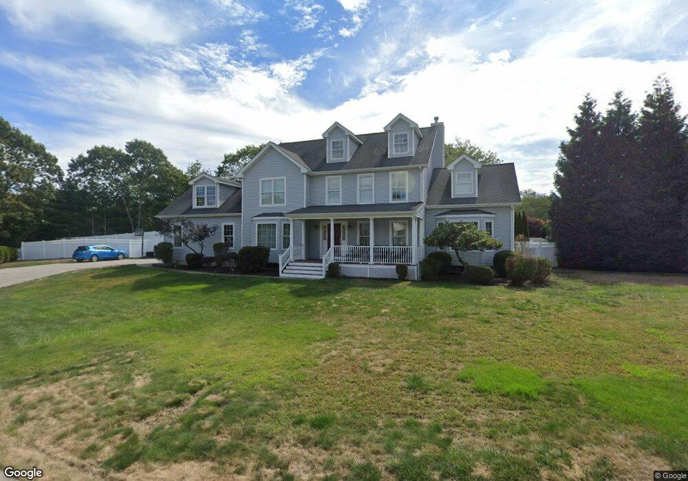
16 Brannegan Dr Pawcatuck, CT 06379
Estimated Value: $713,000 - $873,000
4
Beds
3
Baths
2,986
Sq Ft
$270/Sq Ft
Est. Value
About This Home
This home is located at 16 Brannegan Dr, Pawcatuck, CT 06379 and is currently estimated at $806,139, approximately $269 per square foot. 16 Brannegan Dr is a home located in New London County with nearby schools including Stonington Middle School, Stonington High School, and Pine Point School.
Ownership History
Date
Name
Owned For
Owner Type
Purchase Details
Closed on
May 28, 2009
Sold by
Lowry Kevin and Lowry Stacy
Bought by
Costanzo Steven T and Costanzo Carol R
Current Estimated Value
Home Financials for this Owner
Home Financials are based on the most recent Mortgage that was taken out on this home.
Original Mortgage
$315,000
Outstanding Balance
$200,092
Interest Rate
4.87%
Estimated Equity
$606,047
Purchase Details
Closed on
Dec 22, 2006
Sold by
Skirig Dev Inc
Bought by
Lowry Kevin and Lowry Stacy
Create a Home Valuation Report for This Property
The Home Valuation Report is an in-depth analysis detailing your home's value as well as a comparison with similar homes in the area
Home Values in the Area
Average Home Value in this Area
Purchase History
| Date | Buyer | Sale Price | Title Company |
|---|---|---|---|
| Costanzo Steven T | $475,000 | -- | |
| Costanzo Steven T | $475,000 | -- | |
| Lowry Kevin | $545,691 | -- | |
| Lowry Kevin | $545,691 | -- |
Source: Public Records
Mortgage History
| Date | Status | Borrower | Loan Amount |
|---|---|---|---|
| Open | Lowry Kevin | $315,000 | |
| Closed | Lowry Kevin | $315,000 | |
| Previous Owner | Lowry Kevin | $410,000 |
Source: Public Records
Tax History Compared to Growth
Tax History
| Year | Tax Paid | Tax Assessment Tax Assessment Total Assessment is a certain percentage of the fair market value that is determined by local assessors to be the total taxable value of land and additions on the property. | Land | Improvement |
|---|---|---|---|---|
| 2025 | $9,133 | $459,400 | $86,900 | $372,500 |
| 2024 | $8,752 | $459,400 | $86,900 | $372,500 |
| 2023 | $8,752 | $459,400 | $86,900 | $372,500 |
| 2022 | $7,473 | $291,800 | $65,900 | $225,900 |
| 2021 | $4,218 | $291,800 | $65,900 | $225,900 |
| 2020 | $7,342 | $291,800 | $65,900 | $225,900 |
| 2019 | $4,048 | $291,800 | $65,900 | $225,900 |
| 2018 | $7,079 | $291,800 | $65,900 | $225,900 |
| 2017 | $6,896 | $280,100 | $68,900 | $211,200 |
| 2016 | $6,708 | $280,100 | $68,900 | $211,200 |
| 2015 | $6,297 | $280,100 | $68,900 | $211,200 |
| 2014 | $6,159 | $280,100 | $68,900 | $211,200 |
Source: Public Records
Map
Nearby Homes
- 49 Lathrop Ave
- 2 Pawcatuck Ave
- 52 William St
- 52 Prospect St Unit B
- 13 Palmer St
- 38 Prospect St
- 65 Mechanic St
- 67 Renee Dr
- 0 River Unit 24129909
- 77 Mechanic St
- 12 Avery St
- 1 Millan Terrace
- 25 School St Unit 2
- 16 Summertime Cir
- 27 Liberty St
- 23 Abbey Ln Unit 12
- 24 Abbey Ln Unit 13
- 14 Summertime Cir
- Monroe Plan at The Enclave at Barn Island
- Lincoln Plan at The Enclave at Barn Island
- 35 Cronin Ave
- 10 Brannegan Dr
- 33 Cronin Ave
- 22 Brannegan Dr
- 29 Cronin Ave
- 15 Brannegan Dr
- 23 Shea Dr
- 11 Brannegan Dr
- 19 Brannegan Dr
- 27 Cronin Ave
- 9 Brannegan Rock Ridge Estates
- 9 Brannegan Dr
- 3 Brannegan Dr
- 00 Brannegan
- 1 Brannegan Dr
- 25 Cronin Ave
- 14 Blueberry Pond Dr
- 20 Blueberry Pond Dr
- 23 Cronin Ave
- 59 Parkwood Dr