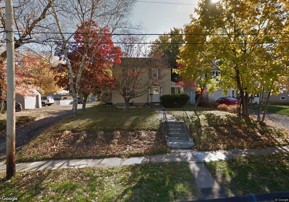
16 Byrd Rd Wethersfield, CT 06109
Estimated Value: $299,000 - $392,949
3
Beds
2
Baths
1,419
Sq Ft
$248/Sq Ft
Est. Value
About This Home
This home is located at 16 Byrd Rd, Wethersfield, CT 06109 and is currently estimated at $352,487, approximately $248 per square foot. 16 Byrd Rd is a home located in Hartford County with nearby schools including Alfred W. Hanmer School, Silas Deane Middle School, and Wethersfield High School.
Ownership History
Date
Name
Owned For
Owner Type
Purchase Details
Closed on
Jan 29, 2009
Sold by
Fdic
Bought by
Diaz Nereida
Current Estimated Value
Purchase Details
Closed on
Sep 18, 2008
Sold by
Volmar Emmanuel A
Bought by
Indymac Bank Fsb
Purchase Details
Closed on
May 12, 2004
Sold by
Wojtkowiak Cynthia
Bought by
Volmar Emmanuel A
Purchase Details
Closed on
Dec 28, 1995
Sold by
Cyo Allen and Traczyk Chrisitne
Bought by
Cavalieri Cynthia
Create a Home Valuation Report for This Property
The Home Valuation Report is an in-depth analysis detailing your home's value as well as a comparison with similar homes in the area
Home Values in the Area
Average Home Value in this Area
Purchase History
| Date | Buyer | Sale Price | Title Company |
|---|---|---|---|
| Diaz Nereida | $145,000 | -- | |
| Indymac Bank Fsb | -- | -- | |
| Volmar Emmanuel A | $172,500 | -- | |
| Cavalieri Cynthia | $116,500 | -- |
Source: Public Records
Mortgage History
| Date | Status | Borrower | Loan Amount |
|---|---|---|---|
| Previous Owner | Cavalieri Cynthia | $228,000 | |
| Previous Owner | Cavalieri Cynthia | $28,500 |
Source: Public Records
Tax History
| Year | Tax Paid | Tax Assessment Tax Assessment Total Assessment is a certain percentage of the fair market value that is determined by local assessors to be the total taxable value of land and additions on the property. | Land | Improvement |
|---|---|---|---|---|
| 2025 | $9,019 | $218,790 | $82,730 | $136,060 |
| 2024 | $6,588 | $152,420 | $65,100 | $87,320 |
| 2023 | $6,368 | $152,420 | $65,100 | $87,320 |
| 2022 | $6,261 | $152,420 | $65,100 | $87,320 |
| 2021 | $6,199 | $152,420 | $65,100 | $87,320 |
| 2020 | $6,202 | $152,420 | $65,100 | $87,320 |
| 2019 | $6,210 | $152,420 | $65,100 | $87,320 |
| 2018 | $6,272 | $153,800 | $62,900 | $90,900 |
| 2017 | $6,117 | $153,800 | $62,900 | $90,900 |
| 2016 | $5,927 | $153,800 | $62,900 | $90,900 |
| 2015 | $5,874 | $153,800 | $62,900 | $90,900 |
| 2014 | $5,651 | $153,800 | $62,900 | $90,900 |
Source: Public Records
Map
Nearby Homes
- 35 Stillwold Dr
- 108 Chamberlain Rd
- 91 Somerset St
- 87 Somerset St
- 195 Middletown Ave
- 137 Dale Rd
- 38 Wheeler Rd
- 31 Ox Yoke Dr
- 1 Fernwood St
- 317 Garden St Unit 319
- 116 Wells Farm Dr
- 89 Merriman Rd
- 455 Brimfield Rd
- 11 Charter Rd
- 18 Avalon Place
- 493 Main St
- 104 Willow St
- 20 Forest Dr
- 19 Albert Ave
- 48 Ridge Crest Cir
Your Personal Tour Guide
Ask me questions while you tour the home.