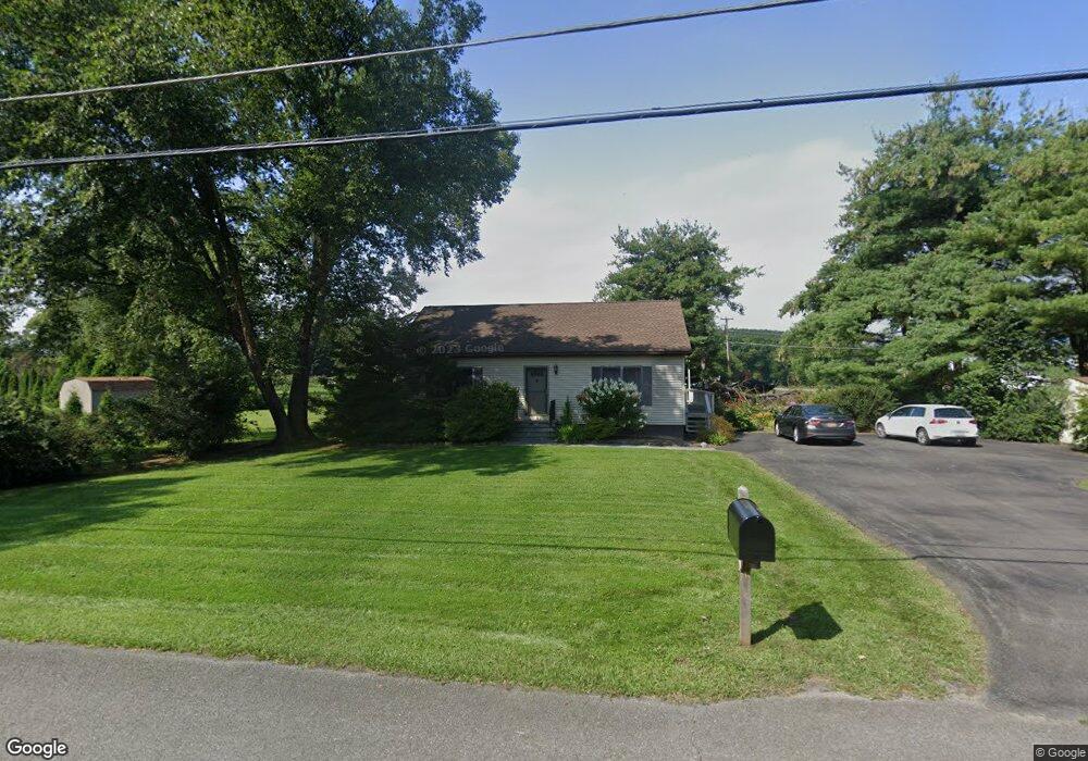
16 Clint Finger Rd Saugerties, NY 12477
Estimated Value: $343,000 - $386,000
2
Beds
2
Baths
1,120
Sq Ft
$328/Sq Ft
Est. Value
About This Home
This home is located at 16 Clint Finger Rd, Saugerties, NY 12477 and is currently estimated at $367,495, approximately $328 per square foot. 16 Clint Finger Rd is a home located in Ulster County with nearby schools including Saugerties Senior High School and Cerebral Palsy of Ulster County Preschool Program.
Ownership History
Date
Name
Owned For
Owner Type
Purchase Details
Closed on
Mar 14, 2012
Sold by
Holland David
Bought by
Holland Louise
Current Estimated Value
Purchase Details
Closed on
May 6, 2005
Sold by
Misasi Lisa M and Linnartz Jennifer A
Bought by
Holland Louise
Home Financials for this Owner
Home Financials are based on the most recent Mortgage that was taken out on this home.
Original Mortgage
$152,000
Outstanding Balance
$79,813
Interest Rate
5.95%
Mortgage Type
Fannie Mae Freddie Mac
Estimated Equity
$287,682
Create a Home Valuation Report for This Property
The Home Valuation Report is an in-depth analysis detailing your home's value as well as a comparison with similar homes in the area
Home Values in the Area
Average Home Value in this Area
Purchase History
| Date | Buyer | Sale Price | Title Company |
|---|---|---|---|
| Holland Louise | -- | -- | |
| Holland Louise | $182,000 | -- |
Source: Public Records
Mortgage History
| Date | Status | Borrower | Loan Amount |
|---|---|---|---|
| Open | Holland Louise | $152,000 |
Source: Public Records
Tax History Compared to Growth
Tax History
| Year | Tax Paid | Tax Assessment Tax Assessment Total Assessment is a certain percentage of the fair market value that is determined by local assessors to be the total taxable value of land and additions on the property. | Land | Improvement |
|---|---|---|---|---|
| 2024 | $6,486 | $311,500 | $64,000 | $247,500 |
| 2023 | $6,091 | $273,000 | $64,000 | $209,000 |
| 2022 | $5,974 | $233,000 | $64,000 | $169,000 |
| 2021 | $5,974 | $198,500 | $58,000 | $140,500 |
| 2020 | $5,273 | $178,500 | $52,000 | $126,500 |
| 2019 | $5,016 | $178,500 | $52,000 | $126,500 |
| 2018 | $5,092 | $173,000 | $52,000 | $121,000 |
| 2017 | $5,058 | $169,500 | $52,000 | $117,500 |
| 2016 | $5,044 | $169,500 | $52,000 | $117,500 |
| 2015 | -- | $169,500 | $74,000 | $95,500 |
| 2014 | -- | $169,500 | $74,000 | $95,500 |
Source: Public Records
Map
Nearby Homes
- TBD Glenerie Ln
- 30 Glenerie Ln
- 181 Glenerie Blvd
- 356 Old Stage Rd
- 12 Park Cir
- 10 Park Cir
- 2679 Route 9w
- 7 Country Club Dr
- 15 Dachenhausen Ln
- 688 Churchland Rd
- 188 Old Stage Rd
- 2771 U S 9w
- 18 Ridge Rd
- 15 Ruby Meadows Rd
- 17 Cedar Dr
- 6 Paupawey Ct
- 28 John Carle Rd
- 246 South Rd
- 125 Main St
- 132 Dutchtown Rd
- 15 Clint Finger Rd
- 570 Kings Hwy
- 20 Clint Finger Rd
- 21 Clint Finger Rd
- 557 Kings Hwy
- 31 Clint Finger Rd Unit . 2
- 31 Clint Finger Rd Unit . 1
- 31 Clint Finger Rd Unit 2
- 31 Clint Finger Rd
- 556 Kings Hwy
- 548 Kings Hwy
- 599 Kings Hwy
- 601 Kings Hwy
- 519 Kings Hwy
- 607 Kings Hwy
- 504 Kings Hwy
- 609 Kings Hwy
- 513 Kings Hwy
- 611 Kings Hwy
- 611 Kings Hwy