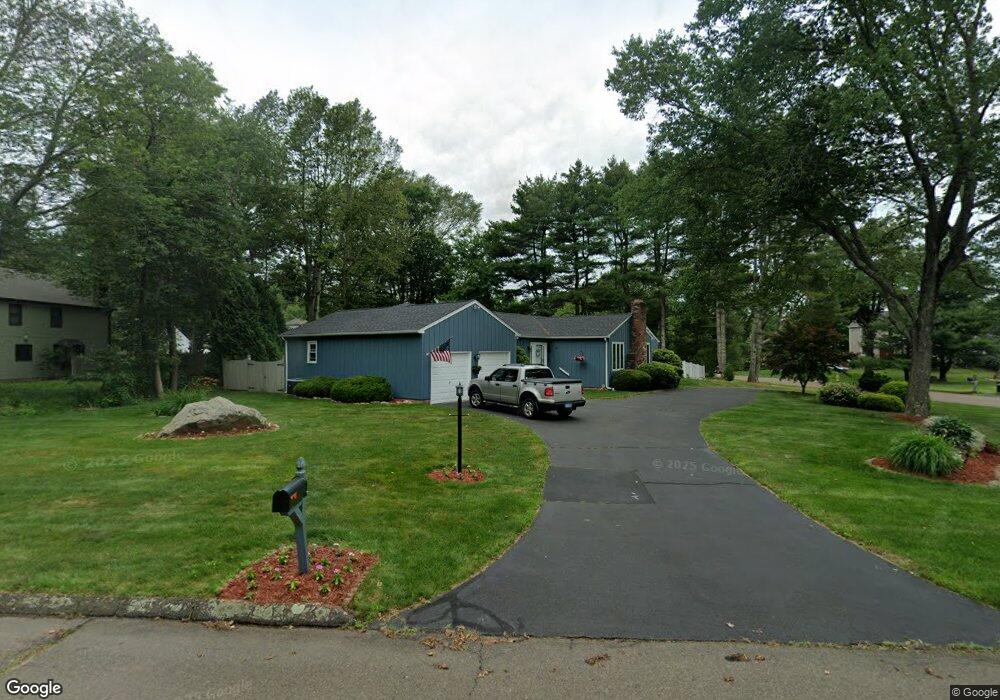
16 Deer Path Rd Branford, CT 06405
Estimated Value: $698,000 - $866,000
3
Beds
3
Baths
2,750
Sq Ft
$275/Sq Ft
Est. Value
About This Home
This home is located at 16 Deer Path Rd, Branford, CT 06405 and is currently estimated at $757,331, approximately $275 per square foot. 16 Deer Path Rd is a home located in New Haven County with nearby schools including Francis Walsh Intermediate School, Branford High School, and East Shoreline Catholic Academy.
Ownership History
Date
Name
Owned For
Owner Type
Purchase Details
Closed on
Apr 6, 1994
Sold by
Citizens Bk Ma
Bought by
Savino Frank A and Savino Donna M
Current Estimated Value
Purchase Details
Closed on
Jan 27, 1994
Sold by
Feniola Louis E
Bought by
Boston Five Cents Sb
Create a Home Valuation Report for This Property
The Home Valuation Report is an in-depth analysis detailing your home's value as well as a comparison with similar homes in the area
Home Values in the Area
Average Home Value in this Area
Purchase History
| Date | Buyer | Sale Price | Title Company |
|---|---|---|---|
| Savino Frank A | $175,000 | -- | |
| Boston Five Cents Sb | $166,500 | -- |
Source: Public Records
Mortgage History
| Date | Status | Borrower | Loan Amount |
|---|---|---|---|
| Open | Boston Five Cents Sb | $400,000 | |
| Closed | Boston Five Cents Sb | $192,019 |
Source: Public Records
Tax History
| Year | Tax Paid | Tax Assessment Tax Assessment Total Assessment is a certain percentage of the fair market value that is determined by local assessors to be the total taxable value of land and additions on the property. | Land | Improvement |
|---|---|---|---|---|
| 2025 | $10,206 | $476,900 | $118,300 | $358,600 |
| 2024 | $9,199 | $301,800 | $103,300 | $198,500 |
| 2023 | $9,021 | $301,800 | $103,300 | $198,500 |
| 2022 | $8,888 | $301,800 | $103,300 | $198,500 |
| 2021 | $8,888 | $301,800 | $103,300 | $198,500 |
| 2020 | $8,728 | $301,800 | $103,300 | $198,500 |
| 2019 | $8,451 | $290,700 | $110,500 | $180,200 |
| 2018 | $8,326 | $290,700 | $110,500 | $180,200 |
| 2017 | $8,276 | $290,700 | $110,500 | $180,200 |
| 2016 | $7,968 | $290,700 | $110,500 | $180,200 |
| 2015 | $7,829 | $290,700 | $110,500 | $180,200 |
| 2014 | $8,231 | $313,700 | $110,500 | $203,200 |
Source: Public Records
Map
Nearby Homes
- 17 Arrowhead Ln
- 86 Pine Orchard Rd
- 15 Oak Hollow Rd
- 7 Dogwood Ct
- 15 Griffing Pond Rd
- 200 Damascus Rd
- 16 Pine Orchard Rd Unit 27
- 2 Riverwalk
- 53 Montowese St
- 8 Meadow Circle Rd
- 9 4th Ave
- 39 Manorwood Dr
- 10 Hamre Ln Unit C
- 251 N Main St
- 7 Hamre Ln Unit A
- 104 S Montowese St
- 137 S Montowese St
- 178 S Montowese St
- 49 Rose St Unit 204
- 8 Gaylea Dr
- 12 Deer Path Rd
- 42 Indian Woods Rd
- 17 Deer Path Rd
- 29 Indian Woods Rd
- 21 Deer Path Rd
- 13 Deer Path Rd
- 38 Indian Woods Rd
- 8 Deer Path Rd
- 25 Indian Woods Rd
- 25 Deer Path Rd
- 9 Deer Path Rd
- 24 Deer Path Rd
- 69 Damascus Rd Unit B
- 69 Damascus Rd
- 69 Damascus Rd Unit A
- 16 Soffer Place
- 12 Soffer Place
- 4 Deer Path Rd
- 30 Indian Woods Rd
- 20 Soffer Place
Your Personal Tour Guide
Ask me questions while you tour the home.