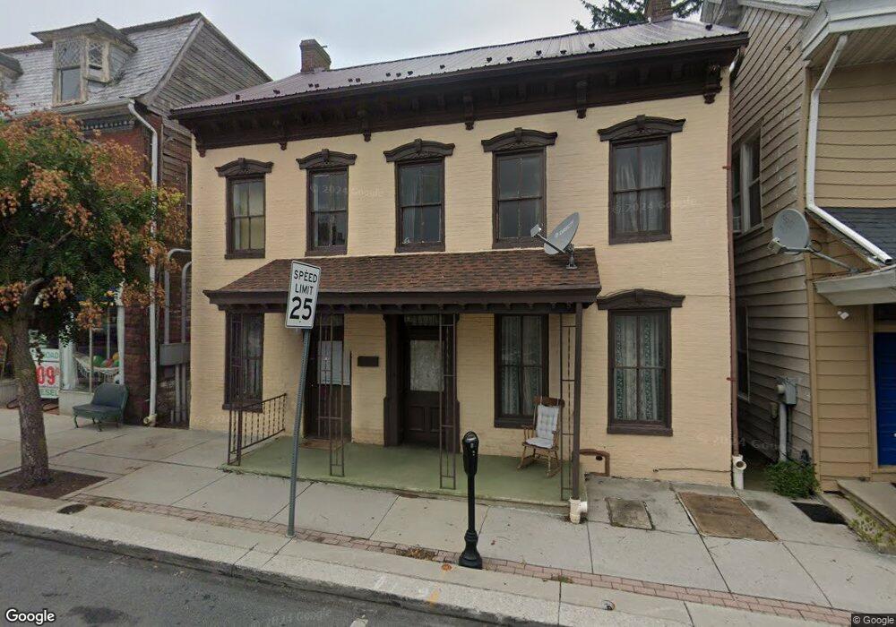
16 E King St Littlestown, PA 17340
Estimated Value: $120,000 - $281,867
5
Beds
2
Baths
3,520
Sq Ft
$63/Sq Ft
Est. Value
About This Home
This home is located at 16 E King St, Littlestown, PA 17340 and is currently estimated at $221,967, approximately $63 per square foot. 16 E King St is a home located in Adams County with nearby schools including Rolling Acres El School, Maple Avenue Middle School, and Littlestown Senior High School.
Ownership History
Date
Name
Owned For
Owner Type
Purchase Details
Closed on
Jan 14, 2025
Sold by
Frock Sarah M and Foster Wendy D
Bought by
Moreno Bartolo Ponce and Mercado Maria Benereida Va
Current Estimated Value
Purchase Details
Closed on
Mar 6, 2017
Sold by
Frock Sarah M and Frock Terry L
Bought by
Frock Sarah M
Purchase Details
Closed on
Oct 2, 1992
Bought by
Frock Terry L
Create a Home Valuation Report for This Property
The Home Valuation Report is an in-depth analysis detailing your home's value as well as a comparison with similar homes in the area
Home Values in the Area
Average Home Value in this Area
Purchase History
| Date | Buyer | Sale Price | Title Company |
|---|---|---|---|
| Moreno Bartolo Ponce | $115,000 | Lawyers Express Title Llc | |
| Moreno Bartolo Ponce | $115,000 | Lawyers Express Title Llc | |
| Moreno Bartolo Ponce | $115,000 | Lawyers Express Title Llc | |
| Frock Sarah M | $147,600 | None Available | |
| Frock Terry L | -- | -- |
Source: Public Records
Tax History
| Year | Tax Paid | Tax Assessment Tax Assessment Total Assessment is a certain percentage of the fair market value that is determined by local assessors to be the total taxable value of land and additions on the property. | Land | Improvement |
|---|---|---|---|---|
| 2025 | $3,395 | $147,700 | $44,800 | $102,900 |
| 2024 | $3,272 | $147,700 | $44,800 | $102,900 |
| 2023 | $3,145 | $147,700 | $44,800 | $102,900 |
| 2022 | $3,126 | $147,700 | $44,800 | $102,900 |
| 2021 | $3,034 | $147,700 | $44,800 | $102,900 |
| 2020 | $2,997 | $147,700 | $44,800 | $102,900 |
| 2019 | $2,907 | $147,700 | $44,800 | $102,900 |
| 2018 | $2,854 | $147,700 | $44,800 | $102,900 |
| 2017 | $2,779 | $147,600 | $44,700 | $102,900 |
| 2016 | -- | $147,600 | $44,700 | $102,900 |
| 2015 | -- | $147,600 | $44,700 | $102,900 |
| 2014 | -- | $147,600 | $44,700 | $102,900 |
Source: Public Records
Map
Nearby Homes
- 115 Charles St
- 117 Charles St
- 102 Cemetery St
- 102 N Queen St
- 45 James Ave
- 230 M St
- 161 Cemetery St
- 141 W King St
- 484 S Columbus Ave Unit 19
- 162 Newark St
- 17 Mason Dixon Dr Unit 84
- 311 S Columbus Ave Unit 128
- 41 Smith Cir
- 20 Stedtle Ave
- 535 Lumber St
- 7 Stoners Cir
- 61 Stoners Cir
- 559 Lumber St
- 11 Yorktowne Ct Unit 96
- 567 Lumber St
Your Personal Tour Guide
Ask me questions while you tour the home.