Estimated Value: $834,597 - $912,000
4
Beds
3
Baths
2,477
Sq Ft
$351/Sq Ft
Est. Value
About This Home
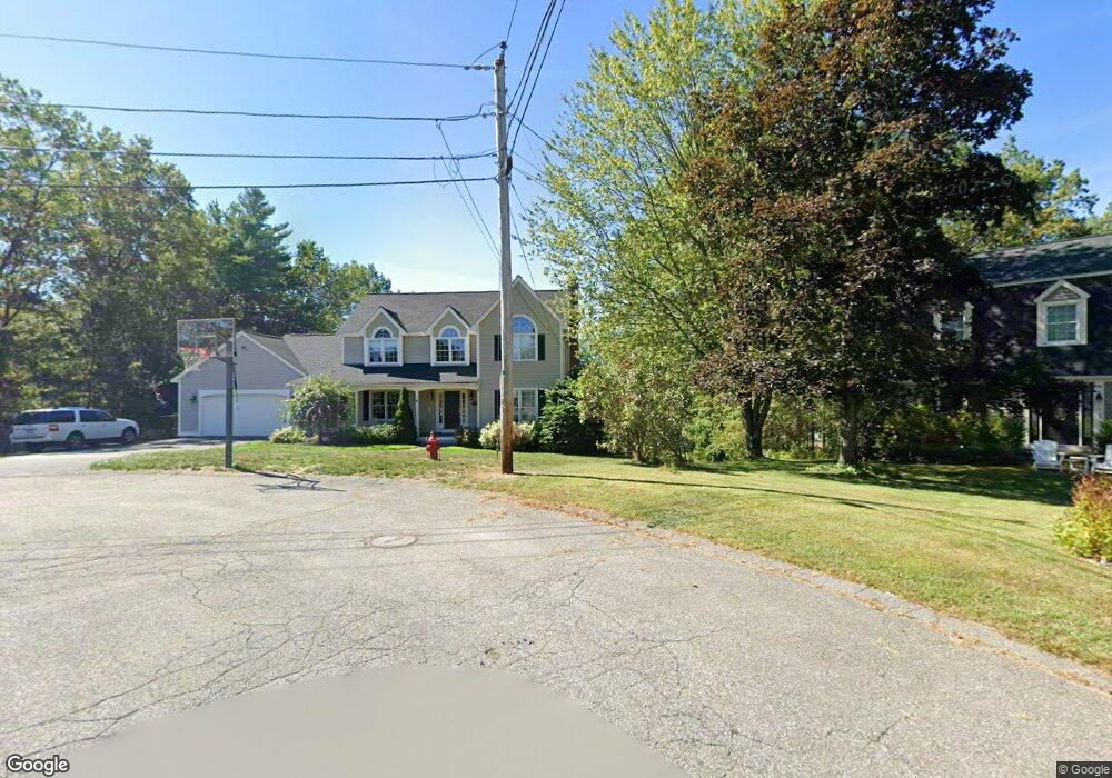
This home is located at 16 Madigan Ln, Ayer, MA 01432 and is currently estimated at $869,649, approximately $351 per square foot. 16 Madigan Ln is a home located in Middlesex County with nearby schools including Page Hilltop School, Lura A. White Elementary School, and Ayer Shirley Regional Middle School.
Ownership History
Date
Name
Owned For
Owner Type
Purchase Details
Closed on
Dec 13, 2024
Sold by
Horgan Kevin P and Horgan Laurie A
Bought by
Hutt Hannah
Current Estimated Value
Purchase Details
Closed on
Apr 19, 1996
Sold by
Morse Donald A
Bought by
Horgan Kevin P and Horgan Laurie A
Create a Home Valuation Report for This Property
The Home Valuation Report is an in-depth analysis detailing your home's value as well as a comparison with similar homes in the area
Home Values in the Area
Average Home Value in this Area
Purchase History
| Date | Buyer | Sale Price | Title Company |
|---|---|---|---|
| Hutt Hannah | -- | None Available | |
| Hutt Hannah | -- | None Available | |
| Hutt Hannah | -- | None Available | |
| Horgan Kevin P | $50,000 | -- |
Source: Public Records
Mortgage History
| Date | Status | Borrower | Loan Amount |
|---|---|---|---|
| Previous Owner | Horgan Kevin P | $296,000 | |
| Previous Owner | Horgan Kevin P | $100,000 | |
| Previous Owner | Horgan Kevin P | $151,100 | |
| Previous Owner | Horgan Kevin P | $15,000 |
Source: Public Records
Tax History Compared to Growth
Tax History
| Year | Tax Paid | Tax Assessment Tax Assessment Total Assessment is a certain percentage of the fair market value that is determined by local assessors to be the total taxable value of land and additions on the property. | Land | Improvement |
|---|---|---|---|---|
| 2025 | $9,471 | $791,900 | $190,200 | $601,700 |
| 2024 | $9,048 | $738,600 | $190,200 | $548,400 |
| 2023 | $8,617 | $693,800 | $190,200 | $503,600 |
| 2022 | $8,379 | $624,400 | $165,400 | $459,000 |
| 2021 | $8,282 | $585,700 | $156,400 | $429,300 |
| 2020 | $7,803 | $553,400 | $150,400 | $403,000 |
| 2019 | $7,424 | $544,700 | $143,300 | $401,400 |
| 2018 | $0 | $520,900 | $139,100 | $381,800 |
| 2017 | $7,146 | $496,600 | $135,100 | $361,500 |
| 2016 | $6,852 | $471,600 | $131,300 | $340,300 |
| 2015 | $6,852 | $468,700 | $131,300 | $337,400 |
| 2014 | $6,497 | $461,400 | $131,300 | $330,100 |
Source: Public Records
Map
Nearby Homes
- 121 Culver Rd
- 18 Douglas Dr
- 17 Douglas Dr
- 16 Jonathan Dr
- 326 Old Ayer Rd
- 25 Groton School Rd Unit 14
- 25 Groton School Rd Unit 23
- 72 Dale Ln
- 8 High St
- 0 High St
- 9 Nashua St
- 21 High St
- 38 Pine Ridge Dr
- 28 West St Unit 6B
- 14 Brook St
- PL 639 Indian Hill Rd
- 7 Groveland St
- 41 E Main St
- 17 Grove St
- 27 Grove St
- 15 Madigan Ln
- 10 Madigan Ln
- 14 Madigan Ln
- 13 Madigan Ln
- 8 Madigan Ln
- 9 Madigan Ln
- 7 Madigan Ln
- 12 Madigan Ln
- 12 Madigan Ln
- 6 Madigan Ln
- 5 Madigan Ln
- 2 Madigan Ln
- 180 Washington St
- 3 Madigan Ln
- 1 Madigan Ln
- 188 Washington St
- 187 Old Groton Rd
- 201 Washington St
- 190 Groton Rd Unit 230
- 179 Washington St