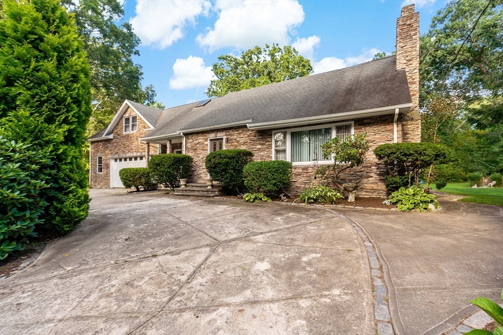
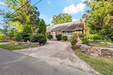
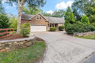
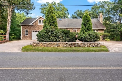
16 Martin St Rehoboth, MA 02769
Estimated payment $3,657/month
Highlights
- Golf Course Community
- Cape Cod Architecture
- Wooded Lot
- Community Stables
- Wood Burning Stove
- 4-minute walk to Everett "Red" McPhillips Complex
About This Home
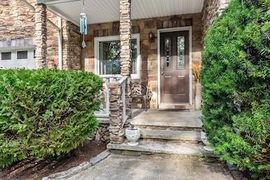
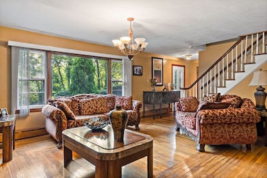
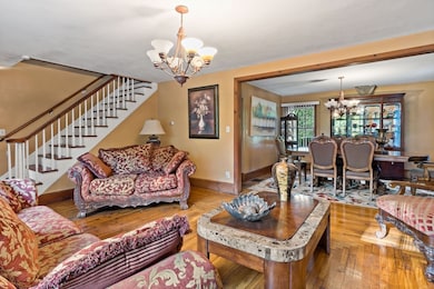
Come see this very roomy Cape w/ potential 4 to 5 bedrooms on a wooded lot in quiet beautiful Rehoboth. This home features a formal living room with fireplace, formal dining area big enough for the finest of dinners. Upon entering you will view an open concept from the family room into the eat in kitchen area with access through a sliding glass door to the large backyard. This home also features 1.5 baths, 2 car garage w/ plenty of off road parking as well and a full dry basement housing a wood stove & laundry. The custom stone work on homes facing is extremely eye catching along with the country custom stone wall aproning the property. The sellers will be installing a brand new 4 bedroom septic prior to closing. Make Rehoboth country living your town here in this well maintained Cape.
Home Details
Home Type
- Single Family
Est. Annual Taxes
- $5,290
Year Built
- Built in 1953
Lot Details
- 1.85 Acre Lot
- Wooded Lot
Parking
- 2 Car Attached Garage
- Driveway
- Open Parking
- Off-Street Parking
Home Design
- Cape Cod Architecture
- Frame Construction
- Shingle Roof
- Concrete Perimeter Foundation
- Stone
Interior Spaces
- 2,230 Sq Ft Home
- 1 Fireplace
- Wood Burning Stove
- Window Screens
- Basement Fills Entire Space Under The House
- Range
- Washer and Gas Dryer Hookup
Flooring
- Wood
- Tile
Bedrooms and Bathrooms
- 3 Bedrooms
Outdoor Features
- Outdoor Storage
- Rain Gutters
- Porch
Location
- Property is near schools
Utilities
- No Cooling
- Heating System Uses Oil
- Baseboard Heating
- 100 Amp Service
- Private Water Source
- Electric Water Heater
- Private Sewer
Listing and Financial Details
- Assessor Parcel Number 2939113
Community Details
Overview
- No Home Owners Association
- Near Conservation Area
Amenities
- Shops
Recreation
- Golf Course Community
- Community Stables
- Jogging Path
Map
Home Values in the Area
Average Home Value in this Area
Tax History
| Year | Tax Paid | Tax Assessment Tax Assessment Total Assessment is a certain percentage of the fair market value that is determined by local assessors to be the total taxable value of land and additions on the property. | Land | Improvement |
|---|---|---|---|---|
| 2025 | $53 | $474,400 | $175,900 | $298,500 |
| 2024 | $4,826 | $424,800 | $175,900 | $248,900 |
| 2023 | $4,829 | $417,000 | $172,300 | $244,700 |
| 2022 | $4,542 | $358,500 | $172,300 | $186,200 |
| 2021 | $4,814 | $363,600 | $164,500 | $199,100 |
| 2020 | $4,683 | $356,900 | $164,500 | $192,400 |
| 2018 | $3,804 | $317,800 | $156,700 | $161,100 |
| 2017 | $4,413 | $295,500 | $156,700 | $138,800 |
| 2016 | $3,509 | $288,800 | $156,700 | $132,100 |
| 2015 | $3,512 | $285,300 | $149,500 | $135,800 |
| 2014 | $3,339 | $268,400 | $142,300 | $126,100 |
Property History
| Date | Event | Price | List to Sale | Price per Sq Ft |
|---|---|---|---|---|
| 09/03/2025 09/03/25 | For Sale | $610,000 | -- | $274 / Sq Ft |
Purchase History
| Date | Type | Sale Price | Title Company |
|---|---|---|---|
| Deed | $133,000 | -- |
Mortgage History
| Date | Status | Loan Amount | Loan Type |
|---|---|---|---|
| Open | $339,000 | No Value Available | |
| Closed | $113,000 | Purchase Money Mortgage |
Source: MLS Property Information Network (MLS PIN)
MLS Number: 73424738
APN: REHO-000010-000000-000031
Disclaimer: Certain information contained herein is derived from information provided by parties other than Homes.com. All information provided is deemed reliable, but is not guaranteed to be accurate and should be independently verified.
![]() The property listing data and information, or the Images, set forth herein were provided to MLS Property Information Network, Inc. from third party sources, including sellers, lessors and public records, and were compiled by MLS Property Information Network, Inc. The property listing data and information, and the Images, are for the personal, non-commercial use of consumers having a good faith interest in purchasing or leasing listed properties of the type displayed to them and may not be used for any purpose other than to identify prospective properties which such consumers may have a good faith interest in purchasing or leasing. MLS Property Information Network, Inc. and its subscribers disclaim any and all representations and warranties as to the accuracy of the property listing data and information, or as to the accuracy of any of the Images, set forth herein.
The property listing data and information, or the Images, set forth herein were provided to MLS Property Information Network, Inc. from third party sources, including sellers, lessors and public records, and were compiled by MLS Property Information Network, Inc. The property listing data and information, and the Images, are for the personal, non-commercial use of consumers having a good faith interest in purchasing or leasing listed properties of the type displayed to them and may not be used for any purpose other than to identify prospective properties which such consumers may have a good faith interest in purchasing or leasing. MLS Property Information Network, Inc. and its subscribers disclaim any and all representations and warranties as to the accuracy of the property listing data and information, or as to the accuracy of any of the Images, set forth herein.
- 16 Ashlynn Way
- 75 Martin St
- 283 Plain St
- 47 Spring St
- 92 Martin St
- 9 Sophia Dr
- 7 Johnnies Way
- 129 Cameron Way
- 49 Sophia Dr
- 50 Sophia Dr
- 51 Sophia Dr
- 120 Plain St
- 397RR Locust St
- 36 Columbine Rd
- 14 Deborah Ann Dr Unit 41
- 2 Deborah Ann Dr Unit 44
- 267 Chestnut St
- 42 Linden Ln
- 383 Vinnicum Rd
- 850 Hortonville Rd
- 49 Spring St
- 515 Winthrop St Unit 1
- 43 Serpentine Rd
- 27 Commonwealth Ave Unit 2
- 21 Wallis Ave Unit 1
- 108 Shawomet Ave Unit 3
- 6 Orchard Ave Unit 2
- 218-220 Old Colony Ave Unit 202
- 91 Main St Unit 101
- 91 Main St Unit 259
- 352 Main St Unit 3
- 99 Main St
- 176 Child St
- 508 Grand Army of the Republic Highway St
- 193 Child St Unit 2
- 24 Linden Rd
- 24 Linden Rd Unit 1
- 37 Warren Ave Unit 1
- 99 Water St
- 421 Main St
