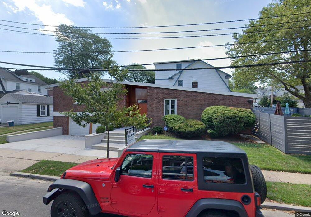
16 Mathews Ave Staten Island, NY 10310
West Brighton NeighborhoodEstimated Value: $765,023 - $1,076,000
--
Bed
4
Baths
1,272
Sq Ft
$747/Sq Ft
Est. Value
About This Home
This home is located at 16 Mathews Ave, Staten Island, NY 10310 and is currently estimated at $950,756, approximately $747 per square foot. 16 Mathews Ave is a home located in Richmond County with nearby schools including P.S. 45 John Tyler, Is 61 William A Morris, and Curtis High School.
Ownership History
Date
Name
Owned For
Owner Type
Purchase Details
Closed on
Dec 17, 2018
Sold by
Cavalcante Dawn
Bought by
Decaro Peter S and Leavy Kevin J
Current Estimated Value
Home Financials for this Owner
Home Financials are based on the most recent Mortgage that was taken out on this home.
Original Mortgage
$515,000
Outstanding Balance
$454,632
Interest Rate
4.9%
Mortgage Type
New Conventional
Estimated Equity
$496,124
Purchase Details
Closed on
Jan 31, 2007
Sold by
Beiles Susan A
Bought by
Cavalcante Dawn
Home Financials for this Owner
Home Financials are based on the most recent Mortgage that was taken out on this home.
Original Mortgage
$504,000
Interest Rate
6.27%
Mortgage Type
Purchase Money Mortgage
Create a Home Valuation Report for This Property
The Home Valuation Report is an in-depth analysis detailing your home's value as well as a comparison with similar homes in the area
Home Values in the Area
Average Home Value in this Area
Purchase History
| Date | Buyer | Sale Price | Title Company |
|---|---|---|---|
| Decaro Peter S | $790,000 | Chicago Title Insurance Co | |
| Cavalcante Dawn | $560,000 | Titledge.Com Inc |
Source: Public Records
Mortgage History
| Date | Status | Borrower | Loan Amount |
|---|---|---|---|
| Open | Decaro Peter S | $515,000 | |
| Previous Owner | Cavalcante Dawn | $504,000 |
Source: Public Records
Tax History Compared to Growth
Tax History
| Year | Tax Paid | Tax Assessment Tax Assessment Total Assessment is a certain percentage of the fair market value that is determined by local assessors to be the total taxable value of land and additions on the property. | Land | Improvement |
|---|---|---|---|---|
| 2025 | $8,363 | $40,080 | $22,465 | $17,615 |
| 2024 | $8,363 | $41,640 | $21,531 | $20,109 |
| 2023 | $8,420 | $41,460 | $21,812 | $19,648 |
| 2022 | $8,349 | $41,820 | $20,400 | $21,420 |
| 2021 | $8,940 | $44,100 | $20,400 | $23,700 |
| 2020 | $8,683 | $43,800 | $20,400 | $23,400 |
| 2019 | $8,096 | $38,700 | $20,400 | $18,300 |
| 2018 | $7,649 | $37,524 | $17,334 | $20,190 |
| 2017 | $7,216 | $35,400 | $20,400 | $15,000 |
| 2016 | $7,125 | $35,640 | $20,400 | $15,240 |
| 2015 | $6,195 | $34,216 | $15,927 | $18,289 |
| 2014 | $6,195 | $32,280 | $17,400 | $14,880 |
Source: Public Records
Map
Nearby Homes
- 1 Whitewood Ave
- 1 Sunset Hill Dr
- 34 Harvest Ave
- 145 Norma Place
- 605 Bard Ave
- 100 Lawrence Ave
- 372 Sharon Ave
- 67 Lawrence Ave
- 20 Baker Place
- 710 Oakland Ave
- 152 Harvest Ave
- 215 Hart Blvd Unit 4C
- 215 Hart Blvd Unit 3L
- 58-62 University Place
- 125 Walbrooke Ave
- 64 Greenway Dr
- 44 Greenway Dr
- 244 Delafield Ave
- 40 Greenway Dr
- 72 Gregg Place