Estimated Value: $876,244 - $1,195,000
4
Beds
3
Baths
2,732
Sq Ft
$369/Sq Ft
Est. Value
About This Home
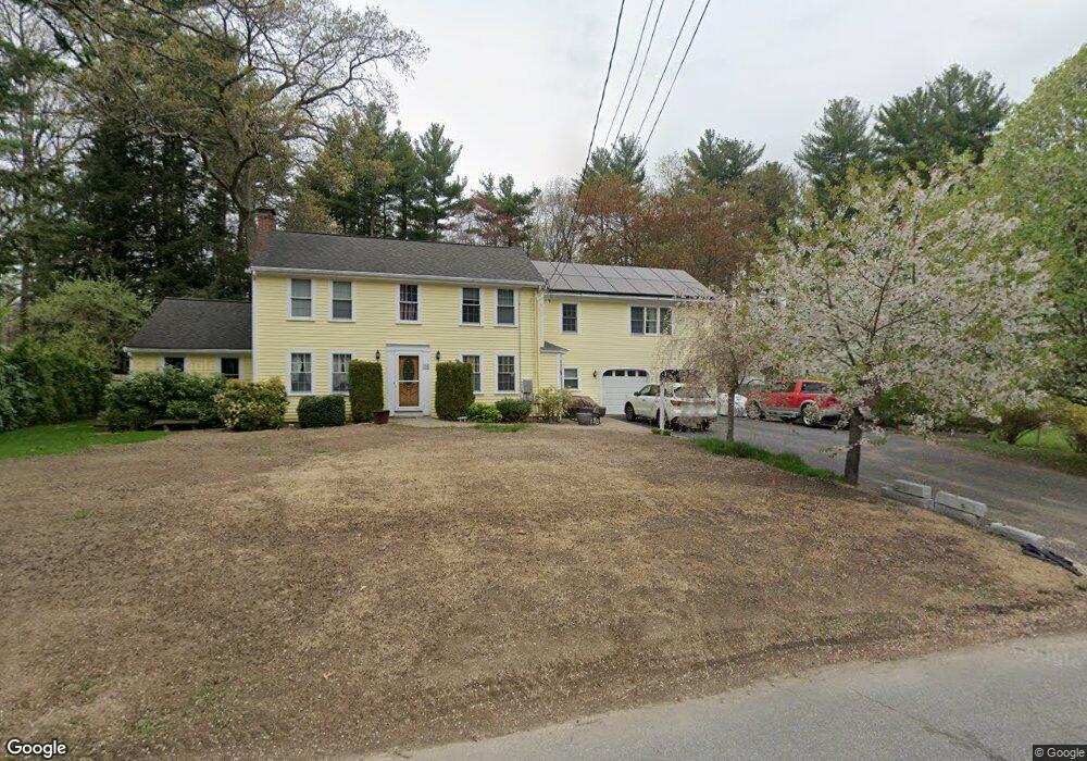
This home is located at 16 Mohegan Rd, Acton, MA 01720 and is currently estimated at $1,007,311, approximately $368 per square foot. 16 Mohegan Rd is a home located in Middlesex County with nearby schools including Acton-Boxborough Regional High School.
Ownership History
Date
Name
Owned For
Owner Type
Purchase Details
Closed on
Oct 9, 2020
Sold by
Messuri David L and Messuri Mari L
Bought by
Messuri Mari L
Current Estimated Value
Home Financials for this Owner
Home Financials are based on the most recent Mortgage that was taken out on this home.
Original Mortgage
$375,000
Outstanding Balance
$331,405
Interest Rate
2.8%
Mortgage Type
New Conventional
Estimated Equity
$675,906
Purchase Details
Closed on
Apr 29, 1997
Sold by
Coll Karen H and Coll Thomas D
Bought by
Messuri David L and Messuri Mari L
Home Financials for this Owner
Home Financials are based on the most recent Mortgage that was taken out on this home.
Original Mortgage
$176,700
Interest Rate
7.77%
Mortgage Type
Purchase Money Mortgage
Purchase Details
Closed on
May 19, 1987
Sold by
Lesure Lydia R
Bought by
Coll Karen H
Create a Home Valuation Report for This Property
The Home Valuation Report is an in-depth analysis detailing your home's value as well as a comparison with similar homes in the area
Home Values in the Area
Average Home Value in this Area
Purchase History
| Date | Buyer | Sale Price | Title Company |
|---|---|---|---|
| Messuri Mari L | -- | None Available | |
| Messuri David L | $279,000 | -- | |
| Coll Karen H | $236,000 | -- |
Source: Public Records
Mortgage History
| Date | Status | Borrower | Loan Amount |
|---|---|---|---|
| Open | Messuri Mari L | $375,000 | |
| Previous Owner | Coll Karen H | $127,500 | |
| Previous Owner | Coll Karen H | $105,000 | |
| Previous Owner | Coll Karen H | $176,700 |
Source: Public Records
Tax History Compared to Growth
Tax History
| Year | Tax Paid | Tax Assessment Tax Assessment Total Assessment is a certain percentage of the fair market value that is determined by local assessors to be the total taxable value of land and additions on the property. | Land | Improvement |
|---|---|---|---|---|
| 2025 | $13,506 | $787,500 | $313,400 | $474,100 |
| 2024 | $12,626 | $757,400 | $313,400 | $444,000 |
| 2023 | $12,313 | $701,200 | $285,000 | $416,200 |
| 2022 | $11,654 | $599,200 | $247,800 | $351,400 |
| 2021 | $11,584 | $572,600 | $229,400 | $343,200 |
| 2020 | $10,924 | $567,800 | $229,400 | $338,400 |
| 2019 | $10,444 | $539,200 | $229,400 | $309,800 |
| 2018 | $10,262 | $529,500 | $229,400 | $300,100 |
| 2017 | $10,001 | $524,700 | $229,400 | $295,300 |
| 2016 | $9,809 | $510,100 | $229,400 | $280,700 |
| 2015 | $9,302 | $488,300 | $229,400 | $258,900 |
| 2014 | $9,013 | $463,400 | $229,400 | $234,000 |
Source: Public Records
Map
Nearby Homes
- 31 Mohawk Dr
- 4 Huron Rd
- 9 Elm St Unit 1
- 5 Elm St Unit 1
- 285 Central St Unit 285
- 89 Windsor Ave
- 68 Macintosh Ln
- 134 Russet Ln
- 4,7,8 Crestwood Ln
- 92 Willow St Unit 3
- 92 Willow St Unit 2
- 90 Willow St Unit 1
- 4 Omega Way
- 23 John Swift Rd
- 30 Paul Revere Rd
- 169 Main St
- 491 Main St
- 777 Depot Rd
- 524 Main St
- 19 Railroad St Unit C2