16 Pershing Cir O Fallon, MO 63366
Estimated Value: $304,000 - $324,000
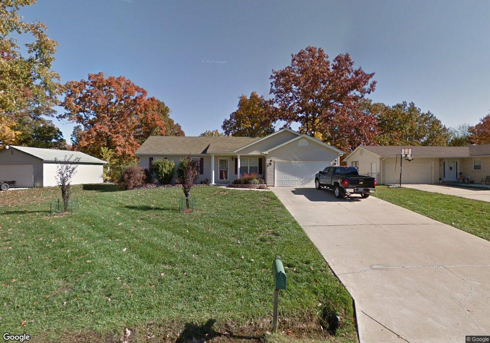
About This Home
This home is located at 16 Pershing Cir, O Fallon, MO 63366 and is currently estimated at $313,594, approximately $218 per square foot. 16 Pershing Cir is a home located in St. Charles County with nearby schools including Green Tree Elementary School, Wentzville South Middle School, and Timberland High School.
Ownership History
We collect this data history from publicly available records. To have your information removed, we recommend requesting removal directly through your county’s website.
Purchase Details
Purchase Details
Home Financials for this Owner
Home Financials are based on the most recent Mortgage that was taken out on this home.Purchase Details
Home Financials for this Owner
Home Financials are based on the most recent Mortgage that was taken out on this home.Purchase Details
Home Financials for this Owner
Home Financials are based on the most recent Mortgage that was taken out on this home.Purchase Details
Home Financials for this Owner
Home Financials are based on the most recent Mortgage that was taken out on this home.Home Values in the Area
Average Home Value in this Area
Purchase History
We collect this data history from publicly available records. To have your information removed, we recommend requesting removal directly through your county’s website.
| Date | Buyer | Sale Price | Title Company |
|---|---|---|---|
| -- | None Listed On Document | ||
| -- | Ust | ||
| -- | Inv | ||
| -- | -- | ||
| -- | -- |
Mortgage History
We collect this data history from publicly available records. To have your information removed, we recommend requesting removal directly through your county’s website.
| Date | Status | Borrower | Loan Amount |
|---|---|---|---|
| Previous Owner | $147,920 | ||
| Previous Owner | $117,370 | ||
| Previous Owner | $117,300 | ||
| Previous Owner | $120,605 | ||
| Closed | $15,000 |
Tax History
We collect this data history from publicly available records. To have your information removed, we recommend requesting removal directly through your county’s website.
| Year | Tax Paid | Tax Assessment Tax Assessment Total Assessment is a certain percentage of the fair market value that is determined by local assessors to be the total taxable value of land and additions on the property. | Land | Improvement |
|---|---|---|---|---|
| 2025 | $3,210 | $55,200 | -- | -- |
| 2023 | $3,209 | $48,786 | $0 | $0 |
| 2022 | $2,804 | $39,621 | $0 | $0 |
| 2021 | $2,801 | $39,621 | $0 | $0 |
| 2020 | $2,717 | $37,474 | $0 | $0 |
| 2019 | $2,522 | $37,474 | $0 | $0 |
| 2018 | $2,084 | $29,427 | $0 | $0 |
| 2017 | $2,074 | $29,427 | $0 | $0 |
| 2016 | $1,854 | $26,106 | $0 | $0 |
| 2015 | $1,822 | $26,106 | $0 | $0 |
| 2014 | $1,762 | $25,847 | $0 | $0 |
Map
- 42 N Kern Dr
- 20 W Ofallon Dr
- 14 Brockton Cir
- 11 S Meadow Dr
- 48 Rue de Paix Unit 39
- 591 Midland Dr
- 28 Forest Ln
- 706 Norwood Terrace
- 537 Oak Hill Dr
- 1437 Sunview Dr
- 1433 Sunview Dr
- 1412 Apple Valley Dr
- 833 Brookmead Dr
- 821 Brookmead Dr
- 705 Russett Terrace
- 806 Conch Terrace
- 609 Lakewood Dr
- 544 Forest Crest
- 1159 Sunset Green Dr
- 1419 Sunburst Dr
Ask me questions while you tour the home.