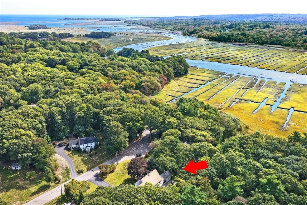
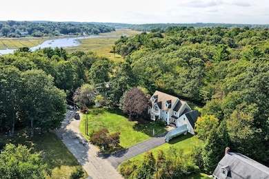
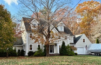
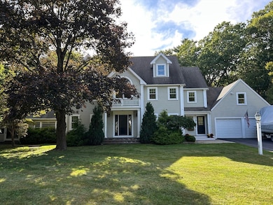
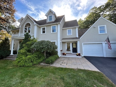
16 Salt Meadow Ln Scituate, MA 02066
Estimated payment $8,433/month
Highlights
- Golf Course Community
- Scenic Views
- Colonial Architecture
- Jenkins Elementary School Rated A-
- 0.93 Acre Lot
- Deck
About This Home
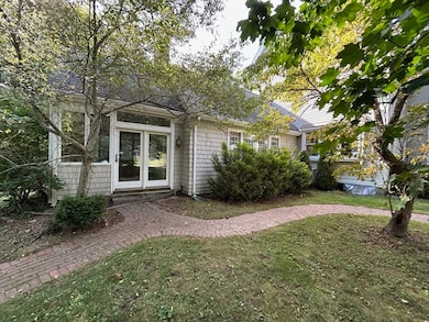
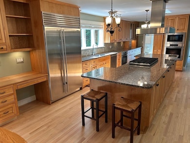
10/4/3.5 handsome center entrance colonial on cul de sac w/ views of North River. Wonderful home on a child safe street in a very quiet, sought-after neighborhood. 38’ chef’s kitchen w/ Miele appliances & 48” Subzero refrigerator. 13' granite topped island w/ gas 6 burner cooktop.Butler’s pantry has 2nd dishwasher. Formal living & dining room. Sun-filled cathedral family room w/ raised hearth fireplace. 3 story foyer & large mudroom. Upgraded moldings & trim including 6 custom arches on 1st FL.Hardwood & tile floors; 1st FL floors refinished. Master BR has Italian tiled marble bath, walk-in closet & private balcony. 2 BRs share a Jack-and-Jill bath. 4th BR has ensuite bath. 2nd FL laundry. Walk-up entrance to large/bright 50’ attic, roughed for heat. 2nd walk-up attic over garage. Large, finished, insulated game room in basement. Heated 4 season sunroom. 35’ Trex & cedar deck & a large bluestone patio. 1 acre level lot w/ Large, private back yard. Not located in flood plain/flood zone.
Open House Schedule
-
Saturday, November 15, 202511:00 am to 1:00 pm11/15/2025 11:00:00 AM +00:0011/15/2025 1:00:00 PM +00:00Add to Calendar
-
Sunday, November 16, 202512:00 to 2:00 pm11/16/2025 12:00:00 PM +00:0011/16/2025 2:00:00 PM +00:00Add to Calendar
Home Details
Home Type
- Single Family
Est. Annual Taxes
- $11,243
Year Built
- Built in 2007
Lot Details
- 0.93 Acre Lot
- Property fronts a private road
- Cul-De-Sac
- Level Lot
- Wooded Lot
- Garden
Parking
- 2 Car Attached Garage
- Oversized Parking
- Workshop in Garage
- Garage Door Opener
- Driveway
- Open Parking
- Off-Street Parking
Home Design
- Colonial Architecture
- Frame Construction
- Blown Fiberglass Insulation
- Shingle Roof
- Concrete Perimeter Foundation
Interior Spaces
- Central Vacuum
- 1 Fireplace
- Insulated Windows
- Insulated Doors
- Mud Room
- Scenic Vista Views
- Attic Ventilator
Kitchen
- Oven
- Range with Range Hood
- Microwave
- Plumbed For Ice Maker
- Dishwasher
- Disposal
Flooring
- Wood
- Tile
Bedrooms and Bathrooms
- 4 Bedrooms
Laundry
- ENERGY STAR Qualified Dryer
- ENERGY STAR Qualified Washer
Partially Finished Basement
- Basement Fills Entire Space Under The House
- Interior Basement Entry
- Sump Pump
- Block Basement Construction
Eco-Friendly Details
- Energy-Efficient Thermostat
- Whole House Vacuum System
- Watersense Fixture
Outdoor Features
- Bulkhead
- Balcony
- Deck
- Patio
- Gazebo
- Rain Gutters
- Porch
Location
- Property is near public transit
Schools
- Jenkins Elementary School
- Gates Middle School
- Scituate High School
Utilities
- Central Heating and Cooling System
- 3 Cooling Zones
- 4 Heating Zones
- Heating System Uses Oil
- Heat Pump System
- Radiant Heating System
- Baseboard Heating
- 200+ Amp Service
- Power Generator
- Electric Water Heater
- Private Sewer
Listing and Financial Details
- Assessor Parcel Number M:057 B:002 L:005B,1170210
Community Details
Overview
- No Home Owners Association
- Near Conservation Area
Recreation
- Golf Course Community
- Jogging Path
Map
Home Values in the Area
Average Home Value in this Area
Tax History
| Year | Tax Paid | Tax Assessment Tax Assessment Total Assessment is a certain percentage of the fair market value that is determined by local assessors to be the total taxable value of land and additions on the property. | Land | Improvement |
|---|---|---|---|---|
| 2025 | $11,243 | $1,125,400 | $438,000 | $687,400 |
| 2024 | $11,109 | $1,072,300 | $398,100 | $674,200 |
| 2023 | $10,671 | $985,200 | $362,000 | $623,200 |
| 2022 | $10,671 | $845,600 | $316,400 | $529,200 |
| 2021 | $10,243 | $768,400 | $301,400 | $467,000 |
| 2020 | $9,918 | $734,700 | $289,700 | $445,000 |
| 2019 | $10,135 | $737,600 | $312,400 | $425,200 |
| 2018 | $9,884 | $708,500 | $317,000 | $391,500 |
| 2017 | $9,614 | $682,300 | $305,200 | $377,100 |
| 2016 | $9,315 | $658,800 | $281,700 | $377,100 |
| 2015 | $8,322 | $635,300 | $258,200 | $377,100 |
Property History
| Date | Event | Price | List to Sale | Price per Sq Ft |
|---|---|---|---|---|
| 10/17/2025 10/17/25 | Price Changed | $1,425,000 | -4.7% | $432 / Sq Ft |
| 10/07/2025 10/07/25 | Price Changed | $1,495,000 | -5.1% | $453 / Sq Ft |
| 09/25/2025 09/25/25 | For Sale | $1,575,000 | -- | $477 / Sq Ft |
Purchase History
| Date | Type | Sale Price | Title Company |
|---|---|---|---|
| Quit Claim Deed | -- | -- | |
| Deed | $785,000 | -- |
Mortgage History
| Date | Status | Loan Amount | Loan Type |
|---|---|---|---|
| Open | $270,000 | New Conventional | |
| Previous Owner | $369,500 | No Value Available | |
| Previous Owner | $170,000 | No Value Available |
Source: MLS Property Information Network (MLS PIN)
MLS Number: 73435724
APN: SCIT-000057-000002-000005B
Disclaimer: Certain information contained herein is derived from information provided by parties other than Homes.com. All information provided is deemed reliable, but is not guaranteed to be accurate and should be independently verified.
![]() The property listing data and information, or the Images, set forth herein were provided to MLS Property Information Network, Inc. from third party sources, including sellers, lessors and public records, and were compiled by MLS Property Information Network, Inc. The property listing data and information, and the Images, are for the personal, non-commercial use of consumers having a good faith interest in purchasing or leasing listed properties of the type displayed to them and may not be used for any purpose other than to identify prospective properties which such consumers may have a good faith interest in purchasing or leasing. MLS Property Information Network, Inc. and its subscribers disclaim any and all representations and warranties as to the accuracy of the property listing data and information, or as to the accuracy of any of the Images, set forth herein.
The property listing data and information, or the Images, set forth herein were provided to MLS Property Information Network, Inc. from third party sources, including sellers, lessors and public records, and were compiled by MLS Property Information Network, Inc. The property listing data and information, and the Images, are for the personal, non-commercial use of consumers having a good faith interest in purchasing or leasing listed properties of the type displayed to them and may not be used for any purpose other than to identify prospective properties which such consumers may have a good faith interest in purchasing or leasing. MLS Property Information Network, Inc. and its subscribers disclaim any and all representations and warranties as to the accuracy of the property listing data and information, or as to the accuracy of any of the Images, set forth herein.
- 9 Cushing Park Rd
- 48 Neal Gate St
- 146 Chief Justice Cushing Hwy
- 49 Cornet Stetson Rd
- 28 Riverside Cir
- 17 Old Oaken Bucket Rd
- 2167 Main St
- 19 Ford Place Unit 3
- 19 Ford Place Unit 1
- 19 Ford Place Unit 4
- 12 Sassamon Rd
- 161 Cross St
- 29 Ladds Way Unit 29
- 110 Parker St
- 908 Main St
- 252 Winter St
- 3 Cottage Ln
- 3 Webster Farm Way
- 5 Webster Farm Way
- 25 Webster Farm Way
- 130 Chief Justice Cushing Hwy
- 130 Chief Justice Cushing Hwy Unit 410
- 130 Chief Justice Cushing Hwy Unit 213
- 130 Chief Justice Cushing Hwy Unit 408
- 340-348 Driftway
- 145 Driftway
- 44 Elm St Unit 2
- 44 Elm St Unit 3
- 66 Earldor Cir Unit B
- 6 Maple Ave Unit 6A
- 272 Central Ave
- 18 Maple Ave
- 230 Central Ave (Weekly Summer)
- 65 Brockton Ave
- 15 10th Ave
- 92 Marion Rd Unit LOWER
- 92 Marion Rd Unit UPPER
- 105 Turner Rd
- 79 Kenneth Rd
- 66 Mann Lot Rd Unit R
