
Seller's Agent in 2025
Donna Sides
Keller Williams Realty Boston Northwest
(978) 844-1474
29 in this area
51 Total Sales
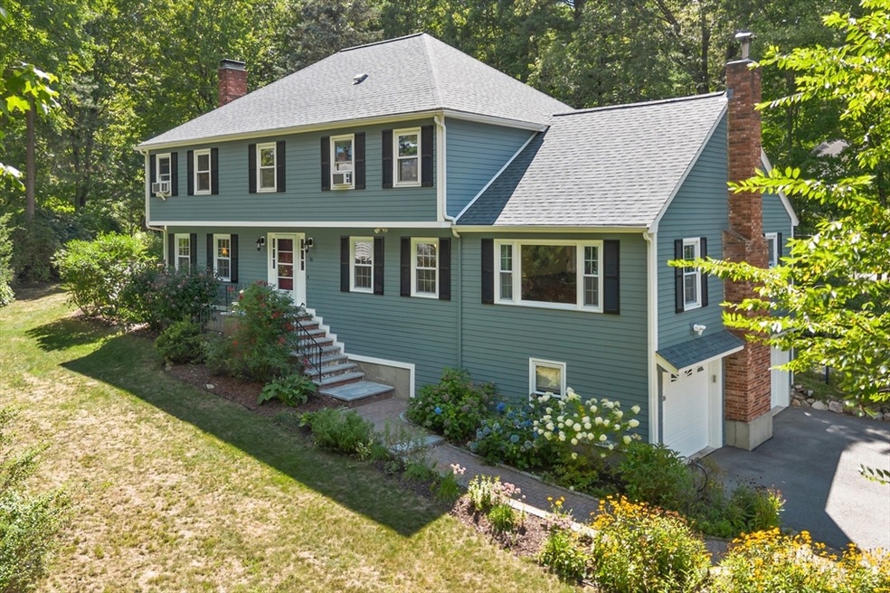


Pride of ownership shines in this 10-room Colonial nestled on a private acre-plus lot. Featuring 4 bedrooms and 2.5 baths, the home showcases a stunning remodeled kitchen, stylishly updated baths, wide plank hardwood floors, and three fireplaces that invite warmth and togetherness. The first floor offers a sun-filled family room with wood stove, a formal living room with wood-burning fireplace & private office—providing flexible space for today’s lifestyle. The 2nd floor has a spacious primary suite, three good sized bedrooms & updated baths. A finished lower level includes a gym, game room, pantry, laundry, and mudroom with direct access to the oversized 2-car garage. Enjoy your serene backyard from the private deck or relax in the 3-season sunroom w/ floor-to-ceiling windows. Set in a desirable neighborhood near Concord, Maynard and South Acton commuter rail. Minutes to shops, dining and top-rated Acton-Boxborough schools. Welcome Home.
Last Agent to Sell the Property
Keller Williams Realty Boston Northwest Listed on: 09/03/2025
| Date | Type | Sale Price | Title Company |
|---|---|---|---|
| Quit Claim Deed | $1,160,000 | -- | |
| Quit Claim Deed | -- | None Available | |
| Land Court Massachusetts | $600,000 | -- | |
| Land Court Massachusetts | $600,000 | -- | |
| Land Court Massachusetts | $535,000 | -- |
| Date | Status | Loan Amount | Loan Type |
|---|---|---|---|
| Open | $870,000 | Purchase Money Mortgage | |
| Previous Owner | $417,000 | Purchase Money Mortgage | |
| Previous Owner | $360,000 | Purchase Money Mortgage |
| Date | Event | Price | List to Sale | Price per Sq Ft |
|---|---|---|---|---|
| 10/10/2025 10/10/25 | Sold | $1,160,000 | +1.8% | $332 / Sq Ft |
| 09/04/2025 09/04/25 | Pending | -- | -- | -- |
| 09/03/2025 09/03/25 | For Sale | $1,139,000 | -- | $326 / Sq Ft |
| Year | Tax Paid | Tax Assessment Tax Assessment Total Assessment is a certain percentage of the fair market value that is determined by local assessors to be the total taxable value of land and additions on the property. | Land | Improvement |
|---|---|---|---|---|
| 2025 | $16,752 | $976,800 | $377,700 | $599,100 |
| 2024 | $15,651 | $938,900 | $377,700 | $561,200 |
| 2023 | $15,279 | $870,100 | $344,100 | $526,000 |
| 2022 | $14,687 | $755,100 | $298,500 | $456,600 |
| 2021 | $14,355 | $709,600 | $277,000 | $432,600 |
| 2020 | $13,537 | $703,600 | $277,000 | $426,600 |
| 2019 | $13,028 | $672,600 | $277,000 | $395,600 |
| 2018 | $12,992 | $670,400 | $277,000 | $393,400 |
| 2017 | $12,658 | $664,100 | $277,000 | $387,100 |
| 2016 | $12,405 | $645,100 | $277,000 | $368,100 |
| 2015 | $12,066 | $633,400 | $277,000 | $356,400 |
| 2014 | $11,892 | $611,400 | $277,000 | $334,400 |
Seller's Agent in 2025
Donna Sides
Keller Williams Realty Boston Northwest
(978) 844-1474
29 in this area
51 Total Sales
Buyer's Agent in 2025
Carolyn Boyle
Gibson Sothebys International Realty
(617) 962-7514
1 in this area
61 Total Sales
Source: MLS Property Information Network (MLS PIN)
MLS Number: 73422813
APN: ACTO-000003I-000064-000019
Disclaimer: Certain information contained herein is derived from information provided by parties other than Homes.com. All information provided is deemed reliable, but is not guaranteed to be accurate and should be independently verified.
![]() The property listing data and information, or the Images, set forth herein were provided to MLS Property Information Network, Inc. from third party sources, including sellers, lessors and public records, and were compiled by MLS Property Information Network, Inc. The property listing data and information, and the Images, are for the personal, non-commercial use of consumers having a good faith interest in purchasing or leasing listed properties of the type displayed to them and may not be used for any purpose other than to identify prospective properties which such consumers may have a good faith interest in purchasing or leasing. MLS Property Information Network, Inc. and its subscribers disclaim any and all representations and warranties as to the accuracy of the property listing data and information, or as to the accuracy of any of the Images, set forth herein.
The property listing data and information, or the Images, set forth herein were provided to MLS Property Information Network, Inc. from third party sources, including sellers, lessors and public records, and were compiled by MLS Property Information Network, Inc. The property listing data and information, and the Images, are for the personal, non-commercial use of consumers having a good faith interest in purchasing or leasing listed properties of the type displayed to them and may not be used for any purpose other than to identify prospective properties which such consumers may have a good faith interest in purchasing or leasing. MLS Property Information Network, Inc. and its subscribers disclaim any and all representations and warranties as to the accuracy of the property listing data and information, or as to the accuracy of any of the Images, set forth herein.
Ask me questions while you tour the home.