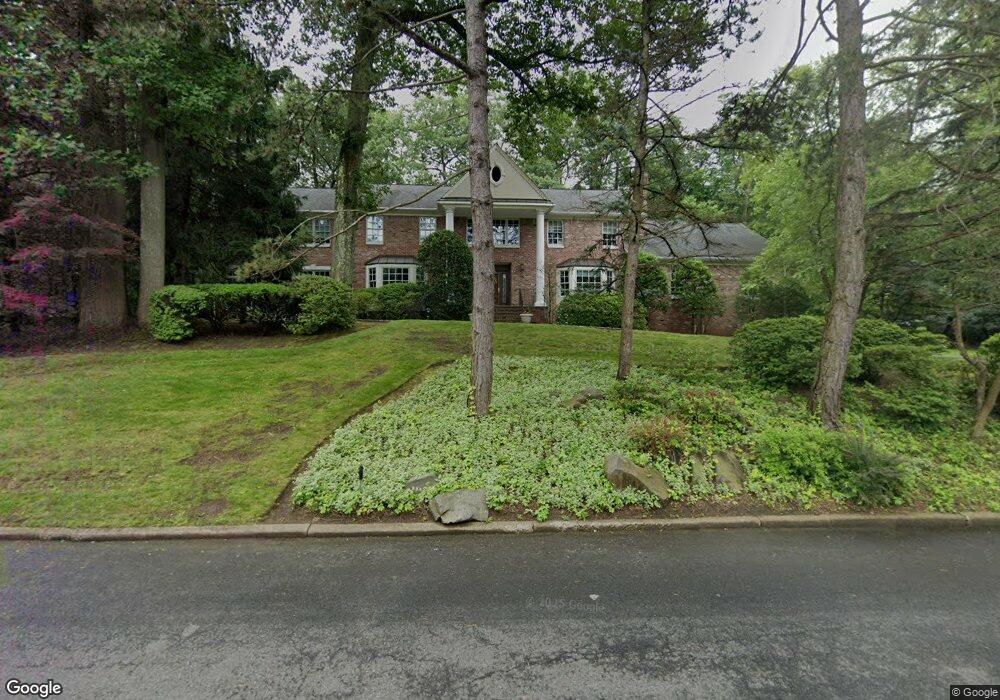
160 Hoover Dr Cresskill, NJ 07626
Estimated Value: $2,986,426 - $3,320,000
Studio
--
Bath
6,393
Sq Ft
$490/Sq Ft
Est. Value
About This Home
This home is located at 160 Hoover Dr, Cresskill, NJ 07626 and is currently estimated at $3,132,607, approximately $490 per square foot. 160 Hoover Dr is a home located in Bergen County with nearby schools including Cresskill High School, Spring School, and Academy Of The Holy Angels.
Ownership History
Date
Name
Owned For
Owner Type
Purchase Details
Closed on
Jul 10, 2009
Sold by
Mullin Anderson Timothy Jon and Mullin Anderson Karen
Bought by
Fink Lawrence R and Fink Josephine
Current Estimated Value
Purchase Details
Closed on
Aug 10, 1998
Sold by
Boiardi Joseph C and Boiardi Angela
Bought by
Mullin Anderson Timothy Jon and Mullin Anderson Karen
Home Financials for this Owner
Home Financials are based on the most recent Mortgage that was taken out on this home.
Original Mortgage
$615,000
Interest Rate
6.75%
Create a Home Valuation Report for This Property
The Home Valuation Report is an in-depth analysis detailing your home's value as well as a comparison with similar homes in the area
Home Values in the Area
Average Home Value in this Area
Purchase History
| Date | Buyer | Sale Price | Title Company |
|---|---|---|---|
| Fink Lawrence R | $1,800,000 | -- | |
| Mullin Anderson Timothy Jon | $798,500 | -- |
Source: Public Records
Mortgage History
| Date | Status | Borrower | Loan Amount |
|---|---|---|---|
| Previous Owner | Mullin Anderson Timothy Jon | $615,000 |
Source: Public Records
Tax History
| Year | Tax Paid | Tax Assessment Tax Assessment Total Assessment is a certain percentage of the fair market value that is determined by local assessors to be the total taxable value of land and additions on the property. | Land | Improvement |
|---|---|---|---|---|
| 2025 | $45,163 | $2,061,200 | $644,500 | $1,416,700 |
| 2024 | $43,964 | $1,963,600 | $599,500 | $1,364,100 |
| 2023 | $43,357 | $1,894,200 | $567,000 | $1,327,200 |
| 2022 | $43,357 | $1,801,300 | $527,000 | $1,274,300 |
| 2021 | $42,650 | $1,746,500 | $509,500 | $1,237,000 |
| 2020 | $41,891 | $1,722,500 | $507,000 | $1,215,500 |
| 2019 | $41,798 | $1,736,500 | $504,500 | $1,232,000 |
| 2018 | $29,547 | $1,752,500 | $497,000 | $1,255,500 |
| 2017 | $44,333 | $1,628,700 | $475,500 | $1,153,200 |
| 2016 | $43,014 | $1,628,700 | $475,500 | $1,153,200 |
| 2015 | $41,678 | $1,628,700 | $475,500 | $1,153,200 |
| 2014 | $40,424 | $1,628,700 | $475,500 | $1,153,200 |
Source: Public Records
Map
Nearby Homes
- 110 Eisenhower Dr
- 165 Hoover Dr
- 150 Hoover Dr
- 118 Eisenhower Dr
- 101 Eisenhower Dr
- 151 Hoover Dr
- 88 Eisenhower Dr
- 171 Hoover Dr
- 109 Eisenhower Dr
- 142 Hoover Dr
- 126 Eisenhower Dr
- 117 Eisenhower Dr
- 15 E Hill Ct
- 80 Eisenhower Dr
- 87 Eisenhower Dr
- 178 Hoover Dr
- 125 Eisenhower Dr
- 134 Hoover Dr
- 23 Van Buren Ct
- 134 Eisenhower Dr
Your Personal Tour Guide
Ask me questions while you tour the home.