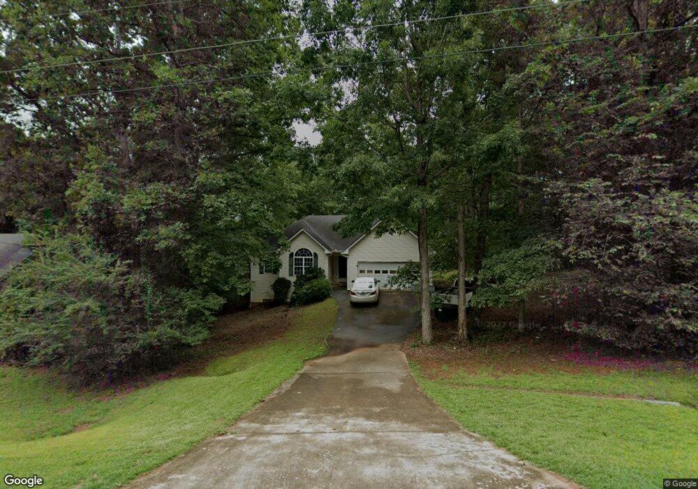
160 Sable Cir Unit 3 Covington, GA 30016
Estimated Value: $240,094 - $272,000
Studio
2
Baths
1,478
Sq Ft
$173/Sq Ft
Est. Value
About This Home
This home is located at 160 Sable Cir Unit 3, Covington, GA 30016 and is currently estimated at $255,774, approximately $173 per square foot. 160 Sable Cir Unit 3 is a home located in Newton County with nearby schools including South Salem Elementary School, Liberty Middle School, and Alcovy High School.
Ownership History
Date
Name
Owned For
Owner Type
Purchase Details
Closed on
Apr 4, 2001
Sold by
Camp Wayne
Bought by
Whitehead Nathaniel
Current Estimated Value
Home Financials for this Owner
Home Financials are based on the most recent Mortgage that was taken out on this home.
Original Mortgage
$96,739
Outstanding Balance
$34,579
Interest Rate
7.11%
Mortgage Type
FHA
Estimated Equity
$221,195
Create a Home Valuation Report for This Property
The Home Valuation Report is an in-depth analysis detailing your home's value as well as a comparison with similar homes in the area
Home Values in the Area
Average Home Value in this Area
Purchase History
| Date | Buyer | Sale Price | Title Company |
|---|---|---|---|
| Whitehead Nathaniel | $105,900 | -- |
Source: Public Records
Mortgage History
| Date | Status | Borrower | Loan Amount |
|---|---|---|---|
| Open | Whitehead Nathaniel | $96,739 |
Source: Public Records
Tax History
| Year | Tax Paid | Tax Assessment Tax Assessment Total Assessment is a certain percentage of the fair market value that is determined by local assessors to be the total taxable value of land and additions on the property. | Land | Improvement |
|---|---|---|---|---|
| 2025 | $2,405 | $103,080 | $14,000 | $89,080 |
| 2024 | $2,316 | $95,280 | $14,000 | $81,280 |
| 2023 | $2,474 | $95,040 | $6,000 | $89,040 |
| 2022 | $1,967 | $76,360 | $6,000 | $70,360 |
| 2021 | $1,745 | $61,440 | $6,000 | $55,440 |
| 2020 | $1,588 | $51,160 | $6,000 | $45,160 |
| 2019 | $1,388 | $44,600 | $6,000 | $38,600 |
| 2018 | $1,435 | $45,680 | $6,000 | $39,680 |
| 2017 | $1,308 | $42,000 | $6,000 | $36,000 |
| 2016 | $1,127 | $36,720 | $3,800 | $32,920 |
| 2015 | $961 | $31,880 | $3,200 | $28,680 |
| 2014 | $674 | $23,560 | $0 | $0 |
Source: Public Records
Map
Nearby Homes
- 415 Rosser Rd
- 275 Roberts Rd
- 417 Rosser Rd
- 7 Glynnshire Ct
- 100 Creekside Ln
- 35 Charity Chase
- 30 Freedom Ct
- 50 Freedom Ct
- 30 Emerson Trail
- 55 Emerson Trail
- 345 Timberlake Terrace
- 75 Tulip Dr
- 615 St Annes Place
- 10 Logans Run
- 110 Greenway Dr
- 800 Mills Dr
- 165 Tulip Dr
- 40 Freebia Walk
- 225 Dairyland Dr
- 20 Greenway Dr
- 170 Sable Cir Unit 3/17
- 170 Sable Cir Unit 17
- 170 Sable Cir
- 150 Sable Cir Unit 3
- 140 Sable Cir Unit 3
- 265 Sable Cir Unit 3
- 200 Sable Cir
- 130 Sable Cir
- 260 Sable Cir
- 105 Sable Cir
- 75 Freebia Walk
- 55 Freebia Walk
- 20 Freebia Walk
- 65 Freebia Walk
- 50 Freebia Walk
- 30 Freebia Walk
- 95 Freebia Walk
- 85 Freebia Walk
- 60 Freebia Walk
- 10 Freebia Walk
Your Personal Tour Guide
Ask me questions while you tour the home.